Eoropie
From Wikishire
| Eoropie Gaelic: Eòrapaidh | |
| Ross-shire | |
|---|---|
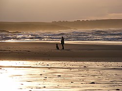
 The beach at Eoropie | |
| Location | |
| Island: | Lewis |
| Grid reference: | NB515650 |
| Location: | 58°30’11"N, 6°15’58"W |
| Data | |
| Post town: | Isle of Lewis |
| Postcode: | HS2 |
| Dialling code: | 01851 |
| Local Government | |
| Council: | Na h-Eileanan Siar |
| Parliamentary constituency: |
Na h-Eileanan an Iar |
Eoropie is the most northerly village on the Isle of Lewis in Ross-shire. Eoropie is within the parish of Barvas.[1] The Teampull Mholuaidh is to be found here. Eoropie is situated at the end of the B8013 and B8014 roads, from Lionel and Port of Ness, respectively.[2][3]
It is just south of the Butt of Lewis and contains the Eoropie Dunes Park. It is beside a beautiful beach at Traigh Shanndaigh.
References
- ↑ "Details of Eoropie". Scottish Places. http://www.scottish-places.info/towns/towndetails4907.html. Retrieved 23 December 2014.
- ↑ "B8013". Sabre. http://www.sabre-roads.org.uk/wiki/index.php?title=B8013. Retrieved 23 December 2014.
- ↑ "B8014". Sabre. http://www.sabre-roads.org.uk/wiki/index.php?title=B8014. Retrieved 23 December 2014.
Outside links
| ("Wikimedia Commons" has material about Eoropie) |