Enfield, Meath
| Enfield Gaelic: An Bóthar Buí | |
| Meath | |
|---|---|

| |
| Location | |
| Grid reference: | N775412 |
| Location: | 53°24’50"N, 6°49’48"W |
| Data | |
| Population: | 2,929 (2011) |
| Post town: | Enfield |
| Postcode: | A83 |
| Local Government | |
| Council: | Meath |
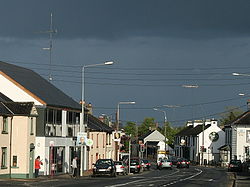
Enfield or Innfield[1] is a town in southern Meath, situated between Kilcock and Kinnegad and very close to the border with County Kildare. The town is on the Dublin-Sligo railway line. It is located on the R148 regional road,[1] formerly the N4 national primary road connecting Dublin to Connaught. Its name in Irish, An Bóthar Buí means 'the yellow road'.
Contents
Local history
Enfield's phased growth is paralleled with the various phases of transport history throughout the south of the county. Going back to Ancient Times, prior to and during the early part of the first millennium A.D., the Enfield area is believed to have been situated on one of the main roads to Tara, the coronation site and seat of the high Kings of Ireland from the 3rd Century until 1022. From the great heart and centre of the Irish Kingdom, five great arteries or roads radiated from Tara to the various parts of the country the Slighe (a way or path) Cualann, which ran toward the present County Wicklow, the Slighe Mor, the great Western road, which ran via Dublin to Galway, the Slighe Asail which ran near the present Mullingar, the Slighe Dala which ran south-west, and the Slighe Midluachra, the Northern road.
During Norman times (from 1169) under the Fitzgeralds, Earls of Kildare, a road was built from Maynooth Castle to Courtown House in Kilcock, to the Windmill on Cappagh Hill, to Cloncurry over to Johnstown House (now the Johnstown House Hotel and Spa), and from there on to Newcastle and Ballina House.
When the Stage Coach was used as a form of transport in Ireland, this road took a slightly different route to include the area that is now known as Enfield. The road between Dublin and Mullingar running through Enfield was built in 1735.
A livery stable and courtyard existed opposite the old postoffice building (now a Chinese Restaurant) at the East end of the town, to service people travelling on this road. Fresh teams of horses were available for hire at the livery stable when the coaches stopped at the postoffice. The building also provided some stopover accommodation. Some of the remains of the original livery courtyard could be seen adjacent to the Centra supermarket and car park. These sites were protected once by the Office of Public Works but unfortunately have made way for redevelopment in 2014. The first postal deliveries by stage coach, in the area, occurred around 1740, during the time of Robert Fitzgerald, 19th Earl of Kildare.
In the 1790s, maps denote the site as "A New Inn", later "The New Inn" and eventually, Innfield. This derives from a mail-coach inn on the 18th century Dublin to Mullingar coach route called 'The Royal Oak Inn' which is estimated to have been where the Bridge House Inn now stands. The Royal Canal also passed through Innfield, and with the arrival of the Midland Great Western Railway the name change to Enfield. The name Innfield became Enfield towards the end of the 19th century when a new postmaster came from Enfield, Middlesex and decided to use the same name for the area. The N4, the main road to the west from Dublin, passed through Enfield and plagued it with traffic problems. In December 2005 a new stretch of the M4 motorway opened and most traffic now bypasses the town. The section of the N4 which was bypassed has been redesignated as the R148.[1]
Transport
Canal
The Royal Canal construction began in Dublin in 1790 and this signalled the end of the stage coach era, as the canals were a cheaper and more efficient means of transport. The stretch from Dublin to Mullingar opened as a trade route around 1807 and the canal eventually reached the Shannon in 1817, though the company was heavily in debt. The decision by the Duke of Leinster to build a spur from the canal to his country residence, at Carton House, was one of the contributing factors which finally broke the company.
Even though rail travel was much quicker, the canal continued to carry traffic until the 1950s. It is only now that the potential of the Canal for tourism and as a natural amenity is being realised. The Office of Public Works took charge of it in 1986 and subsequent investment and significant restoration means it has great prospects of becoming popular again as a means of leisurely transport
Railway
The railway reached Enfield in 1847, when the Midland Great Western Railway opened between Broadstone station in Dublin and Enfield railway station (opened on 28 June 1847).[2]
Upon the opening of the railway, canal boats ceased all passenger traffic between Dublin and Enfield, passengers travelling west using the train to Enfield and transferring to the canal in the town. With the canal and the railway had stop over points in Enfield, and this contributed to the development of the area.
The line was extended to Hill of Down by the end of 1847 and to Mullingar in October 1848. In 1877, a branch line from Nesbitt Junction (to the west of Enfield) to Edenderry was opened. The Edenderry branch line and Enfield station closed in 1963, although there had been no regular passenger service to Edenderry since 1931.
Passenger services from Enfield resumed in 1988.
Local attractions
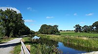
- There is an amenity park along with a small harbour and slipway at the Royal Canal on the western side of the town.
- Enfield is has several pubs along Main Street. These include The Slighe Mór, The Midland Bar, and The Bridge House.
- Enfield also has its own micro-brewery, The Celtic Brew company based in nearby Clonard which produces the award-winning Finian's Lager.
Sport
- Local golf courses include The Rathcore Golf and Country Club and the Darren Clarke-designed Champions Club in Moyvalley.
- The town is home to Na Fianna Gaelic Athletic Association club.
- The town is also home to Enfield Celtic football club est. 1989
Outside links
| ("Wikimedia Commons" has material about Enfield, Meath) |
References
- ↑ 1.0 1.1 1.2 Ordnance Survey of Ireland map
- ↑ "Enfield station". Railscot - Irish Railways. http://www.railscot.co.uk/Ireland/Irish_railways.pdf. Retrieved 2007-09-06.

