Eglwyscummin
| Eglwyscummin Welsh: Eglwys Gymyn | |
| Carmarthenshire | |
|---|---|
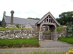
 Eglwyscummin Church | |
| Location | |
| Location: | 51°45’58"N, 4°33’58"W |
| Data | |
| Population: | 432 (2011[1]) |
| Post town: | Carmarthen |
| Postcode: | SA33 |
| Dialling code: | 01994 |
| Local Government | |
| Council: | Carmarthenshire |
| Parliamentary constituency: |
Carmarthen West and South Pembrokeshire |
Eglwyscummin is an ancient parish situated on the south-western bounds of Carmarthenshire.
The parish is crossed by the B4314 road running south-eastwards from the county border at Tavernspite to the seaside resort of Pendine Sands.
Church
Thie parish church is dedicated to St Margaret and was built c.1093. It has an ancient circular churchyard and is believed to be situated on the site of an ancient church dating back to AD 500.
History
The name originally derives from the Welsh Eglwys, meaning 'church' with the addition of the name of St Cynin. The Gothic Revival architect C.C. Rolfe restored St Margaret's parish church in 1878.[2] Eglwyscummin is the only known place where an Ogham inscription commemorates a woman: Avitoriges, daughter of Cunigni.
Eglwyscummin was constituted a civil parish in 1894 which merged with those of Cyffic and Marros in 1935.
References
Sources
- Lloyd, Thomas (2006). The Buildings of Wales: Carmarthernshire and Ceredigion. ISBN 0-300-10179-1.
- Saint, Andrew (1970). "Three Oxford Architects". Oxonensia (Oxfordshire Architectural and Historical Society) XXXV: 53 ff. http://www.oahs.org.uk/oxo/vol%2035/Saint.doc. Retrieved 3 November 2009.