Edgware
From Wikishire
Revision as of 20:31, 4 November 2010 by RB (Talk | contribs) (Created page with '{{Infobox town | name = Edgware | county = Middlesex | picture = Edgware June 2010.JPG | picture caption = Station Road, Edgware; facing North | os grid ref = TQ195925 | latitude…')
| Edgware | |
| Middlesex | |
|---|---|
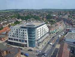
 Station Road, Edgware; facing North | |
| Location | |
| Grid reference: | TQ195925 |
| Location: | 51°37’7"N, 0°16’22"W |
| Data | |
| Post town: | Edgware |
| Postcode: | HA8 |
| Dialling code: | 020 |
| Local Government | |
| Council: | Barnet |
| Parliamentary constituency: |
Hendon |
Edgware is a town of Middlesex on Watling Street, known in the county as the Edgware Road after this town. Edgware was a separate village until perhaps the early twentieth century. When the railway (now the Northern Line) was extended to Edgware, the village swelled enormously and in time joined the London conurbation.
Edgware's High Street is a section of the Edgware Road, itself the Middlesex section of the old Roman Road known as Watling Street. Much remains of the village in structure along the High Street, if little of its old buildings other than the parish church and two collections of almshouses.
This Middlesex article is a stub: help to improve Wikishire by building it up.