Eastington, Stroud
| Eastington | |
| Gloucestershire | |
|---|---|
| Location | |
| Grid reference: | SO774053 |
| Location: | 51°44’46"N, 2°19’34"W |
| Data | |
| Post town: | Stonehouse |
| Postcode: | GL10 |
| Local Government | |
| Council: | Stroud |
| Parliamentary constituency: |
Stroud |
Eastington is a village in Gloucestershire, 4 miles west of Stroud and 9 miles south of Gloucester at the entrance to the Stroud Valley.
Eastington is found west of the town of Stonehouse and is convenient for Junction 13 of the M5 motorway and the A38 and A419 roads. Since the M5 and its access roads were opened, the main road no longer runs through the village.
About the village
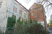
Eastington has a number of farms and former mills.
There are a small number of retail outlets including a Co-op, a butchers, two pubs, two hairdressers, and a garage. There is also a village hall, where the brownie pack and rainbow pack meet, and a primary school, which has about 120 students. There is also a community building where Eastington playgroup and various clubs are held. At nearby Claypits there is a farm shop which sells oil and animal feed, and a coach company.
The nature reserve of Five Acre Grove lies close to the village and is designated a Key Wildlife Site.[1]
Churches
There are two churches, one Church of England, and the other a Methodist.
Outside links
| ("Wikimedia Commons" has material about Eastington, Stroud) |
- Eastington - Elrington et al. (1972), A History of the County of Gloucester: Volume 10, pp. 123–139. Victoria County History series
- Eastington on GENUKI
- Eastington Primary School
- Owen Harris Sports and Playing Fields
