Difference between revisions of "East Wivelshire"
From Wikishire
| Line 1: | Line 1: | ||
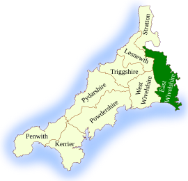
[[File:East Wivelshire.svg|right|thumb|270px|East Wivelshire located]] | [[File:East Wivelshire.svg|right|thumb|270px|East Wivelshire located]] | ||
| − | '''East Wivelshire''' is the south-easternmost of the ten hundreds of Cornwall, along the lower reaches of the [[River Tamar]] and the manifold creeks that indent its complex estuary and as far north as [[Launceston]]. The hundred is the eastern part of the wider district known as [[Wivelshire]]. It is identified on [[Ordnance Survey]] maps and census reports as simply the '''East Hundred'''. | + | '''East Wivelshire''' is the south-easternmost of the ten hundreds of Cornwall, along the lower reaches of the [[River Tamar]] and the manifold creeks that indent its complex estuary and as far north as [[Launceston]]. The hundred is the eastern part of the wider district known as [[Wivelshire]]. It is identified on [[Ordnance Survey]] maps and census reports as simply the '''East Hundred'''. It had a population of 71,779 in 2011. |
The ancient parishes of East Wivelshire are: | The ancient parishes of East Wivelshire are: | ||
Revision as of 11:21, 2 December 2019
East Wivelshire is the south-easternmost of the ten hundreds of Cornwall, along the lower reaches of the River Tamar and the manifold creeks that indent its complex estuary and as far north as Launceston. The hundred is the eastern part of the wider district known as Wivelshire. It is identified on Ordnance Survey maps and census reports as simply the East Hundred. It had a population of 71,779 in 2011.
The ancient parishes of East Wivelshire are:
- Antony St Jacob
- Botus Fleming
- Callington
- Calstock
- Egloskerry
- Landulph
- Landrake [with St Erney]
- Laneast
- Launceston St Mary Magdalene
- Lawhitton
- Lewannick
- Lezant
- Linkinhorne
- Maker
- St Mellion
- Menheniot
- North Hill
- Pillaton
- Quethiock
- Rame
- Sheviock
- South Hill
- South Petherwin
- St Germans
- St John
- St Stephens-with-Newport
- Stoke Climsland
- St Dominick
- St Ive
- St Stephen-by-Saltash
- St Thomas Apostle-by-Launceston
- Tremaine
- Tresmeer
- Trewen
| Hundreds of Cornwall |
|---|
|
East Wivelshire • Kerrier • Lesnewth • Penwith • Powdershire • Pydershire • Isles of Scilly • Stratton • Triggshire • West Wivelshire |
