East Kilbride
| East Kilbride | |
| Lanarkshire | |
|---|---|
 East Kilbride | |
| Location | |
| Grid reference: | NS635545 |
| Location: | 55°45’52"N, 4°10’38"W |
| Data | |
| Population: | 73,796 (2001) |
| Post town: | Glasgow |
| Postcode: | G74-G75 |
| Dialling code: | 01355 & 0141 |
| Local Government | |
| Council: | South Lanarkshire |
| Parliamentary constituency: |
East Kilbride, Strathaven and Lesmahagow |
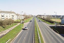
East Kilbride is a new town in Lanarkshire, taking the form of a large suburban town. Designated as Scotland's first new town in 1947, it forms part of the Greater Glasgow conurbation. The area lies on high ground on the south side of the Cathkin Braes, about 8 miles southeast of Glasgow city centre and close to the boundary with Renfrewshire.
Contents
The lie of the land
The town is enclosed by the White Cart River to the west and the Rotten Calder to the east, the latter flowing northwards to join the River Clyde near Cambuslang. This area was previously the site of the small and historic village of East Kilbride, before its post-war development. The modern settlement serves both as a dormitory town for the city of Glasgow and maintains its own commercial centre.
By East Kilbride is Calderglen, a river valley which, apart from the Avon Gorge, is unique in its bearing, for while a hillside river may be expected to be born a narrow, fast-flowing burn with steep cliffs, lower down to mature into a slow, meandering river of the plains, the Rotten Calder in Calderglen ages backwards: it rises in plains on the high ground and has a slow, meandering course, but then descends into the glen, forging a narrow channel running rapid between steep cliffs.
Calderglen was in the past celebrated as a picturesque wooded valley. It was the home of a noble family known as the Maxwells of Calderwood who resided in Calderwood Castle. The remnants of Calderwood Castle were demolished in 1951. A few parts of the structure remain.
History
The earliest evidence of habitation in the area dates back to ancient graves found near the Kype Water to the south of the district. Roman coins and footwear have also been found in the area.
East Kilbride takes its name from an Irish saint, St Bride (or Brigit) who founded a monastery for nuns and monks in Kildare in Ireland in the 6th century. Irish monks introduced her order to Scotland. Kil, from the Irish cill, means church or burial place, ultimately from the same root as "cell".
The original parish church stood on the site of a well, which is possibly the origin of the association with St Brigit, since such wells were on occasion dedicated to the Celtic goddess of the same name, whose traditions the reverence of St Brigit continued. Over the centuries the church has been destroyed and rebuilt several times. As a result, its current location has moved from its original site by about 50 yards.
East Kilbride grew from a small village of around 900 inhabitants in 1930 to become eventually a large burgh. Behind this growth lay the rapid industrialisation of the nineteenth century which left much of the working population throughout Scotland's central belt from Glasgow to Edinburgh living in the housing stock built at the end of that century but accommodating far more people. The Great War postponed any better housing as did the Treaty of Versailles and the period of post war settlement it created. In turn this was followed by the Great Depression. After the Second World War, Glasgow, already suffering from chronic shortages of housing, had to deal with bomb damage from the war.
From this unlikely backdrop a new dawn emerged which would bring East Kilbride to its unlikely success. In 1946 the Greater Glasgow Regional Plan allocated sites where overspill satellite "new towns" could be constructed to help alleviate the housing shortage.[1] Glasgow would also undertake the development of its peripheral housing estates. East Kilbride was the first of five new towns in Scotland to be designated, in 1947, followed by Glenrothes (1948), Cumbernauld (1956), Livingston (1962) and Irvine (1964).[2]
The town has been subdivided into residential precincts, each with its own local shops, primary schools and community facilities. The housing precincts surround the shopping centre, which is bound by a ringroad. Industrial estates are concentrated at sites to the north, west and south, on the outskirts of the town.
Economy
The town centre is occupied by a large shopping centre comprising 6 linked malls, developed in phases. The malls are known by local residents as "The Centre".
The six malls are The Plaza (development started in 1972), Princes Mall (1984), Olympia (1988), Southgate (1989), Princes Square (1997) and Centre West (2003). The shopping centre has come under recent criticism for losing major retail chains in light of rising rental prices. This coupled with the Centre West expansion and decreasing shopper numbers has allowed swathes of properties within the centre to remain closed for months at a time, notably on the first floor of Centre West and the Plaza.
A £400m redevelopment of East Kilbride town centre has been given the go-ahead by South Lanarkshire Council. The plan would demolish some existing buildings to create a new civic centre, a state-of-the-art health centre, a library and shopping facilities.[3][4]
It would also see a "landmark" arts and culture complex with a 1,000-seat theatre, a 500-seat conference centre, a museum and a new town square.
Parking spaces in the town centre would increase from 3,000 to 8,700 spaces. The first stage of the plan was due to start in 2006, with completion of the major elements in 2012/2013, but the project has been indefinitely delayed. It is hoped the project, the various phases of which will require full planning permission, will create up to 3,000 temporary jobs over the 10-year construction programme and 2,000 permanent jobs.
The new civic and health facilities would be created at the site currently occupied by Plaza Tower, which would be demolished, with the theatre and arts facilities being created at the adjoining Olympia Centre.
The current civic centre and the adjoining Hunter Health Centre would be demolished to make way for the first phase of development, which would include a major food retail store.
There is to be a relocation of the Hunter Health Center to a more central area where consumers can access it.
Churches
Churches in East Kilbride include:[5]
- Church of Scotland:
- Claremont Parish Church
- Greenhills Parish Church
- Moncreiff Parish Church
- Mossneuk Parish
- Old Parish Church
- South Parish Church
- Stewartfield Parish Church
- West Kirk
- Westwood Kirk
- Free Presbyterian Church of Scotland: East Kilbride Free Church
- Scottish Episcopal Church: St Mark's
- Baptist:
- Independent / Evangelical:
- Church of Christ
- EK Third Day
- Congregational Church
- Cornerstone
- East Kilbride Brethren Meeting
- King’s Church
- Logos Christian Fellowship
- Threshold Assembly
- Westwoodhill Evangelical Church
- Lutheran: St Columba
- Methodist: St Andrew's
- Salvation Army East Kilbride
- Society of Friends (Quakers)
- United Reformed Church
- Roman Catholic:
- Our Lady of Lourdes
- St Bride's
- St Leonard's
- St Vincent de Paul
Landmarks
- Dollan Aqua Centre was one of the most significant buildings of an earlier phase of development was Dollan Baths leisure complex (opened 1968) which has Category-A listed status. The Dollan Baths are the subject of a local urban myth, which told that the pool was built 2 inches short of Olympic size. In actual fact, the pool was built as 55 yards long, but is only six lanes wide, rather than the Olympic standard of ten lanes wide. The Aqua Centre re-opened on May 28, 2011 after a major refurbishment.
- Hunter House Museum contains exhibits relating to medical pioneers, William and John Hunter, who were born in the area.
References
- ↑ http://www.theglasgowstory.com/story.php?id=TGSFG10
- ↑ Cowling, D. (1997). An Essay for Today: the Scottish New Towns 1947-1997. Edinburgh: Rutland Press.
- ↑ http://www.eastkilbride.org.uk/community/redeveloping-east-kilbridede.htm East Kilbride Town Centre redevelopment
- ↑ http://news.bbc.co.uk/1/hi/scotland/4870462.stm BBC News (2006) New town could get £400m facelift
- ↑ East Kilbride Church directory
Outside links
| ("Wikimedia Commons" has material about East Kilbride) |
- Interactive picture guide of East Kilbride
- East Kilbride's Shopping Centre
- Business and Community
- Community and Local Events
- East Kilbride Pirates American Football team
- Dynamica Drum Corps, East Kilbride
- Local News and Community Events


