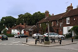
East Hoathly
| East Hoathly | |
| Sussex | |
|---|---|
 Public house in East Hoathly | |
| Location | |
| Grid reference: | TQ521161 |
| Location: | 50°55’28"N, 0°9’46"E |
| Data | |
| Population: | 1,600 (2011, with Halland) |
| Post town: | Lewes |
| Postcode: | BN8 |
| Dialling code: | 01825 |
| Local Government | |
| Council: | Wealden |
| Parliamentary constituency: |
Wealden |
| Website: | easthoathlywithhalland.org.uk |
East Hoathly is a village in Sussex. Two miles to the west is a similarly sized village, Halland. The village stands astride the A22 road, four miles north-west of Hailsham.
The origin of the village name is said to be from the family name of De Hodleigh, landowners in the 12th century.
The village was the home of Thomas Turner (1729–1793), a local diarist, in the 18th century.
A Decca Navigator transmitter station was located here, one of four that formed the 'English Chain 5B. Designated the Green station', with a base frequency of 127.500 kHz, its GPS location was 50.917°N, 00.150°E. John Pratt was the Station Master and he lived on site with his wife and daughters. After the closure the family moved to Hailsham. A combination of legal complications and the advent of the GPS system doomed Decca Navigator, which first saw service on D-Day and was used to guide ships ashore.
About the village
The parish church (which has no dedication) forms a united benefice with that at Chiddingly;[1][2] and there is a Church of England primary school in the village.[3]
The village pub is The Kings Head.
Society and sport
There is a village recreational area where tennis, cricket and football are played.
East Hoathly has its own bonfire society and holds a huge bonfire event each year around the 5 November.[4] Society members dress in an array of costumes ranging from cowboys and Indians, to Vikings and military personnel.
Outside links
| ("Wikimedia Commons" has material about East Hoathly) |