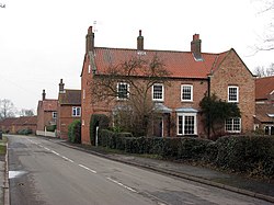
East Drayton
| East Drayton | |
| Nottinghamshire | |
|---|---|
 East Drayton | |
| Location | |
| Grid reference: | SK775751 |
| Location: | 53°15’36"N, 0°50’24"W |
| Data | |
| Population: | 252 (2011) |
| Post town: | Retforrd |
| Postcode: | DN22 |
| Local Government | |
| Council: | Bassetlaw |
| Parliamentary constituency: |
Newark |
East Drayton is a village in Nottinghamshire, in the east of the county close to the border of Lincolnshire, marked here by the tidal River Trent, three miles to the east, at Dunham-on-Trent.
The 2011 census recorded a population of 252,
The parish church, St Peter and St Paul, is of the 13th or 14th century in date.
History
East Drayton is recorded in the Domesday Book of 1086 as Draitone, as as being land belonging to the King, both before and after the Conquest.[1] The prefix 'East' distinguishes this village from the village of West Drayton, four miles west.
Nicholas Hawksmoor the architect was born in this village.[2]
A windmill was recorded at East Drayton in 1712, a post mill with a full width enclosed porch and porthole-like windows with shutters. It was possibly moved here from Lincolnshire.
About the village
The village has a pub, The Bluebell Inn.
The village sports club has a Saturday football team during the winter months and in the summer a Saturday and Sunday cricket team.
Outside links
| ("Wikimedia Commons" has material about East Drayton) |
References
- ↑ Drayton East Drayton in the Domesday Book
- ↑ Nikolaus Pevsner: The Buildings of England: Nottinghamshire, 1951; 1979 Penguin Books ISBN 978-0-300-09636-1