Difference between revisions of "East Creech"
From Wikishire
(Created page with "{{Infobox town |name=East Creech |county=Dorset |picture=Farm, East Creech - geograph.org.uk - 1523253.jpg |picture caption=East Creech Farm |os grid ref=SY928825 |latitude=50...") |
(No difference)
|
Latest revision as of 22:20, 26 May 2020
| East Creech | |
| Dorset | |
|---|---|
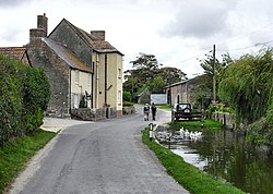
 East Creech Farm | |
| Location | |
| Grid reference: | SY928825 |
| Location: | 50°38’33"N, 2°6’11"W |
| Data | |
| Post town: | Wareham |
| Postcode: | BH20 |
| Dialling code: | 01929 |
| Local Government | |
| Council: | Dorset |
| Parliamentary constituency: |
South Dorset |
East Creech is a hamlet in the county of Dorset.
The hamlet sits at the northern foot of the Purbeck Hills about two miles west of Corfe Castle.
In 1224, East Creech Manor was in the possession of Walter Le Franke. It passed down through his family to Mary Franke, who in 1637 married Edmund Hayter (d.1657) and the manor was transferred to him. It remained in the Hayter family until 1770, when Samuel Hayter (1736-1800) sold up and moved to Wareham Priory.
