East Anton
| East Anton | |
| Hampshire | |
|---|---|
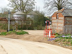
 Manor Farm, East Anton | |
| Location | |
| Grid reference: | SU391471 |
| Location: | 51°13’19"N, 1°26’29"W |
| Data | |
| Post town: | Andover |
| Postcode: | SP11 |
| Dialling code: | 01264 |
| Local Government | |
| Council: | Test Valley |
| Parliamentary constituency: |
North West Hampshire |
East Anton is a suburb and housing development of Andover in northern Hampshire. It is a mile and a half north-east of Andover itself. Formerly, it was a hamlet made up of two farms and related buildings.
History
Both the 1895 and 1969, maps indicate East Anton was a small, rural hamlet, made up of two farms; "East Anton Farm" and "Little East Anton Farm".[1] Additionally, "Redbrick Cottages" (now demolished) were located to the south, on the Icknield way.
East Anton remained isolated until the latter end of the 20th century with the continued rapid growth of Andover (as an overspill town, although later on from the initial plans) and the housing developments in the areas of Kingsway Gardens and Roman Way
Nonetheless, East Anton remained separate from Andover for some years, with the urban area stopping at the Icknield Way and agricultural land providing distance between the two settlements.
However, in 2008 development began, and in 2012 the land surrounding East Anton was declared a "Major Development Area" (MDA) with proposals for 2,500 houses, including 40% affordable housing.[2]
By 2019 a significant amount of development was complete, with a primary school,[3] a community centre, a sports ground and a new wood[4] all added. The development is not scheduled to be completed until 2028, although as of 2019, 1875 houses are occupied.[5]
Four buildings from the original East Anton hamlet are grade two listed; a granary, a barn, a farmhouse and the manor.
The entire development is known as 'Augusta Park'. 'Saxon Heights' and 'The Chariots' are sub-sections of the development.
References
- ↑ "East Anton Historic OS map". https://maps.nls.uk/geo/explore/spy/#zoom=16.171982435193264&lat=51.22814&lon=-1.47176&layers=193&b=1&r=30.
- ↑ "New Neighbourhoods in Test Valley". Test Valley District Council. 2012-04-13. http://www.testvalley.gov.uk/resident/housingandenvironmentalhealth/housing/housing-development/new-neighbourhoods-test-valley/.
- ↑ "New School in Augusta Park". https://www.andoveradvertiser.co.uk/news/15986799.hampshire-county-council-team-reveals-progress-new-east-anton-school/.
- ↑ "Trees in East Anton". https://www.andovertrees.org.uk/harmony-woods-history.
- ↑ "East Anton Information". https://www.testvalley.gov.uk/communityandleisure/my-local-area-new/andover-romans/augusta-park/east-anton-augusta-park-residents-survey-feedback.