Dundonald, County Down
| Dundonald | |
| County Down | |
|---|---|
_-_geograph.org.uk_-_791377.jpg) St Elizabeth's Church, Dundonald | |
| Location | |
| Location: | 54°35’38"N, 5°48’47"W |
| Data | |
| Population: | 13,900 (2001) |
| Post town: | Belfast |
| Postcode: | BT16 |
| Dialling code: | 028 |
| Local Government | |
| Council: | Lisburn and Castlereagh |
| Parliamentary constituency: |
Strangford |
Dundonald is a large settlement in County Down. It lies east of Belfast and is often deemed to be a suburb of the city. It includes the large housing estate of Ballybeen, and many new housing developments have emerged in the past ten years.
Contents
History
Dundonald refers to a 12th-century Norman fort, or Dún, Dún Dónaill, that stood in the town. One of the largest in Ireland, the man-made hill on which the fort stood still stands above the town. The hill is a motte, and commonly called 'the moat' locally. St. Elizabeth's Church stands beside the moat, with the Cleland Mausoleum in the adjacent graveyard.
Dundonald acquired rail links to Belfast and Newtownards in 1850, Downpatrick in 1859 and Newcastle in 1869. The rail link with Belfast encouraged Dundonald to expand as a commuter town, but in 1950 the railway line running through Dundonald was closed. Dundonald station was opened on 6 May 1850, but finally closed on 24 April 1950.[1]
Until the 1960s, Dundonald was a small village. A number of property developments, most notably the housing estate Ballybeen, were then built and Dundonald's population rapidly grew.
Townlands
Dundonald sprang up within the small parish of the same name which has long been divided into townlands, whose names mostly come from the Irish language. Over time, more rural townlands have been built upon and they have given their names to many roads and housing estates. The following is a list of townlands within Dundonald's urban area, alongside their likely etymologies, though their origins are as lost as the tongue from which they originally sprang:[2]
| Ballybeen | prob. Baile Binne; "townland of the peak" or Baile Bín; "Bín's townland" |
| Ballymiscaw | likely from Baile Lios na Scáth; "townland of the fort of shadows" |
| Ballyoran | likely from Baile Fhuaráin; "townland of the spring" |
| Ballyregan | likely from Baile Uí Riagáin; "Ó Riagáin's townland" |
| Carrowreagh | likely from an Cheathrú Riabhach; "the speckled quarterland" |
| Dunlady | likely from Dún Léide; "Léide's stronghold" |
Places of interest
A 300 year old watermill is located on the Belfast Road in the town. The sandstone building has been extensively restored and includes a brasserie, gift shop and a 35-foot waterwheel said to be the largest in Ireland.
The Comber Greenway is a direct traffic free link into Belfast and it passes through Dundonald. It is enjoyed by thousands of cyclists and walkers on a daily basis. This area of tranquility is currently under threat by the proposed rapid transport link into Belfast.
In 1986, The Dundonald International Ice Bowl was opened in the town. This originally comprised an Olympic sized ice rink and a 20 lane ten pin bowling alley. In later years, "Indianaland", a children's indoor adventure playground was added along with Laser Quest, a simulated combat arena using laser tag equipment. The bowling alley was upgraded to 30 lanes in the 1990s and an extensive miniature golf course has recently been built. The site also contains a fitness centre. In 2006, the area was designated as the Dundonald Leisure Park, as part of the Draft Belfast Metropolitan Area Plan 2015. In 2008, an Omniplex cinema was built on the opposite side of the Old Dundonald Road, together with several leisure and restaurant units.[3]
The Ulster Hospital is located in Dundonald, known colloquially as "The Ulster".
Sport
A number of local football teams play in the Down Area Winter Football League, "Dundonald FC" "Moat Park Rangers" and "43RD Old Boys" are the three clubs that are well known in the town.
The town's ice rink, the Dundonald Ice Bowl is home to the Junior Belfast Giants ice hockey team.
Ards TT
From 1928 to 1936, the RAC Tourist Trophy (TT) motorcar races took place on a (closed) road circuit encompassing Newtownards, Comber and Dundonald in County Down, run in a clockwise direction.[4] The pits were still visible up until the 1960s. A popular viewing point was the hairpin bend at the Central Bar in Dundonald.
Industrialist and pioneer of the modern agricultural tractor, Harry Ferguson, was instrumental in setting up the race, which was known as the Ards TT.
At the time, it was Ulster's premier sporting event, regularly attracting crowds in excess of a quarter of a million people. Although it was a speed event, the entries were handicapped in order to allow cars of very different sizes and capabilities to race against each other on supposedly even terms over 30 laps (35 laps from 1933) of the 13.7 mile circuit.
On 5 September 1936, in wet conditions, local driver Jack Chambers lost control of his Riley and crashed into the crowd, killing eight spectators. This tragedy brought an end to nine years of racing over the Ards road circuit.[4][5]
Pictures
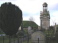
The Cleland Mausoleum in St. Elizabeth's Churchyard, with the Moat in the background.
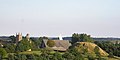
The Moat.
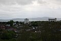
View of Dundonald from The Moat, Belfast in the distance.

The former National School (now part of Dundonald Presbyterian Church), Church Green, built in 1844.


Outside links
| ("Wikimedia Commons" has material about Dundonald, County Down) |
References
- ↑ "Dundonald station". Railscot - Irish Railways. http://www.railscot.co.uk/Ireland/Irish_railways.pdf. Retrieved 2007-09-05.
- ↑ "Northern Ireland Placenames Project". http://www.placenamesni.org/Index.html. Retrieved 2010-06-12.
- ↑ Castlereagh Borough Council
- ↑ 4.0 4.1 "The Tourist Trophy Races". Culture Northern Ireland. http://www.culturenorthernireland.org/article.aspx?art_id=838. Retrieved 2009-10-09.
- ↑ "Memorial revives Ards TT memories". BBC. 2008-08-18. http://news.bbc.co.uk/1/hi/northern_ireland/7567063.stm. Retrieved 2009-01-05.