Drayton, Norfolk
| Drayton | |
| Norfolk | |
|---|---|
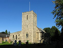
 St Margaret, Drayton | |
| Location | |
| Grid reference: | TG185135 |
| Location: | 52°40’30"N, 1°13’30"E |
| Data | |
| Population: | 5,489 (2011) |
| Post town: | Norwich |
| Postcode: | NR8 |
| Dialling code: | 01603 |
| Local Government | |
| Council: | Broadland |
| Parliamentary constituency: |
Norwich North |
Drayton is a suburban village in Norfolk, four and a half miles north-west of Norwich, on the A1067 road between Hellesdon and Taverham. Today, Drayton is largely dominated by the Thorpe Marriott housing estate built in the late twentieth century.
History
Drayton's name is of Anglo-Saxon origin and derives from the Old English for a farmstead or settlement where logs were dragged.[1]
In the early twentieth century, several Roman artefacts including coins and pottery were unearthed close to the village with a further Anglo-Saxon cemetery being discovered on the banks of the nearby River Wensum. The cemetery has yielded Anglo-Saxon brooches, daggers and pottery.[2]
In the Domesday Book, Drayton is listed as a settlement of ten households. In 1086, the village was part of the estates of Ralph de Beaufour.[3]
Throughout the mid-fifteenth century, Drayton was part of the estates of Sir John Fastolf, a prominent English soldier in the Hundred Years War and whose name, though not character, was the basis of Shakespeare's Sir John Falstaff. Fastolf built Drayton Lodge in 1437 as a fortification overlooking the Wensum. By the time of Falstolf's death in 1459, his estates passed into the hands of John Paston which was fiercely contested by John de la Pole, Duke of Suffolk whose estates consisted of the neighbouring village of Costessey. The clashes resulting from the dispute are documented in the Paston Letters. Though Drayton Lodge was partly demolished in 1465, the ruins are still visible today.
Drayton railway station opened in 1882 as a stop on the Midland and Great Northern Joint Railway route between Melton Constable and Norwich. The station was closed in 1959 and today the route forms part of Marriott's Way, the long-distance foot and cyclepath between Norwich and Aylsham.
To the west of Drayton is a rare example of a private fallout shelter built to Government specification during the Cold War.[4]
Churches
Drayton's parish church, St Margaret of Scotland, is of uncertain Mediæval origin. St. Margaret's was heavily remodelled in the nineteenth century, a process made necessary by the church tower collapsing into the nave in 1850. The church displays good examples of Continental stained glass depicting Anna the Prophetess, Mary and St Elizabeth.[5]
Amenities
Drayton has a petrol station (all night), Barclays Bank, estate agent, two post offices, butcher, doctors’ surgery and late night pharmacy, Lloyd's chemist, a Dental practice, baker, patisserie, florist, four hairdressers, beautician, dress shop, two industrial estates and several public houses including the Cock Inn and the Red Lion, and Stower Grange hotel and restaurant. It also has three Tesco outlets.
The village also has the Longdale and King George V playing fields, the Bob Carter Sports and Community Centre
Outside links
| ("Wikimedia Commons" has material about Drayton, Norfolk) |
References
- ↑ University of Nottingham. (2022). Retrieved December 25, 2022. http://kepn.nottingham.ac.uk/map/place/Norfolk/Drayton
- ↑ Robertson, D. (2006). Retrieved December 25, 2022. https://www.heritage.norfolk.gov.uk/record-details?TNF127
- ↑ Drayton, Norfolk in the Domesday Book
- ↑ Robertson, D. (2006). Retrieved December 25, 2022. https://www.heritage.norfolk.gov.uk/record-details?TNF127
- ↑ Knott, S. (2009). Retrieved December 25, 2022. http://www.norfolkchurches.co.uk/drayton/drayton.htm