Dartford
| Dartford | |
| Kent | |
|---|---|
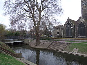
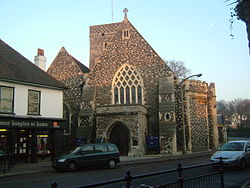 Holy Trinity Church, Dartford High Street | |
| Location | |
| Grid reference: | TQ538739 |
| Location: | 51°27’50"N, 0°15’14"E |
| Data | |
| Population: | 85,911 (2001) |
| Post town: | Dartford |
| Postcode: | DA |
| Dialling code: | 01322 |
| Local Government | |
| Council: | Dartford |
| Parliamentary constituency: |
Dartford |
Dartford is a sizable town in northern Kent.
The town centre is situated in a valley through which the River Darent flows, and where the old road from London to Dover crossed: hence the name, from Darent ford. Dartford became a market town in the Middle Ages and, although today it is principally a commuter town for London, it has a long history of religious, industrial and cultural importance. It is an important rail hub; the main through-road now avoids the town itself.
Contents
History
The earliest of mankind who have left traces in the Dartford area were Palaeolithic peoples of around 250,000 years ago: a tribe of prehistoric hunter-gatherers whose exemplar is called Swanscombe Man. Many other archaeological investigations have revealed a good picture of occupation of the district with important finds from the Stone Age, the Bronze Age and the Iron Age.
When the Romans engineered the Dover to London road (afterwards named Watling Street) it was necessary to cross the River Darent by ford, giving the settlement its name. Roman villas were built along the Darent valley, and at Noviomagus (Crayford), close by. The Jutes may have established the first settlement where Dartford now stands.
The Domesday Book of 1086, written after the Norman conquest, records that the manor of Dartford was owned by the king.
During the Middle Ages Dartford was an important waypoint for pilgrims and travellers on the way to Canterbury and Europe, and various religious orders established themselves in the area. In the 12th century the Knights Templar had possession of the manor of Dartford;[1] the National Trust property at Sutton-at-Hone, to the south of the town, is a remaining piece of that history. In the 14th century, a priory was established here, and two groups of friars (the Dominicans and the Franciscans) built hospitals here for the care of the sick. At this time the town became a small but important market town.
Dartford claims to be the hometown of Wat Tyler, leader of the 1381 Peasants' Revolt, although three other towns in Kent all claim the same.
In the 15th century, King Henry V]] marched through the town in November 1415 with his troops to invade France, leading to the victory at the Battle of Agincourt. In 1422 though Henry's body was taken to Holy Trinity Church by Edmund Lacey, Bishop of Exeter, who performed his funeral mass. In March 1452, Richard Duke of York camped on the Brent with ten thousand men, waiting for a confrontation with King Henry VI. The Duke surrendered to the King in Dartford. The place of the camp is marked today by York Road.
The sixteenth century saw significant changes to the hitherto agricultural basis of the market in Dartford, as new industries began to take shape (see below). The priory was destroyed in 1538 as part of the Dissolution of the Monasteries and a new manor house constructed by King Henry VIII. In 1576 Dartford Grammar School was founded, part of the Tudor emphasis on education for ordinary people.
Many Protestants were executed during the reigns of Bloody Mary (1553–1554), including Christopher Waid, a Dartford linen-weaver who was burnt at the stake in front of thousands of spectators on the Brent in 1555. The Martyrs Memorial on East Hill commemorates Waid and other Kentish Martyrs.
Industrial history
The earliest industries were those connected with agriculture, such as the brewing of traditional beers and ales. Lime-burning and chalk-mining also had their place. Fulling was another: the cleansing of wool needed a great deal of water, which the river could provide. This led to other water-based industries, using hydropower to operate machinery.
Sir John Spilman set up the first paper mill in Britain at Dartford in 1588 on a site near Powder Mill Lane, and soon some 600 employees worked there, providing an invaluable source of local employment. The Weald was busy with ironworking at this time, and iron ingots were sent to Dartford, to Britain's first iron-slitting mill, set up by the Darent at Dartford Creek in 1595 by Godfrey Box, an immigrant from the Low Countries. In 1785, a blacksmith from Lowfield Street began to make engines, boilers and machinery. Some of that machinery was for the local gunpowder factory run by Miles Peter Andrews and the Pigou family. In 1785, the firm of J & E Hall was set up, specialising in heavy engineering, and later refrigerating equipment, and, by 1906, vehicle building.
From those beginnings in the 18th century was to come the industrial base on which the growth and prosperity of Dartford were founded.
In 1840 the mustard factory of Saunders & Harrison was described as being 'perhaps the largest in the kingdom'.[2] Dartford Paper Mills were built in 1862, when excise duty on paper was abolished. Between 1844-1939 the fabric printing works of Augustus Applegath were in being in Bullace Lane: again a firm using the waters of the river.
The demand created by First World War meant that output at the local Vickers factory multiplied, with a positive effect on the local economy. Burroughs-Wellcome chemical works (later incorporated into GlaxoSmithKline) made Dartford a centre for the pharmaceutical industry. During the war, many Belgian refugees arrived in the town. Unable to accommodate them all, many people were housed with volunteers.
There has been a large power station at Littlebrook on the Thames, to the north of the town, since 1939. The current station, which features one of the tallest chimneys in Britain, dates from about 1978.
The Mazda motor manufacturer has its UK head office at the large Thames-side Crossways Business Park.
In early 2006 the South East England Development Agency (SEEDA) purchased a 2.6 hectare site on the edge of the town which had been used by Unwins, an off licence chain that went into administration in 2005. They also purchased the neighbouring Matrix Business Centre to protect its future. They intend to develop the site as 'Dartford Northern Gateway' with a mixture of retail and other businesses and housing.
Geography
Dartford lies within the area known as the London Basin. The low-lying marsh to the north of the town consists of London Clay, and the alluvium brought down by the two rivers - the Darent and the Cray - whose confluence is in this area. The higher land on which the town stands, and through which the narrow Darent valley runs, consists of chalk surmounted by the Blackheath Beds of sand and gravel.
Dartford was established at a river crossing-point with the coming of the Romans; and as a focal point between two routes - that from west to east being part of the main route connecting London with the Continent; and the southerly route following the Darent valley. As a result, the town's main road pattern makes the shape of letter 'T'. The Dartford Marshes to the north, and the proximity of Crayford to the west, mean that the town's growth is to the south and east. Wilmington is to all intents and purposes part of the town to the south; whilst the almost continuous "Thames Gateway" development means that there is little to show the town boundary in an easterly direction.
Dartford Heath
Dartford Heath spreads out to the south-west of Dartford, covering some 314 acres of open space. Historically it has always been of importance: prehistoric barrows and Bronze Age artefacts having been discovered here. The first recorded cricket match took place here in 1723; and the Society of Royal Kentish Bowman were briefly established here between 1785-1802. The nearby area is still known as Bowmans.
The Heath is an official Area of Outstanding Natural Beauty. It contains three ponds (Donkey Pond, Woodland Pond and North Pond) and a variety of habitats: including acid grassland, broadleaved semi-natural woodland, heather and gorse, as well as other plant life.[3] It is common land and therefore escaped being enclosed during the late 18th and the early 19th centuries. It is also the original source for the name of the Dartford Warbler. Dartford Heath is used as a local recreation and dog walking area, but suffers from being close to the local recycling centre which sometimes leaves windblown rubbish along proximal roads.
Churches
The Parish Church, Holy Trinity, is situated on the western bank of the River Darent, from where a hermit would conduct travellers across the ford. The church was originally a 9th-century Saxon structure, but gained later Norman additions. In the 13th century a Royal Wedding was celebrated there, thus today the choristers are entitled to wear scarlet cassocks. Also on display within the church is a brass plaque commemorating the work of Richard Trevithick, the pioneer of steam propulsion, who lived, worked and died in the town.
The graveyard is situated in St Edmund's Pleasance on the summit of East Hill (the place Richard Trevithick is buried), which gave rise to a traditional and derogatory rhyme of Dartford's people 'Dirty Dartford, Stinking People, bury their dead above the steeple'. The church actually has no steeple; it has a tower featuring a ring of eight bells.
Culture and community
- The Orchard Theatre, located in the town centre, is a fully professional theatre, providing audiences with a large range of drama, dance, music and entertainment.
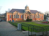
- The Mick Jagger Centre (built in the grounds of Dartford Grammar School) in Shepherds Lane was completed in 2000 and provides facilities for community arts across a wide region. The local museum in Market Street is housed in the same building as the library.
- Central Park is a formal park in the town centre covering 26 acres.
Transport
The route of a Celtic ancient trackway which the Romans later paved and identified as Iter III on the Antonine Itinerary, later to be called Watling Street, and which the current A2 roughly follows, passed close to the town. After the Romans left Britain, it fell out of use, as the town itself developed and traffic went into the town itself, the name Watling Street transferring to the new route. The introduction of stagecoach services increased the amount of traffic through the town, so that by the 18th century it had become necessary to control the upkeep of such a heavily-used road. Turnpike Trusts were set up by Act of Parliament. Dartford was served by two: that for Watling Street; and the road south to Sevenoaks, both brought into being between 1750 and 1780.
By Dartford is the lowest bridge on the River Thames; the Queen Elizabeth II Bridge spans the Thames here, opened in 1991. The northbound carriageway crosses via the twin bore Dartford Tunnel. The first tunnel was opened in 1963, its twin in 1980.[4]
Dartford railway station is a busy junction serving three routes. The first railway from London to reach Dartford was the North Kent Line via Woolwich in 1849, connecting at Gravesend with the line through to the Medway Towns. Later two more lines were built, the Dartford Loop Line through Sidcup, which opened in 1866, and the Bexleyheath Line which opened in 1895. All the lines were electrified on 6 June 1926.
Outside links
| ("Wikimedia Commons" has material about Dartford) |
References
- ↑ House of Knights Templar - The preceptory of Ewell | British History Online
- ↑ 'Pigots 1840', on website freepages.genealogy.rootsweb.com/~shebra/pigots_1840 accessed 5 December 2007
- ↑ Guardian gallery of heathland in danger
- ↑ "Highways Agency - The Dartford - Thurrock River Crossing". Dartfordrivercrossing.co.uk. 2009-09-13. http://www.dartfordrivercrossing.co.uk/drc/hist.htm. Retrieved 2011-03-13.
Books
- Kent History Illustrated - Frank W Jessup (KCC, 1966)
- Railways of the Southern Region - Geoffrey Body (PSL Field Guide 1989)
- Local History - Mark Chatwin (1997)
