Darby Green
| Darby Green | |
| Hampshire | |
|---|---|
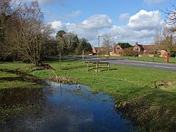
 The village pond in Darby Green | |
| Location | |
| Grid reference: | SU837603 |
| Location: | 51°20’11"N, 0°47’55"W |
| Data | |
| Post town: | Yateley |
| Postcode: | GU17 |
| Local Government | |
| Council: | Hart |
| Parliamentary constituency: |
North East Hampshire |
Darby Green is a village in the parish of Yateley in the very north-east of Hampshire, attached to the conurbation that spreads along the River Blackwater and the borders of Hampshire with Surrey and Berkshire.
Darby Green is joined without break to Frogmore to the east, and separated by a narrow green gap from Yately to the east. To the north is the Blackwater, and across it Sandhurst in Berkshire
The village is named after Parson Darby, who was a local vicar and a highwayman; he was supposedly hung at the junction of the B3272 and Darby Green Road. The historian Sidney Loader was a resident of Yateley and lived near this spot.
There used to be a tin church at the corner of the B3272 named for St Barnabas. This burned down in the 1980s and was replaced by a new St Barnabas in Bell Lane, close to Frogmore Green. Every year, close to St Barnabas Day in June, the Church organises a community fair.
Outside links
| ("Wikimedia Commons" has material about Darby Green) |