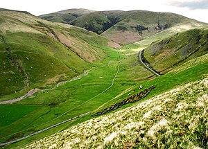
Dalveen Pass
The Dalveen Pass is an important mountain pass through the Lowther Hills connecting Nithsdale in Dumfriesshire to Clydesdale in Lanarkshire.
The Dalveen Pass has been an important route since ancient times. A Roman road runs through the northern end of the pass, and today it is used by the A702 Nithsdale to Edinburgh road.
The route from the south follows up the Carron Water, a tributary of the River Nith, whose main source stream is the Dalveen Lane. The Dalveen Lane carves a steep dale through the Lowther Hills, which gives a name to the Dalveen Pass, seen at its best here high in the hills. The head of the pass is at the county border, which is formed by the watershed between the Nith basin, draining south to the Solway Firth, and the Clyde, draining north to the Firth of Clyde.
The Roman road leaves Nithsdale lower down, and heads up an alternative pass, through Durisdeer and up the Kirk Burn; the remains of a Roman fortlet are to be found below Durisdeer Hill. The head of this pass likewise is at the watershed on the county border, from where the Roman road heads north to join the Dalveen Pass.
North of the watershed the pass is in Lanarkshire. The route follows the Potrail Water east then north, down to Watermeetings, where the Potrail Water the Daer Water join to create the River Clyde.
