Dalston, Cumberland
| Dalston | |
| Cumberland | |
|---|---|
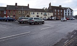
 The Square at Dalston | |
| Location | |
| Grid reference: | NY395555 |
| Location: | 54°53’28"N, 2°56’38"W |
| Data | |
| Population: | 2,578 |
| Post town: | Carlisle |
| Postcode: | CA1-CA6 |
| Dialling code: | 01228 |
| Local Government | |
| Council: | Cumberland |
| Parliamentary constituency: |
Carlisle |
Dalston is a large village in northern Cumberland, close to Carlisle. It is to be found on the B5299 road about four miles south of Carlisle city centre, and approximately five miles from Junction 42 of the M6 motorway.
The village has a population of around 2500, and serves as a key service centre for a much wider rural area. At the centre is The Square, which is, in fact, not square. It is dominated by St Michael's and All Angels Church. Most of the shops are located in and around The Square. To the northwest of the centre of the village is the Barras Lane business estate which is home to numerous businesses.
The village is on the River Caldew and is served by the Dalston railway station on the coastal line between Carlisle, Workington and Barrow in Furness, taking over two hours for the full journey. There are two popular schools in Dalston, St Michaels Primary School and Caldew Secondary School which has over a thousand pupils. There is also a Nestlé factory producing powdered milk, a BP fuel depot and a factory producing specialist materials called Cowens.
About the village
Rose Castle
Rose Castle, home to the Bishop of Carlisle for many centuries until 2009, is within the Parish of Dalston a mile and a half from Dalston itself. The Architects Anthony Salvin and Thomas Rickman were responsible for the alterations which took place in the 19th Century
Dalston Hall
Dalston Hall is a grade II* listed fortified house dating from the late 15th century. It has been substantially extended and remodelled since then and is now a country house hotel.[1]
The hall was built c.1500 by John Dalston and incorporated a Pele tower and a baronial hall. An inscription below the parapet says JOHN DALLSTON ELSABET MI WYF MAD YS BYLDYNG. A west wing was added in 1556.
The house remained in the possession of the Dalston family for many generations, of whom several were sheriffs and MPs for the county of Cumberland. During the Civil War, Sir George Dalston had to leave when the house was occupied by Royalist troops under General David Leslie, Lord Newark.
Monkhouse Davison, a London grocer, bought the hall in 1761 from Sir George Dalston, Bt and owned it for 32 years until his death. In 1897 the hall was acquired by Edmund Wright Stead, owner and director of Stead McAlpin, calico printers, who commissioned the architect C J Ferguson to remodel the frontage in red sandstone in 1899. More recently the hall has been used as a youth training centre and in 1971 was converted into the present country house hotel.[2] It is now surrounded by a golf course.
Outside links
| ("Wikimedia Commons" has material about Dalston, Cumberland) |
References
- ↑ Dalston, Cumberland - British Listed Buildings
- ↑ "Dalston Hall – Carlisle". http://www.somethingparanormal.co.uk/dalston-hall/. Retrieved 10 September 2013.