Cuxwold
| Cuxwold | |
| Lincolnshire | |
|---|---|
 Church of St Nicholas, Cuxwold | |
| Location | |
| Grid reference: | TA172011 |
| Location: | 53°29’38"N, 0°14’3"W |
| Data | |
| Post town: | Market Rasen |
| Postcode: | LN7 |
| Local Government | |
| Council: | West Lindsey |
| Parliamentary constituency: |
Gainsborough |
Cuxwold is a village in Lindsey, the northern part of Lincolnshire, a mile south of of Swallow (to whose civil parish it has been allocated) and north-east of Rothwell. It lies in the Lincolnshire Wolds, four miles east of Caistor and ten miles south-west of Grimsby.
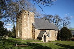
The parish church, St Nicholas. Is of 11th-century origin but with an incorporated earlier Anglo-Saxon tower arch. It was considerably restored and rebuilt in 1860 by James Fowler.[1][2] The restoration was carried-out under instruction from Henry Thorold, who, in the 1870s, added a monument to his family within the church. The church is a Grade II* listed building.[3]
Within the village another notable building is Cuxwold Hall, built in 1860.[4]
Cuxwold was the location of an emergency landing ground for airplanes during the Second World War and is now the home of Grimsby Airfield.
Outside links
| ("Wikimedia Commons" has material about Cuxwold) |
References
- ↑ Cox, J. Charles (1916) Lincolnshire p. 114; Methuen & Co. Ltd
- ↑ Kelly's Directory of Lincolnshire with the port of Hull 1885, p. 375
- ↑ National Heritage List 1165350: Church of St Nicholas (Grade II* listing)
- ↑ National Heritage List 1063506: Cuxwold Hall (Grade II listing)