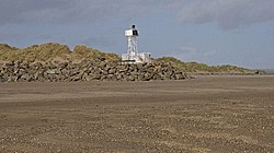
Crow Point Lighthouse
| Crow Point Lighthouse | |
 Crow Point Lighthouse | |
|---|---|
| Location | |
| Grid reference: | SS46663193 |
| Location: | 51°3’58"N, 4°11’23"W |
| Characteristics | |
| Height: | 16 feet |
| Tower shape: | square pyramidal tower with balcony and light |
| Tower marking: | White tower |
| Light: | Fl WR 2.5s. |
| Intensity: | 182 candela |
| Focal height: | 25 feet |
| Range: | 6 nautical miles |
| History | |
| Built 1954 | |
| Information | |
| Owned by: | Trinity House |
Crow Point Lighthouse stands amongst the sands at the south end of Braunton Burrows on the north coast of Devon, and guides vessels navigating the Taw and Torridge estuary.
Built in 1954, the lighthouse is a small tubular steel structure, powered when first built by acetylene gas, then from 1978 by electricity and now by solar power following conversion in 1987.[1] It was modernised in 2001,[2] and currently displays a sector light indicating safe passage in and out of the River Taw. The light is operated by Trinity House.
Bideford Bar leading lights
A much larger structure formerly stood, alongside the estuary, north-west of the current light: Bideford High lighthouse (also known as Braunton Lighthouse) consisted of an octagonal wooden tower built on top of keepers' accommodation, 86 foot high in total.[3] There was also an associated low light.[4] The low light was 300 metres to the north-west of the main light; when the two were aligned, as seen from a vessel in Bideford Bay, they provided a bearing for the safe passage through the shoals in the estuary.[5] The lower light was contained in a wooden shed mounted on a short railway running perpendicular to the shore, so that it could be moved to keep pace with the dynamically shifting shoals; for example, between 1820 and 1832 it had to be winched 34 m to the north-east, while in the following twelve years it had to be winched back to the south-west by 90Template:Nbspm.[6] Designed by Joseph Nelson, both lighthouses were built in 1819 and came into use the following year; both were painted white and each was lit by a single Argand light mounted within a parabolic reflector.[5] The Low Light was rebuilt in 1832. In the 19th century the lights were tidal: rather than being lit all night, they were only displayed between half-flood and half-ebb, when they signalled safe passage over Bideford Bar[5] (a notorious sand bank which renders entry into the Taw Torridge Estuary hazardous at low tide).[7]
In 1879 the High Light began to be displayed all night, regardless of the state of the tide.[8] This was one of a number of improvements undertaken to the light in association with the establishment of Bull Point Lighthouse further to the north. It was around this time that a lantern was added to the top of the tower (transplanted from one of the decommissioned Casquets lighthouse towers)[9] and the light was made dioptric. At the same time the visible arc of the light was increased to seaward (and in addition it was made visible, as a less powerful light, to the south and east for harbour navigation).[8] Not long afterwards, in 1889, the High Light was made occulting (the light being eclipsed for two seconds every thirty seconds).[10] The Low Light remained tidal (later an additional red or green light signalled the state of the tide, and a spherical daymark was used during hours of daylight).[11] In 1890 each lighthouse was painted with a vertical red stripe on the seaward side.[12]
In 1945 the two lighthouse keepers were withdrawn as the ground under the High Light (where they lived) was becoming unstable. Plans were put in place for the High Light tower to be replaced and for both lights to be equipped with acetylene lamps (which would not require a keeper in full-time attendance). However the structure remained in use for a further 12 years. Latterly both lights were classed as 'unwatched', and they displayed occulting lights.[13]
After the establishment of Crow Point Light, both the old Braunton lights were demolished in 1957 and a new pair of leading lights were erected east of the estuary, at Instow.
References
- ↑ "Crow Point Lighthouse". Trinity House. http://www.trinityhouse.co.uk/lighthouses/lighthouse_list/crow_point.html.
- ↑ Woodman, Richard; Wilson, Jane (2002). The Lighthouses of Trinity House. Bradford-on-Avon, Wilts.: Thomas Reed. p. 207.
- ↑ High Light photo (Braunton Museum)
- ↑ Low Light photo (Braunton Museum)
- ↑ 5.0 5.1 5.2 "Lighthouse management : the report of the Royal Commissioners on Lights, Buoys, and Beacons, 1861, examined and refuted Vol. 2". 1861. pp. 94. https://archive.org/stream/lighthousemanage02blak#page/94/mode/1up.
- ↑ Keene, Janet; Keene, Peter (1997). Northam Burrows estuary environments.. Thematic Trails. p. 18. ISBN 978-0-948444-33-3.
- ↑ "Explore Braunton". http://www.explorebraunton.org/bideford-bar.aspx.
- ↑ 8.0 8.1 London Gazette, Issue 24747, Page 4701, 29 July 1879
- ↑ Mercantile Marine Fund: Minutes of Evidence Taken Before the Committee of Inquiry appointed by the President of the Board of Trade. London: HMSO. 1896. p. 281.
- ↑ London Gazette, Issue 25957, Page 4017, 26 July 1889
- ↑ "Braunton Lighthouse". https://www.mycetes.co.uk/a/page42.html.
- ↑ London Gazette, Issue 26115, Page 7057, 16 December 1890
- ↑ "British Isles, English Channel and North Sea". United States Hydrographic Office List of Lights and Fog Signals IV (33): 132. 1956.
- Rowlett, Russ: Lighthouses of Southwest England (Devon and Cornwall) – The Lighthouse Directory (University of North Carolina at Chapel Hill)
| Lighthouses of Trinity House |
|---|
|
Great Britain: |
| Channel Islands and Gibraltar: Casquets • Europa Point • Les Hanois • Sark |
