Crosskeys
| Crosskeys | |
| Monmouthshire | |
|---|---|
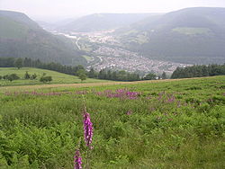
 View of Crosskeys | |
| Location | |
| Grid reference: | ST225915 |
| Location: | 51°37’8"N, 3°7’37"W |
| Data | |
| Population: | 3,265 |
| Post town: | Newport |
| Postcode: | NP11 |
| Dialling code: | 01495 |
| Local Government | |
| Council: | Caerphilly |
| Parliamentary constituency: |
Islwyn |
Crosskeys is a small village in the western valley of Monmouthshire.
Location
Crosskeys is seven miles north west of Newport, merging with Risca. It is located near to the confluence of the Ebbw River and the Sirhowy River. The name 'Crosskeys' is taken from the name of the local hotel.[1]
History and amenities
Crosskeys was once part of the coal mining community of the South Wales coalfield, but is now a quiet area complete with a residents' society. It has a large park in the lower part and listed buildings in neighbouring Pontywaun, which is normally considered as part of Crosskeys.
Many of the secondary school pupils attend nearby Cwmcarn High School. It is also home to a Further Education campus.
There is a local rugby union team, Cross Keys RFC, and consequently many different age-banded teams such as youth and mini rugby.
Crosskeys is close to the Cwmcarn Forest Drive which has extensive mountain-biking trails. There is a large local park toward the lower part of the village. The park is home to the local cricket club, again with age-banded youth teams as well as the men's team. There is also a park and a multiple-sports facility.
Sirhowy Valley Country Park is also easily accessible from Crosskeys. It is a base for walking or cycling with access to Flatwoods Meadows Local Nature Reserve. There is also mountain bike trails, a traditional working hill farm that is open to school visits and a small farm trail. Nearby Craig Coch is an ancient mixed woodland.
References
- ↑ The Welsh Academy Encyclopaedia of Wales page 178, John Davies, Nigel Jenkins, Menna Baines and Peredur Lynch (2008) ISBN 978-0-7083-1953-6
Outside links
- Crosskeys website has many pictures of the area.
- Cross Keys Silver Band The Cross Keys Silver Band Official Website.
- Welsh Coal Mines - every pit, all the history
- Crosskeys Rugby Football Club website All you need to know about Cross Keys RFC.