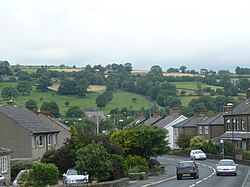
Cross Hills
| Cross Hills | |
| Yorkshire West Riding | |
|---|---|
 Street in Cross Hills | |
| Location | |
| Grid reference: | SE013449 |
| Location: | 53°54’4"N, 1°58’56"W |
| Data | |
| Post town: | Keighley |
| Postcode: | BD20 |
| Dialling code: | 01535 |
| Local Government | |
| Council: | North Yorkshire |
| Parliamentary constituency: |
Skipton and Ripon |
Cross Hills is a village in the West Riding of Yorkshire, sitting halfway between Skipton and Keighley. The village is at the centre of a built-up area that includes the adjoining settlements of Glusburn, Kildwick, Eastburn and Sutton-in-Craven.
Geography
Cross Hills is in Airedale at a point where the River Aire bends east from its north–south course. The village lies on the south bank of the river just above the flood plain, which is wholly agricultural. As its name implies, Cross Hills is surrounded by the hills of the eastern Pennines including Steeton Moor (south-east), Cowling Moor (south-west), White Hill (north-west) and Kildwick Moor (north-east). There are views along the Aire Valley itself to the north and east. Rombalds Moor, between Silsden and Ilkley, is about six miles east of Cross Hills. Skipton is about four miles north and the hills of the Yorkshire Dales can be seen beyond it.
Immediately south-west of Cross Hills is Glusburn. Due north, on the other side of the River Aire is Kildwick. Sutton-in-Craven is less than a mile to the south-west and Eastburn less than a mile to the south-east. Cross Hills is separated from Sutton-in-Craven and Eastburn by the beck which flows into the Aire just east of Cross Hills. The beck is known by various names: Surgill Beck, Holme Beck and Eastburn Beck. It forms part of the county boundary between North and West Yorkshire as it approaches the Aire, Eastburn being in West Yorkshire.
Cross Hills is split by the Airedale Line of the former Midland Railway. The biggest part is south of the railway and is largely residential with most of the shops and restaurants on or near Main Street (the A6068). North of the railway, former farmland has been given over to light industry and commerce but with some residential property on Station Road which connects the A6068 and the A629.
History
The village originated as an outgrowth of the much older Glusburn (which is mentioned in the Domesday Book).
Cross Hills is overlooked by two monuments known as The Pinnacles – which take the form of small towers, standing on Earl Crag above Cowling Moor.
- Wainman's Pinnacle or Sutton's Spare Pinnacle, is an obelisk built reportedly by a local man named Richard or William Wainman, some time between 1816 and 1830. There are varying accounts of the date and reasons for its construction: one anecdote claims that it was a memorial to Wainman's son, who had been killed during the Napoleonic Wars, while another account suggests that it commemorates the Allied victory at the Battle of Waterloo (1815).
- Lund's Tower, or Sutton Pinnacle was built in 1896 by James Lund of Malsis Hall, to commemorate Queen Victoria's diamond jubilee; it is square with an internal staircase and topped by a crenelated parapet.
The Pinnacles are known colloquially as the "Salt Pot" and "Pepper Pot" both stand in the parish of Sutton.
The local railway station, Kildwick and Crosshills, opened in 1847, was closed in 1965. It was just off Station Road where the humpback bridge crosses the railway. The nearest station is now Steeton and Silsden, two miles to the east.
Churches
Cross Hills has no Church of England parish church of its own and is part of the parish of St Andrew's Church across the Aire in Kildwick. There is however:
- Independent / evangelical: South Craven Evangelical Church.[1]
- Methodist St Peter's Methodist Church
- Roman Catholic: St Joseph's
Sport
- Football: Cross Hills Football Club
The Cross Hills tennis and bowling club has three tennis courts and one bowling green.
Outside links
| ("Wikimedia Commons" has material about Cross Hills) |
