Cripps Corner
| Cripps Corner | |
| Sussex | |
|---|---|
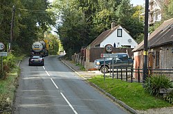
 Entering Cripps Corner on the B2089 | |
| Location | |
| Grid reference: | TQ777212 |
| Location: | 50°57’46"N, 0°31’46"E |
| Data | |
| Post town: | Robertsbridge |
| Postcode: | TN32 |
| Dialling code: | 01580 |
| Local Government | |
| Council: | Rother |
| Parliamentary constituency: |
Bexhill and Battle |
Cripps Corner is a village by Ewhurstin Sussex. It is in the 'High Weald Area of Outstanding Natural Beauty', and on a southern ridge of the valley of the River Rother which flows through Bodiam, two and a half miles to the north of Cripps Corner.[1]
This is one of three settlements in Ewhurst parish, the others being Staplecross and Ewhurst Green to the north. The village borders, and extends over the north-east edge of Sedlescombe parish, and two miles east from the A21 road which runs north to south from Flimwell to Hastings. The village is centred on the convergence of three roads forming an open triangle: the B2165 (from Cripps Corner to Beckley at the north-east; the B2089 from the A21 to Rye at the east; and the B2244 from The Moor to Sedlescombe at the south).
A viaduct here carries the B2089 over the B2244. It was built in 1834 by Stephen Putnam of St Leonards-on-Sea who was responsible for the improvement of the Sussex section of the road between the Medway towns and Hastings. Putnam followed the designs of Thomas Telford who had, a short while beforehand, been responsible for road-over-road bridges in Kent.
About the village
Brede High Woods, an ancient woodland of 647 acres, owned by the Woodland Trust, is a mile to the east, by the B2089 road.[2][3][4]
At the north-west of Cripps Corner and a hundred yards north of the B2089 road, are 75 Second World War concrete 'dragon's teeth' anti-tank blocks of up to six feet high; the remains of one sector of defences that surrounded Cripps Corner. This line of traps stretch through fields from Cripps Corner to Poppinghole Lane, a road which runs north from the adjacent hamlet of Swaile's Green. The traps surrounding Cripps Corner were augmented with pillboxes, and provided a defence in vulnerable sectors not protected by the "heavily-wooded" surroundings of the village. In the summer and autumn of 1940 Cripps Corner was considered an enclosed 'fortress', or 'nodal point' in a line of defence using natural or man-made barriers which extended south-westward from the village, and south-eastward to the sea at the north-east of Hastings. The Archaeology Data Service states that the group of Cripps Corner defences "represents the finest surviving example in the country of the concrete anti-tank perimeter defences".[5]
Outside links
| ("Wikimedia Commons" has material about Cripps Corner) |
- Ewhurst Parish Council
- Big Green Cardigan music festival
References
- ↑ "About Ewhurst" The Parish of Ewhurst (Parish Council). Retrieved 4 February 2019
- ↑ "Brede High Woods", Woodland Trust. Retrieved 4 February 2019
- ↑ Green, Caitlin; "The 10 Best leafy walks", (3. Brede High Woods, Cripps Corner, East Sussex) The Independent, 17 October 2012. Retrieved 4 February 2019
- ↑ Thompson, Nigel; " Top 10 wonderful woods where you'll fall in love with the glory of autumn", (7: Brede High Woods: Cripps Corner, E Sussex), Daily Mirror, 17 October2015. Retrieved 4 February 2019
- ↑ "Defence Area 18, Cripps Corner", Archaeology Data Service, Retrieved 4 February 2019
