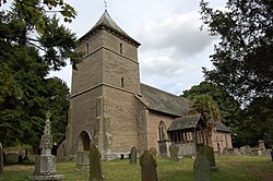
Credenhill
| Credenhill | |
| Herefordshire | |
|---|---|
 St Mary's Church | |
| Location | |
| Grid reference: | SO452437 |
| Location: | 52°5’20"N, 2°48’4"W |
| Data | |
| Local Government | |
| Council: | Herefordshire |
Credenhill is a village in Herefordshire. At the 2011 Census it had a recorded population of 2,271.
Near Credenhill is the site of the former Royal Air Force station RAF Credenhill which was redeveloped by the Army for new headquarters for the 22 Special Air Service Regiment who moved in 1999 and in 2000 the base was designated as Stirling Lines.[1][2]
Parish church
The 12th-century church of St Mary is a Grade I listed building.[3]
History
In around 80 BC, in the Iron Age, a hill fort and earthwork defence system commanding the surrounding area were built.
The Romans founded the town of Magnae at what is now Kenchester. In or about the year 428, Magnae was destroyed by a fire during raids by the Picts and Scots. The remains of the old fort was occupied by the Saxons in 480 AD. The Saxon king Creoda of Mercia occupied the fort in 540 AD, and "Creoda's Hill" gave its name to Credenhill.
During the First World War, land in Credenhill was occupied by an army unit to store ammunition. In 1939 the land was requisitioned for defence and became RAF Hereford.
Surrounding area
There is an Iron Age hill fort half a mile north of Credenhill. Archaeological finds are in Hereford Museum. The defences of this very large hill fort follow the 600 ft contour and enclose nearly 50 acres. They comprise an embankment and ditch with a slight counter-Escarpment|scarp bank. There are traces of a quarry ditch inside the main rampart around most of the circuit. Original in-turned entrances are at the centre of the east side and at the south-east corner, each approached by a hollow way cut deeply into the hillside.
Trial excavation has shown that the internal quarry-ditch is 5–10 ft deep. Its gradual in-filling was found to include various occupation layers associated with rectangular wooden buildings with four corner posts, measuring about 12 x 8 feet, which had been rebuilt several times in the same place. There were also storage pits and other remains of occupation including pottery with stamped and incised patterns typical of the West Midlands Iron Age. Date, c. 400 BC; occupied continuously until about 75 AD. The fort and the surrounding ancient woodland are now part of the Woodland Trust.
Outside links
| ("Wikimedia Commons" has material about Credenhill) |
References
- ↑ Goodwin, Nicola (6 May 2010). "SAS: Troopers tell their stories". BBC. http://news.bbc.co.uk/local/herefordandworcester/low/people_and_places/history/newsid_8638000/8638149.stm. Retrieved 23 June 2017.
- ↑ "RAF Hereford (Credenhill) - RAF Stations - H". M B Barrass. http://www.rafweb.org/Stations/Stations-H.htm#Hereford. Retrieved 23 June 2017.
- ↑ Church of St Mary, Credenhill - British Listed Buildings