Difference between revisions of "Coveney"
(Created page with '{{Infobox town |name=Coveney |county=Cambridgeshire |picture=Coveney Parish Church - geograph.org.uk - 131339.jpg |picture caption=St Peter ad Vincula parish church |os grid ref…') |
|||
| Line 14: | Line 14: | ||
|website= | |website= | ||
}} | }} | ||
| − | '''Coveney''' is a village north of [[ | + | '''Coveney''' is a village in [[Cambridgeshire]], north of the [[county town]], [[Cambridge]] within the [[Great Fen]]. |
The village is on a small 'island' in the fen rising to 43 feet above sea level, 3½ miles west of [[Ely]] as the crow flies (but nearly twice that distance by the main road). The village is on a by-road which leaves the main Ely–Chatteris road at Wentworth crossroads, about 2 miles south. This by-road, which has a branch to the hamlet of Wardy Hill, a mile west of Coveney village, used to be the only metalled road into the parish. Since those days, the drove ways across Ely West Fen, by Frogs Abbey, to Downham Hythe, and from Wardy Hill to Witcham have been made up for wheeled traffic, though only in recent years. | The village is on a small 'island' in the fen rising to 43 feet above sea level, 3½ miles west of [[Ely]] as the crow flies (but nearly twice that distance by the main road). The village is on a by-road which leaves the main Ely–Chatteris road at Wentworth crossroads, about 2 miles south. This by-road, which has a branch to the hamlet of Wardy Hill, a mile west of Coveney village, used to be the only metalled road into the parish. Since those days, the drove ways across Ely West Fen, by Frogs Abbey, to Downham Hythe, and from Wardy Hill to Witcham have been made up for wheeled traffic, though only in recent years. | ||
Latest revision as of 11:34, 10 December 2015
| Coveney | |
| Cambridgeshire | |
|---|---|
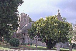
 St Peter ad Vincula parish church | |
| Location | |
| Grid reference: | TL496821 |
| Location: | 52°25’12"N, 0°12’0"E |
| Data | |
| Population: | 424 (2011) |
| Local Government | |
| Council: | East Cambridgeshire |
Coveney is a village in Cambridgeshire, north of the county town, Cambridge within the Great Fen.
The village is on a small 'island' in the fen rising to 43 feet above sea level, 3½ miles west of Ely as the crow flies (but nearly twice that distance by the main road). The village is on a by-road which leaves the main Ely–Chatteris road at Wentworth crossroads, about 2 miles south. This by-road, which has a branch to the hamlet of Wardy Hill, a mile west of Coveney village, used to be the only metalled road into the parish. Since those days, the drove ways across Ely West Fen, by Frogs Abbey, to Downham Hythe, and from Wardy Hill to Witcham have been made up for wheeled traffic, though only in recent years.
Several bronze axes have been found here, shields and a few swords, all dating from the late Bronze Age.[1]
Outside links
| ("Wikimedia Commons" has material about Coveney) |
References
- ↑ David Hall and John Coles (1994). Fenland survey : an essay in landscape and persistence. London: English Heritage. pp. 81–88. ISBN 1-85074-477-7.