Difference between revisions of "Combe Hay"
(Created page with "{{Infobox town |name=Combe Hay |county=Somerset |picture=Combe Hay Church.jpg |picture caption=Combe Hay Church |os grid ref=ST735600 |latitude=51.3389 |longitude=-2.381 |popu...") |
(No difference)
|
Latest revision as of 18:41, 27 March 2020
| Combe Hay | |
| Somerset | |
|---|---|
 Combe Hay Church | |
| Location | |
| Grid reference: | ST735600 |
| Location: | 51°20’20"N, 2°22’52"W |
| Data | |
| Population: | 147 (2011) |
| Post town: | Bath |
| Postcode: | BA2 |
| Local Government | |
| Council: | Bath & NE Somerset |
| Parliamentary constituency: |
North East Somerset |
Combe Hay is a village in Somerset, in the north of the county within the Wellow Hundred.[1]. The parish has a population of 147.
History

Combe Hay was known in the Domesday Book as Cumb, which is Old English for 'valley' (a word originally from the Old Welsh language).
The village includes a church with a 15th-century tower, the Georgian Combe Hay Manor[2] and Georgian rectory.[3]
Combe Hay was the site of a series of locks, dating from 1805 on the Somerset Coal Canal on which research and restoration is proposed. It is the site of one of the only Caisson locks ever built which was near the current Caisson House.[4] Many of the locks and associated workings are listed structures.[5][6] It was also served by the Camerton and Limpley Stoke Railway.
From the 1880s until 1980 mines extracting fuller's earth were to be found in Combe Hay.[7][8] During World War II production expanded to supply foundries and in paint production. Work was scheduled under the Essential Works Order 1941 and new equipment installed.
The site was bombed on the night of 25–26 April 1942 during the Baedeker Blitz raids on Bath, causing damage to some of the machines. The next night local residents sheltered in the mine. By the end of the war production was up to 250 tins a week. By 1949 the site had been electrified, therefore the Garrett steam engine was sold and the chimney demolished. The Fuller's Earth Union was taken over by Laporte plc. In 1978 a new extension was built making granules for cat litter, but in 1979 a major customer making cars in the West Midlands closed and production was wound down until closure in 1980.[9]
The village appears in the Ealing Comedy The Titfield Thunderbolt.
Parish church
The parish church has a 15th-century tower but the body of the church was altered in the late 18th century and restored with the addition of a south aisle and porch in 1874, possibly by the Lord of the manor, George Smart.[10]
Pictures
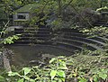
Weir on the Cam Brook at Combe Hay
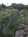
Derelict lock on the Somerset Coal Canal next to Caisson House


Outside links
| ("Wikimedia Commons" has material about Combe Hay) |
References
- ↑ "Somerset Hundreds". GENUKI. http://www.genuki.org.uk/big/eng/SOM/Miscellaneous/. Retrieved 22 October 2011.
- ↑ National Heritage List 1115363: Combe Hay Manor
- ↑ National Heritage List 1135965: The Old Rectory
- ↑ National Heritage List 1115371: Caisson House
- ↑ National Heritage List 1115372: Flight of 10 locks
- ↑ National Heritage List 1320442: Remains of the Basin at the bottom of the Inclined Plane
- ↑ A. B. Hawkins, M. S. Lawrence and K. D. Privett (September 1986). "Clay Mineralogy and Plasticity of the Fuller's Earth Formation Bath, UK". Clay Minerals (The Mineralogical Society) 21 (3): 293–310. doi:10.1180/claymin.1986.021.3.04. http://claymin.geoscienceworld.org/cgi/content/abstract/21/3/293. Retrieved 30 September 2010.
- ↑ Macmillen, Neil (2009). A history of the Fuller's Earth mining industry around Bath. Lydney: Lightmoor Press. pp. 54–57. ISBN 978-1-899889-32-7.
- ↑ Macmillen, Neil (2009). A history of the Fuller's Earth mining industry around Bath. Lydney: Lightmoor Press. pp. 101–116. ISBN 978-1-899889-32-7.
- ↑ National Heritage List 1115357: Combe Hay parish church