Combe Down
| Combe Down | |
| Somerset | |
|---|---|
 Holy Trinity Church | |
| Location | |
| Grid reference: | ST763625 |
| Location: | 51°21’40"N, 2°20’31"W |
| Data | |
| Population: | 5,419 (2011) |
| Post town: | Bath |
| Postcode: | BA2 |
| Dialling code: | 01225 |
| Local Government | |
| Council: | Bath & NE Somerset |
| Parliamentary constituency: |
Bath |
Combe Down is a village suburb of Bath in Somerset, consisting predominantly of 18th and 19th century Bath stone-built villas, terraces and workers' cottages; the Foxhill estate built after the Second World War consists of former and present council housing; and a range of Georgian, Victorian and 20th century properties along both sides of North Road and Bradford Road.
Combe Down sits on a ridge above Bath, approximately a mile and a half to the south of the city centre. The village is adjoined to the north by large areas of natural woodland (Fairy Wood, Long Wood, Klondyke Copse and Rainbow Wood) with public footpaths offering views overlooking the city. Parts of these woods are owned and managed by Bath & Northeast Somerset Council, but the majority are owned and managed by the National Trust and incorporate the Bath Skyline trail. To the south of the village are views of the Midford Valley.
Contents
About the village
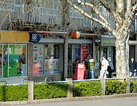
Combe Down has many local amenities including schools, churches, shops, local societies and pubs.
The local state primary school is Combe Down CEVC (Church of England Voluntary Controlled) Primary School, housed partly in a log cabin imported from Finland.[1]
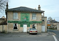
The village pubs are the King William IV, the Hadley Arms and the Forester & Flower (formerly The Foresters).
Churches
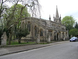
The parish church is the Church of the Holy Trinity[2]) in the village. The Church Rooms in the centre of the village are available for hire by local groups.
There is anon-conformist church, the Union Chapel.
A Roman Catholic church (St Peter and St Paul) stands on the edge of the village, adjacent to the Foxhill estate.
History
It is believed that a Roman villa was situated on the southern slopes of the village somewhere below Belmont Road,[3] the site of which was discovered in the 1850s.[4] An inscription on a stone recovered from the area reads "PRO SALVTE IMP CES M AVR ANTONINI PII FELICIS INVICTI AVG NAEVIVS AVG LIB ADIVT PROC PRINCIPIA RVINA OPRESS A SOLO RESTITVIT". This can be translated as: "For the health of Imperator Caesar Marcus Aurelius Antoninus Pius Felix Invictus Augustus, Naevius the imperial freedman, helped to restore from its foundations the procurator's headquarters which had broken down in ruins." It is thought to date from AD 212–222.[5] Many finds from the site were taken to the Somerset County Museum at Taunton.
John Leland, the 16th century antiquarian and traveller, noted some stone mining activity in Combe Down as he passed by.
By 1700, small open stone quarries were operating on Combe Down. Most of the land and the quarries were purchased by Ralph Allen in 1726 but there was as yet little habitation.[6]
In 1791 John Collinson describes Combe Down as still undeveloped:
"On the summit of Combedown a mile northward from the church [mc], among many immense quarries of fine free stone, are large groves of firs, planted by the late Ralph Allen, esq; for the laudable purpose of ornamenting this (at that time rough and barren) hill. Among these groves is a neat range of buildings belonging to this parish. It consists of eleven houses [De Montalt Place], built of wrought stone, raised on the spot ; each of which has a small garden in front. These were originally built for the workmen employed in the quarries, but are now chiefly let to invalids from Bath who retire hither for the sake of a very fine air-, (probably rendered more salubrious by the Plantation of firs) from which many have received essential benefit. The surrounding beautiful and extensive prospects ; the wild, but pleasing irregularities of the surface and scenery, diversified with immense quarries, fine open cultivated fields, and extensive plantations of firs...".[7]
From their 1924 history of Combe Down, D. Lee Pitcairn and Rev. Alfred Richardson state that:
"The houses in Isabella Place were built about 1800, and in 1805 when the De Montalt Mills were founded cottages were erected in Quarry Bottom and Davidge's Bottom to take the place of wooden booths which labourers and workmen had hitherto occupied for the day and in which they had sometimes slept during the week. From this time onwards the place began to develop little by little... In 1829 when the Combe Down quarries were disposed of by Mrs. Cruickshank, building further increased...".[8]
The population increased from 1,600 in 1841 to 2,372 in 1901[9] and was 5,419 in 2011.[10]
Stone mines and quarries
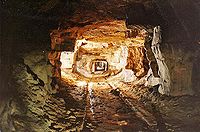
Combe Down sits above an area of redundant 18th and 19th century stone quarries, many of which were owned and developed by Ralph Allen in the 1720s. The quarries were fully infilled and stabilised during a central government-funded project which took place between 2005 and 2010. Over 40 quarry sites have been identified on Combe Down.[11] Only one working quarry (Upper Lawn Quarry) remains on the edge of the village, located off Shaft Road, which supplies high quality Bath stone to the city and across Britain.[12]
John Leland, the 16th century antiquarian and traveller, wrote in the 1500s that he approached Bath from Midford "...And about a Mile farther I can to a Village and passd over a Ston Bridge where ranne a litle broke there & they caullid Midford-Water..2 good Miles al by Mountayne and Quarre and litle wood in syte..."[13] which could be a reference to quarrying around Horsecombe Vale, between Midford and Combe Down.
The mines at Combe Down were Oolitic (oolite) limestone mines. Stone was extracted by the "room and pillar" method, by which chambers were mined out, leaving pillars of stone to support the roof. The Bath stone used for many of the buildings in Bath – as well as for other important buildings around the United Kingdom including Buckingham Palace – was mined from beneath and around Combe Down. Many of these workings were once owned by the eighteenth century entrepreneur Ralph Allen (1694–1764). [14] The mines were closed in the 19th century but building work continued above ground, with some roads and houses eventually resting on only a thin crust – in places between only one and two metres deep – above large underground cavities with inadequate support.[14]
Combe Down railway tunnel
Combe Down Tunnel was opened in 1874 and emerges below the southern slopes of the village. It was once Britain's longest railway tunnel (1,829 yards) without intermediate ventilation.[15] The tunnel now forms part of the £1.8 million Two Tunnels Greenway walking and cycling path which opened on 6 April 2013. At over a mile long, the Combe Down tunnel is the longest cycling tunnel in Britain and features an interactive light and sound installation as well as mobile phone coverage.[16] Its custodian is Wessex Water.
Jewish burial ground
The Jewish burial ground is a site of historic value on Bradford Road and is one of only fifteen in the country to survive from the Georgian period. It dates from 1812, and the last recorded burial was in 1946. The Ohel which dates from around 1836 is of particular interest as there are few such examples still standing.
Sport and leisure
Combe Down has two flourishing rugby union clubs and a cricket club and an active Cub and Scout Group (10th Bath) with its own Scouts' Hut. There are several societies, including an active local history group (the Combe Down Heritage Society), a branch of the Women's Institute and two art groups.
About the village
There is a private hospital, BMI Bath Clinic, on Claverton Down Road, based at Longwood House the former home of the Mallet family of Mallet Antiques.
Margaret Mary Mallett (1882 – 1959), who lived at Longwood House, and her daughters, Margaret Elizabeth Mallett (1905 – 1991) and Barbara Penelope Mallett Lock (1896 – 1978) donated 347 acres of land on Combe Down and Claverton Down including Rainbow Wood farm, Klondyke Copse, Fairy Wood and Bushey Norwood to the National Trust.[17] Opposite the hospital is a 4-star hotel and health club, Combe Grove Manor, with 69 acres of gardens and woodland.
A public open space (Firs Field) incorporates the village war memorial and a play area with children's play equipment. Three parcels of land make up the Firs Field open space, two of which are under the control of the local Council. The deeds state that the Firs Field is intended for the recreation of the residents of Combe Down in perpetuity. Firs Field was restored to meadowland status following the successful completion of the stone mine stabilisation works in 2010. A residents' group (The Friends of Firs Field) exists to ensure the appropriate representation of local residents' interests with regard to the management of the field. In 2015 Firs Field was granted "commemorative" status and designated an official Fields in Trust "Centenary Field".
Outside links
| ("Wikimedia Commons" has material about Combe Down) |
- Combe Down Heritage Society
- Combe Down CEVC Primary School
- Combe Down Nursery
- Combe Down RFC Rugby Club
- Combe Down Stone:
- Combe Down Surgery
- Friends of Bath Jewish Burial Ground
- Holy Trinity Church
- Monkton Prep School, Pre-Prep and Nursery
- Oldfield Old Boys RFC Rugby Club
- Union Chapel
- Combe Down Art Group
References
- ↑ "History of the School". Combe Down School. Archived from the original on 27 May 2015. https://web.archive.org/web/20150527184443/http://www.combedown.com/our-school/history. Retrieved 26 May 2015.
- ↑ National Heritage List 1394011: Church of The Holy Trinity
- ↑ Harry Mengden Scarth (1864). Aquae Solis: Or Notices of Roman Bath. Simpkin, Marshall, & Company. pp. 11–. https://archive.org/details/bub_gb_68dBLpQms4oC.
- ↑ Vanderbilt, S.. "Places: 544572531 (Combe Down)". Pleiades. https://pleiades.stoa.org/places/544572531. Retrieved 10 November 2018.
- ↑ "Roman-Britain.org". Romano-British Villa, Combe Down, Monkton Combe, Avon. Archived from the original on 20 February 2015. https://web.archive.org/web/20150220011756/http://www.roman-britain.org/places/combe_down.htm. Retrieved 26 May 2015.
- ↑ "Combe Down Heritage Society". History. Archived from the original on 15 April 2015. https://web.archive.org/web/20150415031646/http://www.combedownheritage.org.uk/. Retrieved 30 May 2015.
- ↑ John Collinson; Edmund Rack: 'The History and Antiquities of the County of Somerset: Collected from Authentick Records, and an Actual Survey Made by the Late Mr. Edmund Rack ... Adorned with a Map of the County, and Engravings of Roman Or Other Reliques, Town-seals, Baths, Churches, and Gentlemen's Seats' (1791) pages 151–
- ↑ David Lee Pitcairn; Alfred Richardson (1924). An Historical Guide to Monkton Combe, Combe Down, and Claverton. F.Goodall. Archived from the original on 9 December 2017. https://web.archive.org/web/20171209110124/https://books.google.com/books?id=AMUXMwEACAAJ.
- ↑ "combedown.org". Properties & Population on Combe Down 1841 to 1901 from census reports. Archived from the original on 22 May 2015. https://web.archive.org/web/20150522035921/http://www.combedown.org/on-combe-down/on-combe-down-1850-1900/. Retrieved 30 May 2015.
- ↑ "Census 2011". Combe Down Ward. Archived from the original on 4 March 2016. https://web.archive.org/web/20160304112219/http://www.bathnes.gov.uk/sites/default/files/census_2011_-_ward_profile_-_combe_down.pdf. Retrieved 30 May 2015.
- ↑ "Combe Down Quarries". Prior to Now. https://www.combedown.org/combe-down-development-timeline/combe-down-quarries/. Retrieved 9 December 2017.
- ↑ "Upper Lawn Quarry". BRE. Archived from the original on 28 September 2011. https://web.archive.org/web/20110928115940/http://projects.bre.co.uk/ConDiv/stonelist/combedown.html. Retrieved 25 September 2011.
- ↑ John Leland (1768). The itinerary of John Leland, publ. by T. Hearne, To which is prefix'd mr. Leland's New-year's gift. pp. 1–. Archived from the original on 9 December 2017. https://web.archive.org/web/20171209110124/https://books.google.com/books?id=0U0VAAAAQAAJ&pg=RA1-PA61.
- ↑ 14.0 14.1 "Combe Down Stone Mines". Combe Down Stone Mines. Archived from the original on 11 October 2015. https://web.archive.org/web/20151011084116/http://combedown.aeriantest.co.uk/. Retrieved 30 May 2015.
- ↑ Yorke, Stan (2007). Lost railways of Somerset. Newbury: Countryside Books. pp. 48–60. ISBN 978-1-84674-057-2
- ↑ "Sustrans". Bath Two Tunnels Circuit. Archived from the original on 16 January 2014. https://web.archive.org/web/20140116212229/http://www.sustrans.org.uk/ncn/map/route/bath-two-tunnels. Retrieved 26 May 2015.
- ↑ "combedown.org". National Trust. Archived from the original on 22 May 2015. https://web.archive.org/web/20150522035919/http://www.combedown.org/on-combe-down/on-combe-down-since-1950/. Retrieved 30 May 2015.


