Coleraine
| Coleraine | |
| County Londonderry | |
|---|---|
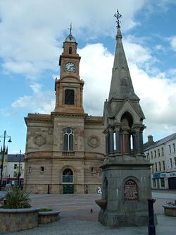
 Coleraine town hall | |
| Location | |
| Grid reference: | C844328 |
| Location: | 55°7’59"N, 6°39’40"W |
| Data | |
| Population: | 24,042 (2001) |
| Post town: | Coleraine |
| Postcode: | BT51, BT52 |
| Dialling code: | 028 |
| Local Government | |
| Council: | Coleraine BC |
| Parliamentary constituency: |
East Londonderry |
Coleraine is a large town in County Londonderry near to the mouth of the River Bann. It is 55 miles northwest of Belfast and 30 miles east of Londonderry.
The town's name derives from the Gaelic Cúil Raithin, meaning "nook of the ferns"[1])
The town
Coleraine stands at the lowest bridgeable point of the River Bann, where the river is a quarter of a mile wide. The town has a marina on the river estuary. The town square is called 'The Diamond' and is the location of the Town Hall. St Patrick's (Church of Ireland) is nearby.
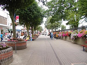
Coleraine is a busy, prosperous town, with average income well above the above the regional average and with the highest property prices in Northern Ireland.[2] It is the major commercial centre in County Londonderry. It has an attractive town centre, a marina and the Riverside Theatre.
The University of Ulster campus was built in the 1960s but is one of the better pieces of architecture from that era and has brought a high quality theatrical space to the town in the form of the Riverside Theatre, where the quality of production often belies the small size of the town.
Outside Coleraine are championship golf courses, scenic countryside and attractions.
History
The Mesolithic site at Mount Sandel dates from approximately 5935 BC.[3] The town itself dates from not so early a period, and owes its present from to the Plantation of Ulster.
Coleraine was one of the two urban communities developed by the London Companies in County Londonderry during the Plantation of Ulster at the start of the 17th century. The slightly skewed street pattern of Coleraine's town centre is legacy of that early exercise in town planning, along with traces of the lines of the ramparts that provided the Plantation town with its defences.
In 1637 the Surveyor General of Customs issued a report compiled from accounts of customs due from each port and their "subsidiary creeks". Of the Ulster ports on the list, Carrickfergus was first, followed by Bangor, Donaghadee, and Strangford. Carlingford and Coleraine each had £244 customs due and had equal ranking.[4]
With some industrialisation, the expansion of the river port, and the development of the railway, the town expanded significantly throughout the 19th century and into the early part of the 20th century. Coleraine steadily expanded after the Second World War. The population doubled due to major industrial development on extensive suburban sites, the decision to site the New University of Ulster (now known as the University of Ulster) in the town, the expansion of commerce and the development of sporting and recreational facilities. There has been a steady expansion of the urban area from the mid 20th century compact town of less than 1¼ square miles to the present much more dispersed town of about 7 square miles.
Outside the town
Coleraine is the main town of the world famous Causeway Coast, which attracts over two million visitors per year, spending in excess of £37 million .[5] The world famous Giant's Causeway is a twenty–five minute bus ride away. The distillery village of Bushmills is well-served by buses from the town and there is a narrow-gauge steam train running in the summer from Bushmills to the Giant's Causeway.
Also north of Coleraine is the spectacularly scenic coastal town of Portstewart, with fine sandy beach and coastal walks.
Northwest of Coleraine lies the small village of Castlerock, with a beach which is essentially a continuation of the beach at Portstewart, separated by the River Bann. Also nearby is the huge beach at Benone Strand and Mussenden Temple, built by Frederick Augustus Hervey, an 18th-century Anglican bishop atop a precipitate cliff and overlooking County Donegal in one direction and Argyll in another. Downhill Forest, managed by the National Trust was part of the Bishop's Palace, and although the Palace itself is now a ruin the gardens are a wonderful place full of strange hidden lakes and gloriously tended flower gardens.
Flanking the east side of the town is the Mountsandel Forest, which contains the impressive Mount Sandel Fort, an ancient site which has been claimed as the oldest site of human settlement in Ireland. Here were uncovered wooden houses dating from about 7000 BC.[6][7] Access to the fort can be gained by way of Mountsandel Forest. Another fort is found about 2 miles south from Mount Sandel.
References
- ↑ Flanaghan, Deirdre & Laurence; Irish Place Names, page 194. Gill & Macmillan, 2002. ISBN 0-7171-3396-6
- ↑ University of Ulster Quarterly House Price Index report produced in partnership with Bank of Ireland and the Northern Ireland Housing Executive - March 2006
- ↑ The Statesman's Yearbook 2007, Macmillan Publishing, page 678, edited by Barry Turner, ISBN 10-1403992762/ISBN 13-97814039092765
- ↑ O'Sullivan, Aidan & Breen, Colin (2007). Maritime Ireland. An Archaeology of Coastal Communities. Stroud: Tempus. p. 212. ISBN 978-0-7524-2509-2.
- ↑ "Investing in Coleraine". Capital of the Causeway Coast. http://www.coleraine.co.uk/htmlsite/investing.asp?step=2&id=4&pstring=4. Retrieved 2007-09-14.
- ↑ "Mount Sandel, Ireland". about.com. http://archaeology.about.com/od/mesolithicarchaic/a/mount_sandel.htm. Retrieved 2007-09-14.
- ↑ "Prehistory". Causeway Coast and Glens Heritage Trust. http://www.ccght.org/environmental_management/cultural_heritage/prehistory/. Retrieved 2007-09-14.
