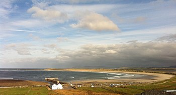
Cloughaneely
Cloughaneely is a district in the west of County Donegal. This is a mainly coastal area with a population of over 4,000 centred on the towns of Falcarragh and Gortahork.
It is a Gaeltacht area, meaning the Irish language is spoken prominently. Cloughaneely, The Rosses and Gweedore, known locally as "the three parishes", have 16,000 Irish speakers, and together form a social and cultural region different from the rest of the county, with Gweedore serving as the main centre for industry.
Places of interest include Cnoc na Naomh, considered to be a mountain with religious significance.[1]
Name
The name 'Cloich Cheann Fhaola, also written Cloich Chionnaola, means "the Stone of Feeley's Head": this comes from a story which tells of the killing of McFeeley. The story says that Balor of the Evil Eye beheaded him on a rock because he had stolen the Cow of Plenty that Balor had on the island of Toraigh (Tory Island) from Balor's grasp and brought it back to the mainland.
Townlands in Cloughaneely
- Location map: 55°7’30"N, 8°7’30"W
- OS map: B847228
- Ballyness (Baile an Easa)
- Ballingat (Baile an Gheata)
- Ballyconnell (Baile Chonaill)
- Ballytemple (Baile an Teampaill)
- Caoldroim Íochtarach (Lower Keeldrum)
- Caoldrum lar (Middle Keeldrum)
- Caoldrum Thuas ( Upper Keeldrum)
- Derryconnor (Doire Chonaire)
- Falcarragh (An Fál Carrach)
- Gortahork (Gort an Choirce)
- Killult (Cill Ulta)
- Magheroarty (Machaire Rabhartaigh)
- Meenlaragh (Mín Lárach)
- An Sruthán Riach
Islands
- Inishbofin (Inis Bó Finne)
- Tory Island (Oileán Thoraigh)
Outside links
References
- ↑ "Christine's Faery List: Coll". www.tartanplace.com. http://www.tartanplace.com/faery/gods/coll.html.


