Clophill
| Clophill | |
| Bedfordshire | |
|---|---|
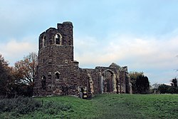
 St Mary's Old Church | |
| Location | |
| Grid reference: | TL086380 |
| Location: | 52°1’38"N, 0°25’29"W |
| Data | |
| Population: | 1,750 (2009 est.) |
| Post town: | Bedford |
| Postcode: | MK45 |
| Dialling code: | 01525 |
| Local Government | |
| Council: | Central Bedfordshire |
| Parliamentary constituency: |
Mid Bedfordshire |
Clophill is a small village in the Flit river valley in Bedfordshire. The village formerly belonged to a group of two or three hamlets – Beadlow, Cainhoe and possibly Moddry. It is recorded in the Domesday Book of 1086 as Clopelle; meaning 'Tree-stump Hill'.
The Domesday Book entry reads: Clopelle: Nigel d'Aubigny.
In the 1851 census, out of a total male population in Clophill of 560, there were some 238 agricultural labourers; some years later in 1871 census, out of a total female population in Clophill of 655.
Churches
- Church of England:
- St Mary's old church (abandoned)
- St Mary the Virgin
- Clophill Methodist Church
The old St Marys Church was built around 1350, and replaced by a new church in the 1840s. The old church gradually fell into ruin, though there are plans to give it a new use, as a bothy on the Greensand Ridge walk.[1]
The new St Mary's church is in the High Street in the village. It was built 1848-1849. It incorporates mediæval beams from the old church. The East Window is from the modern era.
Public houses
- The Flying Horse
- The Green Man - La Stalla (Restaurant)
- The Stone Jug
Outside links
| ("Wikimedia Commons" has material about Clophill) |
- Clophill pages at the Bedfordshire and Luton Archives and Records Service
- [http://www.stmaryschurchclophill.org Clophill Village Church
- Clophill History - 'A History of the County of Bedford Vol 2'
