Difference between revisions of "Claxby Pluckacre"
(Created page with "{{Infobox town |name=Claxby Pluckacre |county=Lincolnshire |picture=Hall Farm, Claxby Pluckacre - geograph.org.uk - 481377.jpg |picture caption=Hall Farm, Claxby Pluckacre |os...") |
(No difference)
|
Latest revision as of 20:39, 29 September 2020
| Claxby Pluckacre | |
| Lincolnshire | |
|---|---|
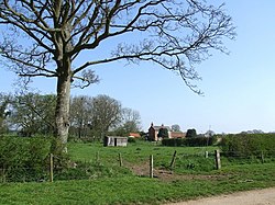
 Hall Farm, Claxby Pluckacre | |
| Location | |
| Grid reference: | TF304644 |
| Location: | 53°9’40"N, 0°2’59"W |
| Data | |
| Post town: | Boston |
| Postcode: | PE22 |
| Local Government | |
| Council: | East Lindsey |
| Parliamentary constituency: |
Louth and Horncastle |
Claxby Pluckacre is a hamlet in Lindsey, the northern part of Lincolnshire, about five miles south-east of the nearest town, Horncastle. It is associated with the parish of Wood Enderby.
Whilst Claxby Pluckacre is listed in the 1086 Domesday Book, today it is considered a deserted mediæval village with slight earthworks visible between Hall Farm and The Grange.[1][2]
Claxby Pluckacre once had a church, dedicated to St Andrew, which fell down in 1748 and was never rebuilt. The last priest was instituted 1660-62.[3] Whilst nothing remains it can be seen as earthworks.[1]
Events
Each year, in July, there is an annual pilgrimage to the site of St Andrew's Church. The Mareham le Fen Victory Silver Band provides the music for a service which commemorates the over 250 villages and hamlets lost in Lincolnshire over the past four centuries.
Outside links
| ("Wikimedia Commons" has material about Claxby Pluckacre) |
References
- ↑ 1.0 1.1 National Monuments Record: No. 354185 – Claxby Pluckacre deserted mediæval village
- ↑ Shrunken village of Claxby Pluckacre: Lincs to the Past
- ↑ Site of St Andrews Church: Lincs to the Past