Cherry Burton
| Cherry Burton | |
| Yorkshire East Riding | |
|---|---|
.jpg) St Michael and All Angels Church | |
| Location | |
| Grid reference: | SE989420 |
| Location: | 53°51’54"N, 0°29’48"W |
| Data | |
| Population: | 1,392 (2011) |
| Post town: | Beverley |
| Postcode: | HU17 |
| Dialling code: | 01964 |
| Local Government | |
| Council: | East Riding of Yorkshire |
| Parliamentary constituency: |
Beverley and Holderness |
Cherry Burton is a village in the East Riding of Yorkshire, sitting three miles north-west of the market town of Beverley,[1] nine miles east of Market Weighton and eleven miles south-west of Driffield.[2] The village stands on the eastern edge of the Yorkshire Wolds, to the west of the B1248 road.
Contents
Name
The name of the village is a combination of Old and Middle English: its original name appears to have been Burhtun, indicating a fortified place, or 'Burtun' meaning a farmstead, and in the Middle Ages Chiri ('cherry') was added.[3] Because of its location, a mile north of Bishop Burton, the village was sometimes known as 'North Burton' (or occasionally as 'Sheriff Burton').[4][5]
Churches
A Wesleyan Methodist chapel was built in 1824, followed by a Primitive Wesleyan Methodist chapel in 1851; both have ceased being used for worship with the Wesleyan chapel now being the village hall.
The Church of England parish church, St Michael, was built in the village in 1852. It is a Grade II listed building.[6] St Michael's was built on the site of a previous undated church.[7]
History
The village is mentioned in the Domesday Book as Burtone, and as belonging to the Archbishop of York.[8]
Until rapid house-building in the 1960s and 1970s, the village mostly consisted of one long main street as laid down in the 18th and 19th centuries with farmhouses.[9]
Cherry Burton railway station on the York to Beverley Line served the village between 1865 and 1959,[10] with the station remaining open for another five years for the inward and outward transportation of agricultural produce. The line closed completely in 1965.[11]
In 2011–2012, a flood alleviation scheme was implemented. Like many other places in the East Riding, Cherry Burton was subject to severe flooding in the 2007 floods.[12]
About the village
The village has a local shop with a post office. The village hall holds live musical events and hosts an annual local pantomime. The village pub, The Bay Horse, holds events each week. The village has a Church of England primary school.
Sport and leisure
Sports in the village include cricket, football, tennis, and rounders. Clubs for cricket and football have junior sections. Just outside of the village is a golf course and leisure park currently under development.
In 2018, a new footpath from the village to the old railway line opened, which allowed the inhabitants of Cherry Burton to access the Hudson Way, a foot and cycle path built on the formation of the old railway line.[13] Previous to this, to access the path, villagers needed to negotiate the main road out of the village which had no footpaths and perilously fast traffic.
Pictures
| ("Wikimedia Commons" has material about Cherry Burton) |
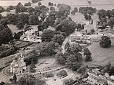
Aerial Photo Cherry Burton (1960)
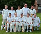
Cherry Burton Cricket Club team photo, 15 May 2008
- Cherry burton brexit street party 2016.jpg
Cherry Burton Brexit Party, June 2016
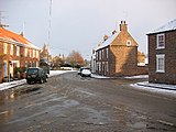
A winter day in Cherry Burton
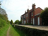
Cherry Burton railway station
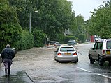
Cherry Burton in the 2007 floods


Outside links
References
- ↑ Information on Cherry Burton from GENUKI
- ↑ Langdale, Thomas (1809). A topographical dictionary of Yorkshire : containing the names of all the towns, villages, hamlets, gentlemen's seats, &c. in the county of York. Northallerton: J Langdale. p. 98. OCLC 427481667. https://archive.org/details/atopographicald00langgoog.
- ↑ Ekwall, Eilert, The Concise Oxford Dictionary of English Place-Names. Oxford, Oxford University Press, 4th edition, 1960. ISBN 0198691033
- ↑ Oliver, George (1829). he history and antiquities of the town and minster of Beverley, in the county of York, from the most early period. Beverley: Turner. p. 496. OCLC 3552084.
- ↑ Peach, Howard (2001). Curious tales of old East Yorkshire. Wilmslow: Sigma Leisure. p. 172. ISBN 1-85058-749-3.
- ↑ National Heritage List 1310173: Church of St Michael (Grade II listing)
- ↑ Nikolaus Pevsner: The Buildings of England: Yorkshire: York & East Riding, 1972; 1995 Penguin Books ISBN 978-0-300-09593-7page 383
- ↑ Burton Cherry Burton in the Domesday Book
- ↑ Nikolaus Pevsner: The Buildings of England: Yorkshire: York & East Riding, 1972; 1995 Penguin Books ISBN 978-0-300-09593-7page 384
- ↑ Butt, R. V. J. (1995). The Directory of Railway Stations: details every public and private passenger station, halt, platform and stopping place, past and present (1st ed.). Sparkford: Patrick Stephens Ltd. ISBN 978-1-85260-508-7. OCLC 60251199.
- ↑ "Disused Stations: Cherry Burton Station". http://disused-stations.org.uk/c/cherry_burton/index.shtml. Retrieved 13 January 2020.
- ↑ "Work starts on scheme to prevent flooding" (in en). The Yorkshire Post. 6 December 2011. https://www.yorkshirepost.co.uk/news/latest-news/work-starts-on-scheme-to-prevent-flooding-1-4033767. Retrieved 13 January 2020.
- ↑ "TROD Path to Etton Bridge". Cherry Burton Parish Council. http://www.cherryburtonparishcouncil.org.uk/trod-path-to-etton-bridge.aspx. Retrieved 13 January 2020.
- Gazetteer — A–Z of Towns Villages and Hamlets. East Riding of Yorkshire Council. 2006. p. 4.