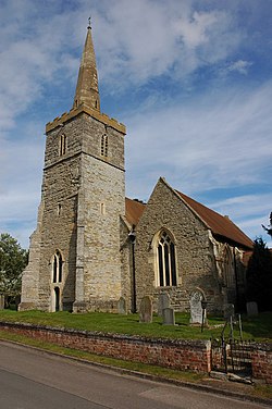
Chaceley
| Chaceley | |
| Worcestershire | |
|---|---|
 St John the Baptist's | |
| Location | |
| Location: | 51°58’23"N, 2°13’16"W |
| Data | |
| Post town: | Gloucester |
| Postcode: | GL19 |
| Local Government | |
| Council: | Tewkesbury |
Chaceley is a village and parish in the southern extremity of Worcestershire. It is situated on the right bank of the River Severn opposite Deerhurst in Gloucestershire. The south-eastern part of the parish, in the Severn Valley, is low and liable to floods but the land rises gradually from the river and at Roundhill, near Hillend, reaches a height of 150 ft above the ordnance datum.
The church stands near Chaceley Court, to the north of which was an ancient tithe barn. West of the village is Hillend, and about half a mile south-west of the church is Newhall, a large 18th-century brick building, with a moat a little to the south of it. An interesting old timbered house standing below Roundhill, now known as Chaceley Hall, was formerly called Chaceley Hole, and has been a Grade II* listed building since 1955. To the north-east of the village is New House, a good specimen of black and white work, at one time the residence of the Buckle family. Newhall Brook flows from Poolhay in Eldersfield past Newhall, and empties itself into the Severn at Chaceley Stock Brickworks, opposite Deerhurst. These brickworks have been long disused. Near Eldersfield, on the western boundary of Chaceley, is Corse Lawn, where a skirmish took place in 1644.