Difference between revisions of "Castleton, Dorset"
From Wikishire
(Created page with "{{distinguish|Castletown, Dorset}} {{Infobox town |name=Castleton |county=Dorset |picture=Sherborne Castle and Lake - geograph.org.uk - 93207.jpg |picture caption=Sherborne Ca...") |
(No difference)
|
Latest revision as of 20:05, 20 May 2020
- Not to be confused with Castletown, Dorset
| Castleton | |
| Dorset | |
|---|---|
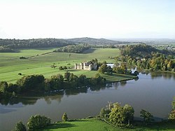
 Sherborne Castle and lake | |
| Location | |
| Grid reference: | ST648168 |
| Location: | 50°57’0"N, 2°28’59"W |
| Data | |
| Population: | 155 (2011) |
| Post town: | Sherborne |
| Postcode: | DT9 |
| Local Government | |
| Council: | Dorset |
| Parliamentary constituency: |
West Dorset |
Castleton is a village in Dorset, just east of Sherborne. The wider parish, which almost encircles the town, contains both Sherborne Castle and Sherborne Old Castle. In the 2011 census the parish had a recorded population of 155.
Roman remains have been found at two sites in the parish: at Pinford Lane, in the east, and near Sandford Lane, in the north. The Pinford Lane site revealed the remains of buildings, an oven or kiln, coins, pottery, brooches and beads. The Sandford Lane site revealed more remains of buildings, coins and one brooch.[1]
Most of the houses in the parish, but not the church, were pulled down when the railway was built through the town.[2]
Outside links
| ("Wikimedia Commons" has material about Castleton, Dorset) |
References
- ↑ Castleton: An Inventory of the Historical Monuments in Dorset, Volume 1, pages 63-70
- ↑ Online Parish Clerk - Sherborne, accessed 1 December 2011