Difference between revisions of "Carrauntoohil"
m |
(might be useful...) |
||
| Line 9: | Line 9: | ||
|os grid ref=V803844 | |os grid ref=V803844 | ||
}} | }} | ||
| − | '''Carrauntoohil''' or '''Carrantuohill''' in [[County Kerry]] is the highest mountain in [[Ireland]], and consequently the [[county top]] of County Kerry. It is the central peak of Ireland's grandest mountain range, [[MacGillycuddy's Reeks]] and rises to 3,406 feet above sea level: one of nine tops in the Reeks to exceed 3,000 feet. The summit of Carrauntoohil is topped by a large metal cross a further 16 feet tall. | + | '''Carrauntoohil''' or '''Carrantuohill''' (/ˌkærənˈtuːl/) in [[County Kerry]] is the highest mountain in [[Ireland]], and consequently the [[county top]] of County Kerry. It is the central peak of Ireland's grandest mountain range, [[MacGillycuddy's Reeks]] and rises to 3,406 feet above sea level: one of nine tops in the Reeks to exceed 3,000 feet. The summit of Carrauntoohil is topped by a large metal cross a further 16 feet tall. |
==Name of the mountain== | ==Name of the mountain== | ||
Revision as of 19:26, 8 August 2015
| Carrauntoohil | |||
| County Kerry | |||
|---|---|---|---|
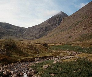
 Carrauntoohil (middle), south along the Hag's Glen | |||
| Range: | MacGillycuddy's Reeks | ||
| Summit: | 3,406 feet V803844 | ||
Carrauntoohil or Carrantuohill (/ˌkærənˈtuːl/) in County Kerry is the highest mountain in Ireland, and consequently the county top of County Kerry. It is the central peak of Ireland's grandest mountain range, MacGillycuddy's Reeks and rises to 3,406 feet above sea level: one of nine tops in the Reeks to exceed 3,000 feet. The summit of Carrauntoohil is topped by a large metal cross a further 16 feet tall.
Name of the mountain
The mountain's name is from the Irish language in which it is called Corrán Tuathail, and means "Tuathal's sickle" or "Tuathal's serrated mountain". However there can be no certainty: it is not mentioned in any surviving early Irish texts.
PW Joyce proposed the "sickle" meaning as suggested by the view from the Hag's Glen of the long convex slope.[1] On the other hand, the mountains has distinct serrated ridges running high up its north face giving it a most distinctive face and perhaps giving its name.
Isaac Weald's account (1812) names the mountain Gheraun-tuel, which suggests "Tuathal's Fang'" (géarán)
Ascent
The mountain is most often climbed from the north-east, along the Hag's Glen and up the steep Devil's Ladder to the col between Carrauntoohil and Knocknapeasta, and then northwest to the summit. The route has become more dangerous as wear from the passing of many feet has worn the stones loose.[2]
The top can be achieved without climbing equipment, with care given to the shifting ground, though the height of the mountain puts it off casual walkers.
Another route takes in the next highest (""1,000 m") summits of Beenkeragh and Caher in a horseshoe, starting from the west. The traverse from highest point to the second highest involves a light scramble.
Outside links
| ("Wikimedia Commons" has material about Carrauntoohil) |
References
- ↑ Joyce, P W in Irish Names of Places, vol I, p 6
- ↑ "Devil's Ladder Route". Kerry mountain rescue. http://www.kerrymountainrescue.ie/routes/devils_ladder.html. Retrieved 2007-01-10.
- Carrauntoohil - Mountain Views |accessdate=2006-11-03}}</ref>