Carlton, Suffolk
| Carlton | |
| Suffolk | |
|---|---|
 St Peter's Church, Carlton | |
| Location | |
| Grid reference: | TM387642 |
| Location: | 52°13’30"N, 1°29’38"E |
| Data | |
| Local Government | |
| Council: | East Suffolk |
Carlton is a village in Suffolk, sitting a mile north of Saxmundham in the east of the county. The village is bordered by Kelsale in the north, the B1121 in the east and the A12 to the west. In 1881 the civil parish had a population of 94.
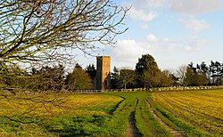
The parish church, St Peter, has a brick tower set amongst arable land in the grounds of Carlton Park.[1]
By this village are all the larger businesses based at the Carlton Park Industrial Estate. Adjoining this is the Carlton Park Sports ground which is owned by Saxmundham Sports Club, also the location of the Carlton Park Caravan Site. Also on the Carlton Park is Carlton Hall former home of Richard Garrett III who is buried there in the churchyard.
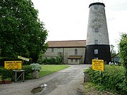
Carlton also has a Church of England Voluntary Controlled Primary (CEVCP) School. Prominent on the skyline is Skoulding's Mill, a tower windmill which has been converted to residential accommodation.
| ("Wikimedia Commons" has material about Carlton, Suffolk) |
References
- ↑ National Heritage List 1030668: Church of St Peter (Grade I listing)
