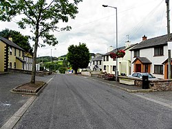
Cappagh, Tyrone
| Cappagh | |
| Tyrone | |
|---|---|

| |
| Location | |
| Grid reference: | H696666 |
| Location: | 54°32’34"N, 6°55’33"W |
| Data | |
| Dialling code: | 028 |
| Local Government | |
Cappagh is a small village and townland by Pomeroy in Tyrone. It is between Pomeroy, Ballygawley, Galbally and Carrickmore, with the hamlet of Galbally about one mile to the east. Most of the land around Cappagh is farmland although a quarry lies just outside the village.
The name of the village is from the Gaelic Ceapach, meaning 'tilled or cultivated land'[1]
The townland covers 464 acres, in the Barony of Dungannon Middle.[2]
About the village
Cappagh Mountain rises up behind the village to 948 feet above sea level. The area around Cappagh has fine mountain scenery where the land is a mixture of rural pastures and bog. These bog and peat lands still provide turf for the older generation of the area.
King James's Well is found beside the road, on the right travelling towards Altmore.
The village has an usual memorial, the Cappagh Monument in the middle of the village commemorating local people killed by during The Troubles. The focal point is the plaque celebrating eight terrorists; Provisional IRA members who died when they launched an attack with guns and bombs on the police base at Loughgall.[3]
Outside links
| ("Wikimedia Commons" has material about Cappagh, Tyrone) |
References
- ↑ Cappagh - Placenames NI
- ↑ "Townlands of County Tyrone". IreAtlas Townland Database. http://www.thecore.com/seanruad/.
- ↑ IRA memorial (Cappagh)
