Cambuskenneth
| Cambuskenneth Gaelic: Camas Choinnich | |
| Perthshire | |
|---|---|
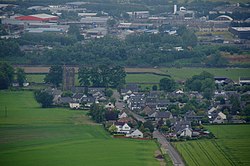
 An aerial view of Cambuskenneth | |
| Location | |
| Grid reference: | NS807939 |
| Location: | 56°7’23"N, 3°55’8"W |
| Data | |
| Population: | 250 |
| Post town: | Stirling |
| Postcode: | FK9 |
| Dialling code: | 01786 |
| Local Government | |
| Council: | Stirling |
| Parliamentary constituency: |
Stirling |
| Website: | cambuskenneth.info |
Cambuskenneth is a small village in southernmost Perthshire, caught in the narrow-necked loop of the River Forth, which here forms the county border with Stirlingshire. Across the river is the city of Stirling, to which the village is connected by a footbridge, the 1935 Cambuskenneth Bridge, and indirectly by the one road out of the village.
The village has a population of about 250. It is the site of the historic Cambuskenneth Abbey, around which the village grew in the Middle Ages. The only road access to the village is along Ladysneuk Road from Alloa Road in Causewayhead. Until the footbridge was built across the river in 1935, there was an ancient ferry to the Riverside district of Stirling.
The village is on the site of an old orchard. The village public house, the Abbey Inn was on the corner of North Street and closed in 2016. Beside the footbridge is the village hall, which is the meeting place for the community council, and across from that the park, which has a children's play area and a small football pitch.
Outside links
| ("Wikimedia Commons" has material about Cambuskenneth) |
