Burnley
| Burnley | |
| Lancashire | |
|---|---|
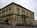
 Burnley Town Hall | |
| Location | |
| Grid reference: | SD836326 |
| Location: | 53°47’20"N, 2°14’53"W |
| Data | |
| Population: | 73,021 (2001) |
| Post town: | Burnley |
| Postcode: | BB10-12 |
| Dialling code: | 01282 |
| Local Government | |
| Council: | Burnley |
| Parliamentary constituency: |
Burnley |
Burnley is a large market town in Lancashire with a population of around 73,500. It is 21 miles north of Manchester and 25 miles east of Preston, at the confluence of the River Calder and River Brun.
The town began to develop in the early Middle Ages as a number of farming hamlets surrounded by manor houses and royal forests, gaining a market over 700 years ago. During the Industrial Revolution, it became one of Lancashire's most prominent mill towns. At its peak, it was one of the world's largest producers of cotton cloth, and a major centre of engineering. Burnley now has a post-industrial economy and landscape, and is increasingly a dormitory town for Manchester, Leeds and the M65 motorway corridor.
Contents
Name
The name Burnley is believed to have been derived from Brun Lea meaning 'meadow by the River Brun'.[1] Various other spellings have been used: Bronley (1241), Brunley (1251) and commonly Brumleye (1294) [2]
History
Stone Age flint tools and weapons have been found on the moors around the town,[1] as have numerous tumuli, stone circles, and some hill forts (see: Castercliff Camp, which dates from around 600 BC). Also, modern-day Back Lane, Sump Hall Lane and Noggarth Road follow the route of a classic ridge road running east-west to the north of the town. This indicates that the town area was populated during the Iron Age and was probably in the realm of the Brigantes.
A few Roman coin have been found but with no evidence of a settlement of the time in the town. However, Gorple Road (running east from Worsthorne) appears to follow the route of a Roman one that possibly crossed the present day centre of town on the way to the fort at Ribchester. It has been claimed that earthworks near here, known as Ring Stones Camp, Twist Castle and Beadle Hill are of Roman origin, but little archaeological information has been published to support this.
The lands above the town but the River Brun are believed to be a likely of the cataclysmic Battle of Brunanburh fought in 937; one of the most important, but little known, battles in British history, at which King Athelstan defeated the Kings of Norse Dublin, of Scotland and of Strathclyde "no greater slaughter was known in these islands since Angle and Saxon eastward hither Britain seeking ... won themselves a homeland."
There is no definitive record of a settlement until after the Norman conquest of England. In 1122 a charter granted the church of Burnley to the monks of Pontefract Abbey.[1] In its early days, Burnley was a small farming community, gaining a corn mill in 1290,[3] a market in 1294, and a fulling mill in 1296.[1] At this point, it was within the manor of Ightenhill, one of five that made up the Honor of Clitheroe, then a far more significant settlement, and consisted of no more than 50 families.[1] Little survives of early Burnley apart from the Market Cross, erected in 1295, which now stands in the grounds of the old grammar school, which is now an annexe of Burnley College.[1]
Over the next three centuries, Burnley grew in size to about 1,200 inhabitants by 1550, still centred around the church, St Peter's, in what is now known as "Top o' th' Town". Prosperous residents built larger houses, including Gawthorpe Hall in Padiham and Towneley Hall, and in 1532 St Peter's Church was largely rebuilt.[1] Burnley's grammar school was founded in 1559, and moved into its own schoolhouse next to the church in 1602.[1] Burnley began to develop in this period into a small market town. It is known that weaving was established in the town by the middle of the 17th century[1] and in 1617 a new Market House was built. The town continued to be centred on St Peter's Church until the market was moved to the bottom of what is today Manchester Road at the end of the 18th century.[1]
Industrial Revolution
In the second half of the 18th century, the manufacture of cotton began to replace that of wool. Burnley's earliest known factories – dating from the mid-century – stood on the banks of the River Calder close to where it is joined by the River Brun, and relied on water power to drive the spinning machines. The first turnpike road through Burnley was begun in 1754, linking the town to Blackburn and Colne, and by the early 19th century there were daily stagecoach journeys to Blackburn, Skipton and Manchester, the last taking just over two hours.[1] The 18th century also saw the rapid development of coal mining: the drift mines and shallow bell-pits of earlier centuries were replaced by deeper shafts meeting industrial as well as domestic demand locally, and by 1800 there were over a dozen pits in the modern-day centre of the town alone.[1]
The arrival of the Leeds and Liverpool Canal in 1796 made possible transportation of goods in bulk, bringing a huge boost to the town's economy. Dozens of new mills were constructed, along with many foundries and ironworks that supplied the cotton mills and coal mines with machinery and cast and wrought iron for construction. The town became renowned for its mill-engines and the Burnley Loom was recognised as one of the best in the world.
Disaster struck the town in 1824, when first the town's only local bank (known as Holgate's) collapsed,[4] forcing the closure of some of the largest mills. This was followed by a summer drought, which caused serious problems for many of the others, leading to high levels of unemployment and possibly contributing to the national financial crisis of 1825.
By 1830 there were 32 steam engines in cotton mills throughout the rapidly expanding town,[1] an example of which, originally installed at Harle Syke Mill, is on display in the Science Museum (London).[5]
The Irish Potato Famine led to an influx of Irish families during the 1840s, who formed a community in one of the poorest districts. At one time the Park district (modern-day town centre, around Parker St.) was known as Irish Park.
In 1848 the East Lancashire Railway Company's extension from Accrington linked the town to the nation's nascent railway network for the first time.[1] This was another significant boost to the local economy and, by 1851, the town's population had reached almost 21,000.[1]
The Cotton Famine of 1861–1865, caused by the American Civil War, was again disastrous for the town. However, the resumption of trade led to a quick recovery and, by 1866, the town was the largest producer of cotton cloth in the world.[6]
By the 1880s the town was manufacturing more looms than anywhere in the country.[7]
The Burnley Electric Lighting Order was granted in 1890, giving the Burnley Corporation (which already controlled the water supply and the making and sale of gas) a monopoly on generating and selling electricity in the town. Building of the coal-powered Electricity Works began in 1891 in Grimshaw St, close to the canal (site of modern-day Tesco) and the first supply was inaugurated on 22 August 1893, initially to generate electricity for street lights.[8]
The start of the 20th century saw Burnley's textile industry at the height of its prosperity. By 1910, there were approximately 99,000 power looms in the town,[9] and it reached its peak population of over 100,000 in 1911. However, the First World War heralded the beginning of the collapse of the British textiles industry and the start of a steady decline in the town's population.[10]
The World Wars
In the First World War almost 4,000 men died, approximately 15% of the male working-age population.[11] 250 volunteers, known as the Burnley Pals, made up Z Company of 11th Battalion, the East Lancashire Regiment, a battalion that as a whole became known by the far more infamous name of the Accrington Pals. Victoria Crosses were awarded to two soldiers from the town, Hugh Colvin and Thomas Whitham, along with a third to resident (and only son of the chief constable) Alfred Victor Smith. A memorial to the fallen was erected in 1926 in Towneley Park.
In between the wars came the great depression of the 1930s.
In the Second World War, two Distinguished Service Orders and eight Distinguished Conduct Medals, along with a large number of lesser awards, were awarded to servicemen from the town. At Heights Farm was a bombing decoy nicknamed "Manchester on the moors". Burnley escaped the bombing, largely due to the town being near the limit of German bomber range, and its proximity to higher value targets in Manchester. Although the blackout was enforced, most of the aircraft in the sky above the town would have been friendly and on training missions, or returning to the factories for maintenance. Aircraft crashes did occur, however: In September 1942 a P-38 Lightning from the 14th Fighter Group USAAF crashed near Cliviger, and Black Hameldon Hill claimed a Halifax from No. 51 Squadron RAF in January 1943 and also a B-24 Liberator from the 491st Bombardment Group USAAF in February 1945. Lucas Industries set up shadow factories, producing a wide range of electrical parts for the war effort. Notably they were involved with the Rover Company's failed attempts (and Rolls-Royce's later successful ones) to produce Frank Whittle's pioneering jet engine design, the W.2 (Rolls-Royce Welland) in Barnoldswick. Magnesium Elektron's factory in Lowerhouse became the largest magnesium production facility in Britain.[12] An unexpected benefit of the conflict for the residents of Burnley occurred in 1940. The Old Vic Theatre Company and the Sadler's Wells Opera and Ballet Companies moved from London to the town's Victoria Theatre. Burnley's main war memorial stands in Place de Vitry sur Seine next to the central library.
After the Second World War
There were widespread celebrations in the town in the summer of 1960, when Burnley FC won the old first division to become Football League champions. The Queen paid an official visit to the town in summer 1961, marking the 100th anniversary of Burnley's borough status. The rest of the decade saw large scale redevelopment in the town. Many buildings were demolished including the market hall, the cattle market, the Odeon cinema and hundreds of houses. New construction projects included the Charter Walk shopping centre, Centenary way and its flyover, the Keirby Hotel, a new central bus station, Trafalgar flats, and a number of office blocks. The town's largest coal mine, Bank Hall colliery, closed in April 1971 resulting in the loss of 571 jobs. The area of the mine has been restored as a park.[13]
In 1980 Burnley was connected to the motorway network, through the construction of the first and second sections of the M65. Although the route, next to the railway and over the former Clifton colliery site, was chosen to minimize the clearance of occupied land, Yatefield, Olive Mount and Whittlefield Mills, the Barracks, and several hundred more terrace houses had to be demolished. Unusually this route passed close to the town centre and had a partitioning effect on the districts of Gannow, Ightenhill, Whittlefield, Rose Grove and Lowerhouse to the north. The 1980s and '90s saw massive expansion of Ightenhill and Whittlefield.
In the summer of 1992, the town came to national attention following rioting on the Stoops and Hargher Clough council estates in the south west of the town.[14]
The turn of the millennium brought with it some improvement projects, notably the "Forest of Burnley" scheme,[15] which planted approximately a million trees throughout the town and its outskirts, and the creation of the Lowerhouse Lodges local nature reserve.[16]
In June 2001, during a period of wider unrest, the town again received national attention following a series of violent disturbances arising from racial tension between elements of its white and Asian communities.[17]
October 2009 saw the official opening of Burnley's first purpose-built mosque. The £1.5M privately funded Jamia Masjid Ghausia Mosque in Daneshouse was the culmination of 10 years of fundraising in the local and wider Muslim communities.[18]
Landscape about the town
Burnley lies in a natural three-forked valley at the confluence of the River Brun and the River Calder, surrounded by open fields, with wild moorland at higher altitudes. To the west of Burnley lie the towns of Padiham, Accrington and Blackburn, with Nelson and Colne to the north.
To the north west of the town is the imposing Pendle Hill, beyond which lie Clitheroe and the Ribble Valley. To the south west, the Hameldon Hills rise. Since 2007 the three turbines of the Hameldon Hill wind farm have stood on its northern flank. To the east of the town lie the Boulsworth Hill and the moors of the South Pennines, and to the south, the Forest of Rossendale. On the hills above the Cliviger area to the south east of the town stands Coal Clough wind farm, whose white turbines are visible from most of the town.
Nearby, the landmark RIBA-award winning Panopticon Singing Ringing Tree, overlooking the town from the hills at Crown Point, was installed in 2006.[19]
Due to its hilly terrain and mining history, rural areas of modern Burnley encroach the urban ones to within a mile of the town centre on the south, north west and north east.
The Pennine Way passes six miles east of Burnley; the Mary Towneley Loop, part of the Pennine Bridleway, the Brontë Way and the Burnley Way offer riders and walkers clearly-signed routes through the countryside immediately surrounding the town.
Sport
The town's sporting scene is dominated by Burnley Football Club, which was founded in 1882. The club has played its home matches at Turf Moor since 1883, where attendance currently averages 20,000.[20] The club is very well supported in the town, in fact holding the record for the highest ratio of match attendance to town population in the country.[21] It was one of the 12 founder members of the Football League in 1888 and is one of only three English league clubs to have been champions of all four professional league divisions (along with Wolves and Preston North End). Nicknamed the Clarets, they played the 2009/10 season in the Premier League, 33 years since they last played in the top flight of English football, and 50 years since they won it (List of English football champions).
There are two members of the Lancashire Cricket League in the town. Burnley Cricket Club play their home matches at Turf Moor, their ground being adjacent to the football ground, while Lowerhouse Cricket Club play at Liverpool Road.
Burnley is also home to Burnley Rugby Club (formerly Calder Vale Rugby Club 1926–2001). They field three senior sides, with teams at most junior age groups, and play at Holden Road, the site of Belvedere and Calder Vale Sports Club.
Culture and Entertainment
Museums and Galleries
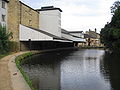
In Burnley itself there is a small contemporary visual arts gallery, the Mid-Pennine Gallery, while on the outskirts of the town there are larger galleries in two stately homes, Towneley Hall, which was bought by Burnley Corporation in 1901,[22] and Gawthorpe Hall in Padiham, which is owned by Lancashire County Council and managed by the National Trust. There are also two local museums: the Weavers' Triangle Trust operates the Visitor Centre and Museum of Local History in the historic surroundings of the Weavers' Triangle, while the Queen Street Mill Textile Museum celebrates Burnley's weaving past.
Parks
There are several large parks in the town, including Towneley Park, once the deer park for the 15th century Towneley Hall, and three winners of the Green Flag Award, including Queens Park, which hosts a summer season of brass band concerts each year, and Thompson Park, which has a boating lake and miniature railway.[23]
Activities
There is a modern 24-lane ten pin bowling centre on Finsley Gate, operated by 1st Bowl. A 9-screen multiplex cinema opened in 1995 (with 3 3D screens as of 2010), operated by Apollo Cinemas. The town's theatre, named after its former use as the Mechanics Institute, hosts touring comedians and musical acts and amateur dramatics. A second performance space, the purpose-built £1.5m Burnley Youth Theatre, opened nearby in 2005. The Amnesty International Burnley group opened in 2011; meetings are held every month. The group mission is to conduct research and generate action to prevent and end grave abuses of human rights and to demand justice for those whose rights have been violated.
Festivals
Each year, Burnley hosts the two-day Burnley National Blues Festival, one of the largest Blues festivals in the country, drawing fans from all over Britain to venues spread across the town. In the 1970s, it was also an important venue for Northern Soul;[24] several local pubs still hold regular Northern Soul nights. In recent years, the town has also hosted an annual balloon festival in Towneley Park. A funfair is usually held around the second weekend in July at Fulledge Recreation Ground, which is also the venue for the town's main Guy Fawkes Night celebration.
Miscellany
More Bénédictine is drunk in one local working men's club, the Burnley Miners' Club, than anywhere else in the world, after a local regiment stationed in Normandy during First World War brought back a taste for the drink.[25] This unusual fact was used in a question on 4th series of the BBC Show QI. The Burnley Miners Club now has its own Benedictine Lounge.
Media
- Newspapers:
- Burnley Express
- Lancashire Telegraph
- The Citizen
- The Reporter, both of which are posted to homes throughout the town.
Burnley on film
Parts of the film Whistle Down the Wind (1961), and the television series All Quiet on the Preston Front and Juliet Bravo, were filmed in the town. Numerous locations in the town were used in the 1996–1998 BBC comedy drama Hetty Wainthropp Investigates.
Queen Street Mill textile museum was used for a scene in the Oscar winning film The King's Speech,[26] and for scenes in the 2004 BBC dramatisation of Elizabeth Gaskell's North and South, as well as Life on Mars (S1 E3; 2006). It has also featured in the following BBC documentaries: Fred Dibnah's Industrial Age (E2; 1999), Adam Hart-Davies' What the Victorians Did for Us (E1; 2001), and Jeremy Paxman's The Victorians (2009).
Towneley Hall featured in the BBC comedy drama Casanova (2005) and the BBC antiques quiz Antiques Master is currently filmed there.[27]
Pictures
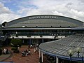
Burnley Market
right|thumb|256px|St Peter's Church
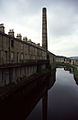
The Weavers' Triangle
Queen Street Mill Textile Museum
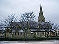
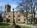
St Andrew's Church
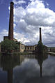
Burnley wharf
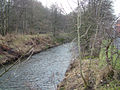
The River Brun
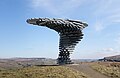
The Singing Ringing Tree
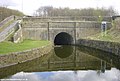
Gannow Tunnel
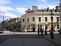
St James Street
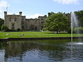
Towneley Hall in Towneley Park
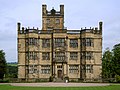
Gawthorpe Hall
Burnley Mechanics Theatre


Outside links
| ("Wikimedia Commons" has material about Burnley) |
References
- ↑ 1.00 1.01 1.02 1.03 1.04 1.05 1.06 1.07 1.08 1.09 1.10 1.11 1.12 1.13 1.14 Brian Hall (1977). Burnley: A Short History. Burnley: Burnley Historical Society. p. 40. ISBN 0-9500695-3-1.
- ↑ A History of the county of Lancaster vol 6: Burnley Township
- ↑ Lowe, John (1985). Burnley. Phillimore. p. 158. ISBN 978-0-85033-595-8.
- ↑ Burnley Express Accessed 2010
- ↑ Science Museum Accessed 2010
- ↑ Burnley Borough Council. Accessed 6 September 2007.
- ↑ Weavers triangle Accessed 2010
- ↑ Burnley Express Accessed 2010
- ↑ shttp://www.spinningtheweb.org.uk/m_display.php?irn=49&sub=nwcotton&theme=places&crumb=Burnley Spinning the Web Accessed 2010
- ↑ www.visionofbritain.org.uk. Accessed 6 September 2007.
- ↑ This is Lancashire Accessed 2010
- ↑ magnesium.com Accessed 2010
- ↑ "Bank Hall park - picture and location map". Geograph.org.uk. http://www.geograph.org.uk/photo/675291. Retrieved 2011-08-05.
- ↑ The Independent 1992 riots Accessed 2010
- ↑ Visit Burnley Accessed 2010
- ↑ Lancashire Wildlife Trust Accessed 2010
- ↑ Burnley Task Force report. Accessed 6 September 2007
- ↑ Burnley Citizen Accessed 2010
- ↑ www.panopticons.uk.net. Accessed 6 September 2007.
- ↑ Internet Football Grounds Guide. Accessed 12 February 2008.
- ↑ [1] Accessed 2010
- ↑ Towneley Hall Official Site. Accessed 24 September 2008.
- ↑ www.greenflagaward.org.uk. Accessed 10 September 2007.
- ↑ Roberts, Northern Soul Top 500, p.369
- ↑ "The Tommies' tipple is back in vogue", Manchester Evening News, 2 August 2002. Accessed 23 October 2007.
- ↑ Burnley Express Accessed 2011
- ↑ BBC Programmes Accessed 2010
- Brian Hall, Burnley: A Short History, Burnley Historical Society, 2002
- Brian Hall & Ken Spencer, Burnley: A Pictorial History, Phillimore, 1993 ISBN 0-85033-866-2
- Guy Rickards, 'Icarus Soaring: The Music of John Pickard' in Tempo, n.s., 201 (July 1997), pp. 2–5
- Kev Roberts, Northern Soul Top 500, Goldmine Publications, 2000 ISBN 0-9539291-0-8
- Walter Bennett, The History of Burnley, 4 vols., Burnley Corporation, 1946–1951
- Ken Bolton & Roger Frost, Burnley, Francis Frith, 2006 ISBN 1-84589-131-7
- Mike Townend, Burnley, Tempus Publishing, 2004 ISBN 0-7524-1566-2
- Mike Townend, Burnley Revisited, Tempus Publishing, 2006 ISBN 0-7524-3996-0