Brington, Huntingdonshire
From Wikishire
Revision as of 20:40, 17 May 2012 by RB (Talk | contribs) (Created page with '{{Infobox town |name=Brington |county=Huntingdonshire |picture=Brington Church - geograph.org.uk - 345561.jpg |picture caption=All Saints, Brington |os grid ref=TL083759 |latitud…')
| Brington | |
| Huntingdonshire | |
|---|---|
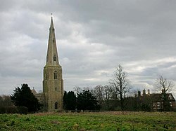
 All Saints, Brington | |
| Location | |
| Grid reference: | TL083759 |
| Location: | 52°22’14"N, 0°24’33"W |
| Data | |
| Postcode: | PE28 |
| Local Government | |
| Council: | Huntingdonshire |
Brington is a village (in the joint parish of Brington and Molesworth) in Huntingdonshire.
The village is in the very west of Huntinggdonshire, north of the A14 trunk road and close to the bounds of Northamptonshire and south of RAF Molesworth. The village of Molesworth itself is less than a mile to the west and the two villages are linked across this short distance by several footpaths.
The parish church, All Saints, has a remarkable spire for such a modest village
This Huntingdonshire article is a stub: help to improve Wikishire by building it up.