Branston, Lincolnshire
| Branston | |
| Lincolnshire | |
|---|---|
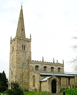
 All Saints' Church in 2005 | |
| Location | |
| Grid reference: | TF021673 |
| Location: | 53°11’40"N, 0°28’18"W |
| Data | |
| Population: | 4,019 (2001) |
| Post town: | Lincoln |
| Postcode: | LN4 |
| Dialling code: | 01522 |
| Local Government | |
| Council: | North Kesteven |
| Parliamentary constituency: |
Sleaford and North Hykeham |
Branston is a large village in Kesteven, the south-western part of Lincolnshire. The village is situated approximately four miles south-east of the city and county town of Lincoln on the B1188 road to Sleaford. It is the principal settlement in the wider civil parish of ‘Branston and Mere’, which had a population 4,019 at the 2001 census.
The 'Bran' in 'Branston' may refer to a leader with the Norse name 'Brandr',[1] in which case the name was likely coined during the Danelaw in the 9th-11th centuries, or it could be from the Old English burna for 'stream' (giving us the words bourne and burn).[2]
History
Neolithic and Bronze Age axes have been found in the village, including ten Bronze Age axes in the grounds of Branston Hall in 1906.[3] Evidence has also been found of a Roman villa or villa farm near Folly Lane: a Roman memorial stone, part of a statue, a bronze candlestick and pottery fragments.[4][5][6][7] The inscription on the Roman memorial stone is incomplete but has been translated as 'In this estate (lie the bones of) Aurelia Concessa, a very pure girl'.[4]
In the Domesday Book the manor is listed as Branztune or Branztone.[8] After the Norman Conquest, land in Branston was passed from Haminc (Hemming, Thegn of Blankney) to Walter de Aincurt (a Norman Baron and kinsman of Remigius de Fécamp).[9] In 1219 the De Aincurt estate passed from Oliver De Aincurt to his wife Amabila Camville, who remarried to Henry Le Eueske.[10][11]
The 1086 Domesday Book records a village population of 350, a figure which stayed relatively stable until the 19th century. In the 19th century the population almost tripled, rising to 1,216 in 1901.[1] In the 20th century the population trebled again, to exceed 4,000.
Farming in Branston followed an open-field system, with commons for grazing, until Enclosure in 1765.[12]
The character of the village changed much over the second half of the 20th century but Branston has retained much of its historic centre, where the majority of buildings are constructed from local limestone.[13][14]
In July 1977, more than fifty children from the junior school had to go to Lincoln County Hospital after a crop spraying aircraft inadvertently sprayed their playground. The insecticide was a mixture of meta-systox and Pirimicarb|aphox; organophosphate and carbamate compounds designed to clear crops of aphids.[15]
About the village
The village's most notable buildings are Branston Hall, built 1884-86[16] and Branston All Saints' Church (of which parts date from the 11th century).[17][6] Branston Hall was preceded by Branston old hall, dating to 1735, which burnt down in 1903. There was also a major fire at Branston All Saints Church on Christmas day in 1962.[12]
Other historic buildings include a rectory house, built in 1765, and a Wesleyan Methodist chapel, built in 1883, which is of Gothic style, previously seated 300 and closed in 1998.[18] An earlier Methodist chapel, beside it, became a Sunday school. A former public primary school on Branston High Street was built in 1873, and preceded by a fee-paying school on Hall Lane, built in 1837.[19] Opposite the church still stands a blacksmith's forge.
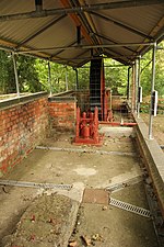
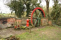
Two other public houses were once located in the village; The Plough which stood on the High Street opposite the Waggon and Horses, which was demolished in the 1970s to straighten a dangerous bend at the centre of the village, and the Bertie Arms, a small public house on Hall Lane, long ago converted into a private dwelling.[13] The Bertie Arms was named after the family which built Branston old hall. The building now occupied by the Home Guard Club was formerly a hops store. 19th Century communal water pumps have been preserved on Hall Lane and Waterwheel Lane.[12]
The village used to have a railway station which was in the parish of Heighington.[20] Before then, Station Road was called Heighington Road. Silver Street was formerly known as Bleak Street.[12]
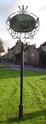
A war memorial to men of the parish killed in the First World War was erected on the village green in 1920.[21]
Abel Smith Gardens was built on former allotments.
A hotel called Moor Lodge Hotel stood on Moor Lane until it was recently demolished to make way for housing.
Geography and ecology
The village is built around the shallow valleys of three limestone streams which originate within three miles of the village, at Westfield Farm, at Mere Farm and near Highfield House. These merge and flow northwards, joining the River Witham at Washingborough. Smaller freshwater springs have been found in the valleys.
The bedrock under the village is Jurassic limestone. Fossils in it are mostly marine animals, including ammonites, crinoids and coral, reflecting the fact that the area was under the sea for much of prehistory.
Arable farmland now dominates the surrounding countryside. The main crops are wheat, barley and potatoes. Sheep, horses and pigs are also raised in the village. Wildlife found in the arable fields includes barn owl, linnet and northern lapwing.
A marsh occupies the valley in the middle of the village, part of which is designated a local nature reserve. The marsh is fed by two of the village streams but also probably by freshwater springs. Wildlife found in the local nature reserve, known as Branston Jungle, includes water rail (Rallus aquatics), |common frog (Rana temporaria), blackcap (Sylvia atricapilla), hops, yellow flag iris and alder. Woodlands surrounding Branston Hall Hotel and within the boundary of the Village Conservation Area feature a range of woodland wildflowers as well as tawny owls, stoats and jays.
Since 2014, part of the cemetery on Branston High Street has been converted into a wildflower meadow, which is traditionally managed by the Branston and Mere Parish Council. Unusual plant species in the meadow include Scabiosa columbaria, Stachys officinalis, Clinopodium vulgare and Rhinanthus minor. Some of these species were historically wiped out in the Branston area due to changing farming practices and now cannot be found anywhere else around the village. Animals observed in the wildflower meadow include vole, common toad and grey partridge.
Outside links
| ("Wikimedia Commons" has material about Branston, Lincolnshire) |
References
- ↑ 1.0 1.1 "Heritage Gateway - Results". http://www.heritagegateway.org.uk/Gateway/Results_Single.aspx?uid=MLI81595&resourceID=1006.
- ↑ Bailey, Nathan (22 November 2018). "The universal etymological English dictionary". J. and J. Knapton, D. Midwinter and A. Ward, A. Bettesworth and C. Hitch [and 8 others]. https://books.google.co.uk/books?id=o-gIAAAAQAAJ&pg=RA1-PT30&lpg=RA1-PT30&dq=branston+etymology&source=bl&ots=_YpjoA2-Gv&sig=_yBx0S3g1iyywSNJgk7Z9V0je34&hl=en&sa=X&ved=2ahUKEwjGzrG0luPeAhVEC8AKHU8mAKg4ChDoATAAegQIBxAB#v=onepage&q=branston+etymology&f=false.
- ↑ Boughton, Dot. The Early Iron Age socketed axes in Britain (2015 UCLan PhD thesis). https://www.academia.edu/30386180/The_Early_Iron_Age_socketed_axes_in_Britain_2015_UCLan_PhD_thesis_.
- ↑ 4.0 4.1 "Branston". http://www.slha.org.uk/photogallery/index.php?thislocation=Branston.
- ↑ "Aurelia Concessa – Branston’s virtuous girl". 31 May 2017. https://romanlincolnshire.wordpress.com/2017/05/31/aurelia-concessa-branstons-virtuous-girl/.
- ↑ 6.0 6.1 Pevsner, Nikolaus; Harris, John; Antram, Nicholas (22 November 1989). "Lincolnshire". Yale University Press. https://books.google.co.uk/books?id=tQqV7kdX1Y0C&pg=PA180&lpg=PA180&dq=roman+tombstone+folly+lane&source=bl&ots=S52YNW0P9T&sig=G-IGGGd69eN1HS_ZnQvlszLmJcY&hl=en&sa=X&ved=2ahUKEwjPppmBleXeAhUI_qQKHWSqBrQQ6AEwB3oECAcQAQ#v=onepage&q=roman+tombstone+folly+lane&f=false.
- ↑ "Branston Church & Village History » Rod Collins". http://www.rodcollins.com/wordpress/branston-church-village-history.
- ↑ "Parish Plan". http://www.branstonandmere.co.uk/wp-content/uploads/PC_Info_Parish_Plan.pdf.
- ↑ "Hemming 5". http://www.pase.ac.uk/jsp/Domesday?op=5&personkey=39613.
- ↑ "Appendix: Additions to volume 1 - British History Online". https://www.british-history.ac.uk/lincoln-record-soc/vol2/pp295-306.
- ↑ Salter, Patti Lee. "Amabila Camville (± 1182-????) » Ancestral Trails 2016 » Genealogie Online". https://www.genealogieonline.nl/en/ancestral-trails-2016/I95059.php.
- ↑ 12.0 12.1 12.2 12.3 Branston & Mere Parish Council - Village Pump, Hall Lane
- ↑ 13.0 13.1 "Welcome to the Branston History Group website". Branston History Group. http://www.branstonhistorygroup.org.uk/. Retrieved 23 November 2013.
- ↑ "History of Branston, in North Kesteven and Lincolnshire". a vision of Britain through time. GB Historical GIS / University of Portsmouth. http://www.visionofbritain.org.uk/place/11752.
- ↑ "AERIAL CROP SPRAYING: BRANSTON INCIDENT". Hansard. House of Lords debates 386: 612–4. 22 July 1977. http://hansard.millbanksystems.com/lords/1977/jul/22/aerial-crop-spraying-branston-incident. Retrieved 23 November 2013.
- ↑ National Heritage List 1317238: Branston Hall and Outbuildings
- ↑ National Monuments Record: No. 349378 – All Saints Church
- ↑ "Lincolnshire Archives"]. https://www.lincolnshire.gov.uk/upload/public/attachments/1244/branston_chapel.pdf.
- ↑ "Branston History Group - History of Primary Education in Branston". https://www.branstonhistorygroup.org.uk/download/95-history-of-primary-education-in-branston/primary-schools.
- ↑ National Monuments Record: No. 506987 – Branston and Heighington railway station
- ↑ Kelly's Directory of Lincolnshire 1933, p.103
- Branston: A Vision of Britain Through Time


