Difference between revisions of "Bradford Abbas"
| Line 17: | Line 17: | ||
The name of the village signifies the "Abbot's broad ford" on the [[River Ivel]], the abbot in question being that of Sherborne; the land was given to [[Sherborne Abbey]] by King Alfred the Great. | The name of the village signifies the "Abbot's broad ford" on the [[River Ivel]], the abbot in question being that of Sherborne; the land was given to [[Sherborne Abbey]] by King Alfred the Great. | ||
| − | In the dry summer of 2010 cropmarks in sun-parched fields of barley, visible from the air, revealed the existence of a previously unsuspected 1st-century temporary Roman camp, one of only four detected in southwest Britain.<ref>English Heritage reported in [https://www.bbc.co.uk/news/uk-11128297 BBC News, "Dry weather reveals archaeological 'cropmarks' in fields", 30 August 2010] accessed 7 September 2010.</ref> In the 19th century five Roman kilns were found in a field to the east of the village. Also found at the site were pottery, roof slates, bracelets and querns.<ref>'[https://www.british-history.ac.uk/rchme/dorset/vol1/pp30-34 | + | In the dry summer of 2010 cropmarks in sun-parched fields of barley, visible from the air, revealed the existence of a previously unsuspected 1st-century temporary Roman camp, one of only four detected in southwest Britain.<ref>English Heritage reported in [https://www.bbc.co.uk/news/uk-11128297 BBC News, "Dry weather reveals archaeological 'cropmarks' in fields", 30 August 2010] accessed 7 September 2010.</ref> In the 19th century five Roman kilns were found in a field to the east of the village. Also found at the site were pottery, roof slates, bracelets and querns.<ref>'[https://www.british-history.ac.uk/rchme/dorset/vol1/pp30-34 Bradford Abbas]' in 'An Inventory of the Historical Monuments in Dorset', Volume 1: West (1952), pp. 30-34</ref> |
| − | + | ||
==Outside links== | ==Outside links== | ||
Latest revision as of 23:06, 16 May 2020
| Bradford Abbas | |
| Dorset | |
|---|---|
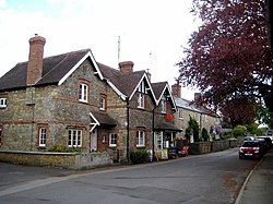
 Church Road, Bradford Abbas | |
| Location | |
| Grid reference: | ST587144 |
| Location: | 50°55’41"N, 2°35’17"W |
| Data | |
| Population: | 975 |
| Post town: | Sherborne |
| Postcode: | DT9 |
| Local Government | |
| Council: | Dorset |
| Parliamentary constituency: |
West Dorset |
Bradford Abbas is a village in north-western Dorset, three miles southeast of Yeovil (in Somerset) and five miles south-west of Sherborne. The 2011 census recorded a parish population of 975.
The name of the village signifies the "Abbot's broad ford" on the River Ivel, the abbot in question being that of Sherborne; the land was given to Sherborne Abbey by King Alfred the Great.
In the dry summer of 2010 cropmarks in sun-parched fields of barley, visible from the air, revealed the existence of a previously unsuspected 1st-century temporary Roman camp, one of only four detected in southwest Britain.[1] In the 19th century five Roman kilns were found in a field to the east of the village. Also found at the site were pottery, roof slates, bracelets and querns.[2]
Outside links
| ("Wikimedia Commons" has material about Bradford Abbas) |
- Garrett, Eric: ’Bradford Abbas - The History of a Dorset Village’ (Oxford Illustrated Press, 1989)
- Dorset OPC: Bradford Abbas historical and genealogical resources
- Bradford Abbas FC
- Bradford Abbas Parish Council
References
- ↑ English Heritage reported in BBC News, "Dry weather reveals archaeological 'cropmarks' in fields", 30 August 2010 accessed 7 September 2010.
- ↑ 'Bradford Abbas' in 'An Inventory of the Historical Monuments in Dorset', Volume 1: West (1952), pp. 30-34