Difference between revisions of "Brackenthwaite, Buttermere"
From Wikishire
(Created page with "{{Infobox town |name=Brackenthwaite |county=Cumberland |picture= |picture caption= |os grid ref=NY151221 |latitude=54.587333 |longitude=-3.313065 |population= |post town=Cocke...") |
|||
| Line 2: | Line 2: | ||
|name=Brackenthwaite | |name=Brackenthwaite | ||
|county=Cumberland | |county=Cumberland | ||
| − | |picture= | + | |picture=Palace How, Brackenthwaite - geograph.org.uk - 1007703.jpg |
| − | |picture caption= | + | |picture caption=Palace How behind Brackenthwaite |
|os grid ref=NY151221 | |os grid ref=NY151221 | ||
|latitude=54.587333 | |latitude=54.587333 | ||
Latest revision as of 19:48, 22 June 2017
| Brackenthwaite | |
| Cumberland | |
|---|---|
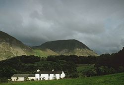
 Palace How behind Brackenthwaite | |
| Location | |
| Grid reference: | NY151221 |
| Location: | 54°35’14"N, 3°18’47"W |
| Data | |
| Post town: | Cockermouth |
| Postcode: | CA13 |
| Dialling code: | 01900 |
| Local Government | |
| Council: | Cumberland |
| Parliamentary constituency: |
Copeland |
Brackenthwaite is a village in Cumberland, within the Lake District, in Lorton Vale, below the head of Crummock Water, with the River Cocker, emerging out of the lake, flowing northwards to the west of the village. The end of the river at Cockermouth is some six miles south of Brackenthwaite. Brackenthwaite Fell rising above the village to the east is a part of the wider massif of Grasmoor.
Name
The village is recorded as Bracanethuaite in the 12th Century.
The name is believed to be from the Old Norse brakni meaning 'bush' and þveit, a common Norse village suffix.
There is another, identically named village in the county: Brackenthwaite, Westward Parish, north of here and three miles south-east of the town of Wigton.