Difference between revisions of "Blackwater, Christchurch"
From Wikishire
(Created page with "{{Infobox town |name=Blackwater |county=Hampshire |picture=Blackwater Hamlet - geograph.org.uk - 534800.jpg |picture caption=Blackwater |os grid ref=SZ135959 |latitude=50.759...") |
(No difference)
|
Latest revision as of 20:10, 27 May 2020
| Blackwater | |
| Hampshire | |
|---|---|
 Blackwater | |
| Location | |
| Grid reference: | SZ135959 |
| Location: | 50°45’32"N, 1°48’14"W |
| Data | |
| Post town: | Christchurch |
| Postcode: | BH23 |
| Local Government | |
| Council: | Bournemouth, Christchurch and Poole |
| Parliamentary constituency: |
Christchurch |
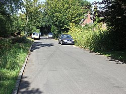
Blackwater is a small hamlet in south-western Hampshire, just north-east of Bournemouth and north-west of Christchurch. It is gathered around or obliterated by a large, grade-separated junction between the A338 Ringwood to Bournemouth road and the B3073 road to Bournemouth Airport and to Christchurch
Visitors pass through Blackwater without noticing, on the grade separated road junction here.
Blackwater was once the site of a ferry crossing on the River Stour.[1]
References
- ↑ Taylor, Christine (1994). Christchurch a Pictorial History. Shopwyke Manor Barn, Chichester, Sussex: Phillimore and Co. Ltd. p. plate no. 167. ISBN 0-85033-901-4.