Birmingham
| Birmingham | |
| Warwickshire, Worcestershire, Staffordshire | |
|---|---|
 Birmingham's skyline | |
| Location | |
| Grid reference: | SP069870 |
| Location: | 52°28’59"N, 1°53’37"W |
| Data | |
| Population: | 1,144,900 (2021) |
| Post town: | Birmingham |
| Postcode: | B |
| Dialling code: | 0121 |
| Local Government | |
| Council: | Birmingham |
| Parliamentary constituency: |
Birmingham, Edgbaston Birmingham, Erdington Birmingham, Hall Green Birmingham, Hodge Hill Birmingham, Ladywood Birmingham, Northfield Birmingham, Perry Barr Birmingham, Selly Oak Birmingham, Yardley Sutton Coldfield |
Birmingham is a major city in Warwickshire, whose urban area spreads into Worcestershire and Staffordshire. Birmingham is the most populous British city outside London, with an urban area population of 1,072,329 in 2011. Of that, the Warwickshire portion accounts for 468,812; the Worcestershire portion, 435,033; and the Staffordshire portion 168,484.
Birmingham, lies at the heart of a wider conurbation which incorporates Solihull and the major Black Country towns such as Wolverhampton, Walsall and Wednesbury (Staffordshire) and Dudley (Worcestershire); the second most populous urban conurbation in Britain, with an overall population of 2,284,093 according to the 2001 census.[1]
Birmingham's own metropolitan area includes surrounding towns to which it is closely tied through commuting.
Birmingham was a powerhouse of the Industrial Revolution, filled with factories, which led to its being dubbed "the workshop of the world" (or "the toyshop of the world") and "the city of a thousand trades".[2] Although Birmingham's industrial importance has declined, it has developed into a national commercial centre, being named as the second-best place in the United Kingdom to locate a business.[3] Birmingham is a national hub for conferences, retail and events along with an established high tech, research and development sector, supported by its three Universities. It is also the fourth-most visited city by foreign visitors in the United Kingdom,[4] has the second-largest city economy[5] and is often referred to as the "Second City".
Contents
The town
Birmingham, as the major urban centre of the Midlands, has a full range of retail, service, catering and entertainment outlets in and around the city centre. Its main retail centres are around New Street and the shopping centres in that area. Its most prestigious business district, the top address for hotels and professional offices, is around Colmore Row, where Birmingham Cathedral stands.
People from Birmingham are known as 'Brummies', a term derived from the city's nickname of 'Brum'. The name nickname “Brum” may originate from the city's dialect name, Brummagem,[6] which may in turn have been derived from one of the city's earlier names, 'Bromwicham'.[7] In the nineteenth century the word "brummagem" was used to describe cheap manufactured goods, of the sort to pour out of Birmingham's factories.
There is a distinctive Brummie dialect and accent, both of which differ from those of the adjacent Black Country.
In 2010, Birmingham was ranked as the 55th-most livable city in the world, according to the Mercer Index of worldwide standards of living.[8] The Big City Plan is a large redevelopment plan currently underway in the city centre with the aim of making Birmingham one of the top 20 most liveable cities in the world within 20 years.[9]
The city centre consists of numerous public squares including Centenary Square, Chamberlain Square and Victoria Square. The historic Old Square is located on Corporation Street. Rotunda Square and St Martin's Square are two of the newest squares in Birmingham, being located within the Bullring Shopping Centre. Brindleyplace also consists of three squares.
Geography
Birmingham is built on the Birmingham Plateau – an area of relatively high ground, ranging around 500 to 1,000 feet above sea level and crossed by Britain's main north-south watershed between the basins of the Rivers Severn and Trent. To the south and west of the city lie the Lickey Hills, the Clent Hills and Walton Hill, which reach 1,033 feet high and have extensive views over the city.
Much of the area now occupied by the city was originally a northern reach of the ancient Forest of Arden, whose former presence can still be felt in the city's dense oak tree-cover and whose echo is found in the names of districts in the wider city with names ending "-ley" (woodland clearing), such as Moseley, Saltley, Yardley, Stirchley and Hockley.[10]
Geology
The underlying geology has not constrained the growth of Birmingham, but it has affected the shape of the ground. Geologically, Birmingham is dominated by the Birmingham Fault which runs diagonally through the city from the Lickey Hills in the south-west, passing through Edgbaston and the Bull Ring to Erdington and Sutton Coldfield in the north-east.[11] To the south and east of the fault the ground is largely softer Mercia Mudstone Group interspersed with beds of Bunter pebbles and crossed by the valleys of the Rivers Tame, Rea and Cole along with their tributaries.[12] Much of this would have been laid down during the permian and triassic eras.[11]
To the north and west of the fault, varying from 150 to 600 feet higher than the surrounding area and underlying much of the city centre, lies a long ridge of harder Keuper sandstone.[13][14]
Churches
Birmingham has a wide range of churches. Most notable among them are:
- Church of England:
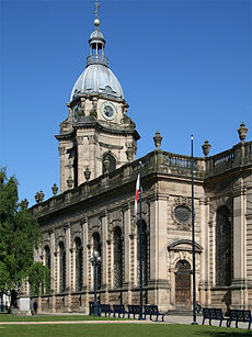
- St Philip's was upgraded from a church to a cathedral in 1905 on the creation of the Diocese of Birmingham.
- St Martin in the Bull Ring: the original parish church of Birmingham. It is a Grade II* listed building.
- Coptic Orthodox (Diocese of the Midlands): the cathedral is under construction.
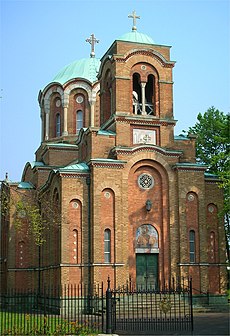
- Greek Orthodox: Cathedral of the Dormition of the Mother of God and St Andrew
- Roman Catholic: The Cathedral of Saint Chad (Province of Birmingham)
Many other Protestant denominations are represented in Birmingham, and churches of all denominations are found throughout the city.
Other religions
Prominent places of worship include:
- Jewish: Singers Hill Synagogue, built in 1856 and a Grade II* listed building.
- Muslim: Birmingham Central Mosque, one of the largest in Europe, built in the 1960s.[15]
- Sikh: Guru Nanak Nishkam Sewak Jatha Gurdwara on Soho Road in Handsworth.
The Severn Street Synagogue, the oldest surviving synagogue in Birmingham, built in 1825 in the Greek Revival style, is now a Freemason's Lodge Hall.
In and about the town
Museums
The Birmingham Museum and Art Gallery is the main art gallery and museum in Birmingham. It has renowned displays of artwork that include a leading collection of work by the Pre-Raphaelite Brotherhood and in particular the world's largest collection of works by Edward Burne-Jones.
The council also owns other museums in the city such as Aston Hall, Blakesley Hall, the Museum of the Jewellery Quarter, Soho House, and Sarehole Mill, a popular attraction for fans of J R R Tolkien.
Thinktank in the Eastside is one of the newest museums in the city, replacing the former Science and Industry Museum in Newhall Street.
The Birmingham Back to Backs are the last surviving court of back-to-back houses in the city.[16]
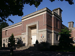
The Barber Institute of Fine Arts is both an art gallery and concert hall. It also has one of the world's most detailed and largest coin collections.[17]
Cadbury World at Bournville is a museum showing visitors the stages and steps of chocolate production and the history of chocolate and the company. Bournville itself is an example of a planned community built for the factory workers on Quaker principles and still run by the Cadbury Trust on those principles. It is in the form of a pretty villages of cottages around a village green, all in the heart of the Birmingham metropolis.
Parks and open spaces
There are over 8,000 acres of open parkland in Birmingham.[18] The largest of the parks in the civic area is Sutton Park outside Birmingham itself at Sutton Coldfield, covering 2,400 acres, making it the largest urban nature reserve in Europe.[19]
Birmingham Botanical Gardens are a Victorian creation, with a conservatory and bandstand, close to the city centre.
The Winterbourne Botanic Garden, maintained by the University of Birmingham, is also located close to the city centre.
Woodgate Valley Country Park is in Bartley Green and Quinton.
Canals
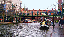
The extensive canal network in and around Birmingham is open to explore along the towpaths. Several converge at Broad Street near Gas Street Basin, where the canal junction has a roundabout. Where canals enter tunnels a lengthy diversion may be necessary. The network of canals joining Birmingham and the Black Country are known as the Birmingham Canal Navigations.
The canals in Birmingham include:
- Grand Union Canal
- BCN Main Line (formerly called The Birmingham Canal)
- Birmingham and Fazeley Canal
- Digbeth Branch Canal
- The Engine Arm
- Gower Branch Canal
- Worcester and Birmingham Canal
Many other canals, whether long-distance routes, arms or loops exist in the other suburbs and in the Black Country.
History
Some of the earliest evidence of settlement in Birmingham are artefacts dating back 10,400 years discovered near Curzon Street in the city centre.[20]
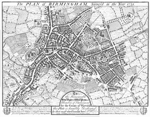
In the early 7th century Birmingham was an Anglo-Saxon farming hamlet on the banks of the River Rea.[21] It is commonly believed that the name 'Birmingham' comes from "Beorma inga ham", meaning farmstead of the sons (or descendants) of Beorma.[21] Birmingham was first recorded in written documents by the Domesday Book of 1086 by the name of Bermingeham, and at the time was a small village, worth only 20 shillings.[21] There were many variations on this name. Bermingeham is another version.
In 1166 the holder of the manor of Birmingham, Peter de Birmingham, was granted a royal charter to hold a market in his castle,[20][22] which in time became known as the Bull Ring. The market transformed Birmingham from a village to a market town. The de Birmingham family continued to be Lords of Birmingham until the 1530s when Edward de Birmingham was lost its lordship to John Dudley.[23]
As early as the 16th century, Birmingham's access to supplies of iron ore and coal meant that metalworking industries became established.[24] By the time of the English Civil War in the 17th century, Birmingham had become an important manufacturing town with a reputation for producing small arms. Arms manufacture in Birmingham became a staple trade and was concentrated in the area still known as the Gun Quarter.
During the Industrial Revolution (from the mid-18th century onwards), Birmingham grew rapidly into a major industrial centre and the town prospered. Birmingham's population grew from 15,000 in the late 17th century to 70,000 a century later.[25] During the 18th century, Birmingham was home to the Lunar Society, an important gathering of local thinkers and industrialists.[26]
Birmingham rose to national political prominence in the campaign for political reform in the early nineteenth century, with Thomas Attwood's Birmingham Political Union, bringing the country to the brink of civil war.[27] The Union's meetings on Newhall Hill in 1831 and 1832 were the largest political assemblies Britain had ever seen.[28] Lord Durham, who drafted the Reform Act, wrote that "the country owed Reform to Birmingham, and its salvation from revolution".[29]
By the 1820s, an extensive canal system had been constructed, giving greater access to natural resources to fuel to industries. The canal network ran into the heart of Birmingham from all directions, with staircases of locks and a series of tunnels forced through the hills. The most important canal is that which became the Grand Union Canal, which runs from Birmingham south-east through the Midlands to Brentford on the Thames.
Railways arrived in Birmingham in 1837 with the arrival of the Grand Junction Railway, and a year later the London and Birmingham Railway.
During the Victorian era, the population of Birmingham grew rapidly to well over half a million[30] and Birmingham became the second largest population centre in the land. Birmingham was granted city status in 1889 by Queen Victoria.[31] The city established its own university in 1900.[32]
Birmingham suffered heavy bomb damage during the Second World War's "Birmingham Blitz". The second wave of destruction was the city's extensive redevelopment during the 1950s and 1960s. This included the construction of large tower block estates, such as Castle Vale. The Bull Ring was reconstructed and New Street Station was redeveloped.
In recent years, Birmingham has been transformed once more; new squares such as Centenary Square and Millennium Place have been laid out. Old streets, buildings and canals have been restored, the pedestrian subways have been removed, and the 1960s Bull Ring shopping centre has been replaced once again.[33] These were the first steps in the local council's plans to reshape the city, which have become known as the Big City Plan.[34]
In the decades following the Second World War, the ethnic makeup of Birmingham changed significantly, as it received waves of immigration from the Commonwealth of Nations and beyond.[35] The city's population peaked in 1951 at 1,113,000 residents.[30] The 2021 census returned a population of 1,144,900, although this includes Sutton Coldfield and other annexations in the preceding 70 years.
Architecture
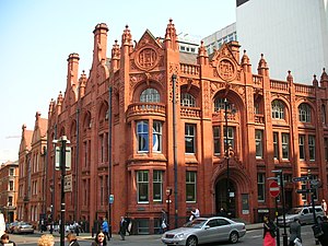
Birmingham is chiefly a product of the 18th, 19th, and 20th centuries; its growth began during the Industrial Revolution. Consequently, relatively few buildings survive from its earlier history, and those that do are protected. There are 1,946 listed buildings in Birmingham and thirteen scheduled ancient monuments.[36] Birmingham City Council also operate a locally listing scheme for buildings that do not fully meet the criteria for statutorily listed status.
Traces of mediæval Birmingham can be seen in the oldest churches, notably the original parish church, St Martin in the Bull Ring. A few other buildings from the mediaeval and Tudor periods survive, among them the Lad in the Lane in Erdington[37] and The Old Crown, the 15th century Saracen's Head public house and Old Grammar School in Kings Norton[38] and Blakesley Hall.
A number of Georgian buildings survive, including St Philip's Cathedral, Soho House, Perrott's Folly, the Town Hall and much of St Paul's Square.
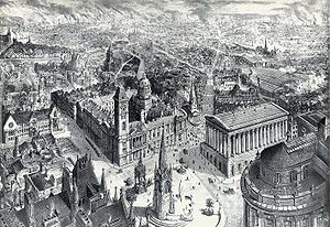
The Victorian era saw extensive building across the city. Major civic buildings such as the Victoria Law Courts (in characteristic red brick and terracotta), the Council House and the Museum and Art Gallery were built at that time.[39] St Chad's Cathedral was the first Roman Catholic cathedral to be built in the United Kingdom since the Reformation.[40]
Across the city, the need to house the industrial workers gave rise to miles of redbrick streets and terraces, many of them back-to-back houses, some of which were later to become inner-city slums.[41]
Postwar redevelopment and anti-Victorianism resulted in the loss of dozens Victorian buildings like New Street Station, and the old Central Library.[42] In inner-city areas too, much Victorian housing was redeveloped. Existing communities were relocated to tower blockestates like Castle Vale.[43]
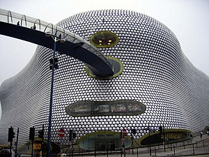
The Council now has an extensive tower block demolition and renovation programme. Many cranes have hovered over the city centre in recent years and new building have risen, including the award-winning[44] Future Systems' Selfridges building in the Bullring Shopping Centre, the Brindleyplace regeneration project and the Millennium Point science and technology centre. Funding for many of these projects has come from the European Union; the Town Hall for example received £3 million in funding from the European Regional Development Fund.[45]
Highrise development has slowed since the 1970s and mainly in recent years due to enforcements imposed by the Civil Aviation Authority on the heights of buildings as they could affect aircraft from the International Airport.[46]
Science and invention
Birmingham has been the location for some of the most important inventions and scientific breakthroughs. Local inventions and notable firsts include: gas lighting, custard powder, Brylcreem, the magnetron, the first ever use of radiography in an operation,[47] Lewis Paul and John Wyatt's first cotton roller spinning machine and Britain's first ever hole-in-the-heart operation, at the Birmingham Children's Hospital.[48]
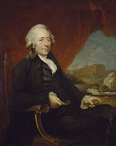
Among the city's notable scientists and inventors are Matthew Boulton, proprietor of the Soho Foundry and co-developer with Watt of the condensing steam engine; Sir Francis Galton, originator of important techniques in statistics (and of eugenics); Joseph Priestley, chemist and radical and James Watt, engineer and inventor of the practical steam engine. Many of these scientists were members of the Lunar Society, which was based in the city.[49]
City flag
In 2015 a public competition was launched to choose a city flag, which was duly won on 23 July 2015 by striking a design by Thomas Keogh and David Smith, on which a bull's head stares from the centre of a red field and at the hoist is a zigzag of blue and gold, which colours reflect the main colours on the shield of the City of Birmingham.
The Flag Institute set out the explanation for the design:[50]
"From the hoist issue two conjoined blue triangles, which together act as an abstract representation of the letter B, recalling the name of the city, the colour blue representing Birmingham’s importance in the national canal network. This is bordered by a golden zig-zag shape, similarly forming an abstract vertical letter M. This symbolises the Roman letter for 1000 and in turn Birmingham’s sobriquet as ‘the City of a thousand trades’, the zig-zag shape also represents closed locks on a canal, positioned next to the colour blue . The overall arrangement of the zig-zag and colours serves to represent the historic arms of the de Birmingham family and current city council. In the centre of the design is charged a golden bulls head for the Bull Ring market which stands at the geographic, economic and historic heart of the city."
Nearby places
Towns absorbed within the urban area
Towns absorbed within Birmingham's urban area include:
- Acocks Green (Worcestershire)
- Aston (Warwickshire)
- Bournville (Worcestershire)
- Castle Bromwich (Warwickshire)
- Edgbaston (Warwickshire)
- Erdington (Warwickshire)
- Hall Green (Worcestershire)
- Handsworth (Staffordshire)
- Harborne (Staffordshire)
- Kings Heath (Worcestershire)
- Moseley (Worcestershire)
- Small Heath (Warwickshire)
- Sparkbrook (Warwickshire)
- Stechford (Worcestershire)
- Yardley (Worcestershire)
Outside the urban area
- Atherstone
- Bedworth
- Bromsgrove
- Cannock
- Coleshill
- Coventry
- Droitwich
- Dudley
- Halesowen
- Hinckley
- Kenilworth
- Kidderminster
- Lichfield
- Nuneaton
- Oldbury
- Redditch
- Royal Leamington Spa
- Rugby
- Solihull
- Stafford
- Stourbridge
- Stratford-upon-Avon
- Sutton Coldfield
- Tamworth
- Telford
- Warwick
- Walsall
- West Bromwich
- Wolverhampton
- Worcester
References
- ↑ "Usual resident population: Census 2001, Key Statistics for urban areas". Office for National Statistics. http://www.statistics.gov.uk/statbase/ssdataset.asp?vlnk=8271&More=Y. Retrieved 9 June 2007.
- ↑ "Decline of the city of a thousand trades". Birmingham Mail. 17 April 2006. http://icbirmingham.icnetwork.co.uk/mail/news/columnists/goldberg/tm_objectid=16955982&method=full&siteid=50002&headline=decline-of-the-city-of-a-thousand-trades-name_page.html. Retrieved 2 August 2006.
- ↑ Anna Blackaby (6 October 2009). "Birmingham, biggest mover in European league table, second to London for UK business". http://www.birminghampost.net/news/newsaggregator/2009/10/06/birmingham-biggest-mover-in-european-league-table-second-to-london-for-uk-business-65233-24859371/.
- ↑ "National Statistics Online – International Visits". ONS. http://www.statistics.gov.uk/cci/nugget.asp?id=178. Retrieved 19 July 2009.
- ↑ UKmediacentre.pwc.com
- ↑ "Brummagem". Worldwidewords.com. 13 December 2003. http://www.worldwidewords.org/weirdwords/ww-bru2.htm. Retrieved 7 June 2008.
- ↑ William Hutton (1783). An History of Birmingham.
- ↑ "Quality of Living worldwide city rankings 2010 – Mercer survey". Mercer. 26 May 2010. http://www.mercer.com/qualityoflivingpr#Europe. Retrieved 27 May 2010.
- ↑ "Big City Plan Website". Birmingham City Council. http://bigcityplan.birmingham.gov.uk/. Retrieved 27 January 2010.
- ↑ Hooke, Della (2005). "Mercia: Landscape and Environment". in Brown, Michelle P.; Farr, Carol Ann. Mercia: an Anglo-Saxon kingdom in Europe. Continuum. p. 167. ISBN 0826477658. http://books.google.co.uk/books?id=H8Ke9acHFm4C&pg=PA167. Retrieved 9 May 2009.
- ↑ 11.0 11.1 Susan Ashby (10 December 2007). "The Geography of Birmingham". JPServicez Search Articles. Archived from the original on 12 February 2008. http://web.archive.org/web/20080212130436/http://www.jpservicez-searcharticles.com/article.detail.php/179361/17/Travel/144/Vacations/The_Geography_of_Birmingham. Retrieved 24 December 2007.
- ↑ Victor Skipp (1987). The History of Greater Birmingham – down to 1830. Yardley, Birmingham: V. H. T. Skipp. p. 15. ISBN 0-9506998-0-2.
- ↑ "The Growth of the City, A History of the County of Warwick: Volume 7: The City of Birmingham (1964), pp. 4–25". British History Online. http://www.british-history.ac.uk/report.aspx?compid=22959. Retrieved 22 July 2009.
- ↑ "Solid Geology – 1:250,000 scale (Source: British Geological Survey, NERC)" (gif). Department for Environment Food and Rural Affairs. http://www.defra.gov.uk/erdp/images/wmgifs/wmgeol.GIF. Retrieved 7 June 2008.
- ↑ "Birmingham Central Mosque". BBC Birmingham Faith. http://www.bbc.co.uk/birmingham/faith/places_of_worship/muslim/birmingham_central_mosque.shtml. Retrieved 7 June 2008.
- ↑ "Back to back in Birmingham" (PDF). Birmingham City Council. http://www.birmingham.gov.uk/ELibrary?E_LIBRARY_ID=93&a=1157290087529. Retrieved 7 June 2008.
- ↑ "The Coin Room". Barber Institute. http://www.barber.org.uk/coins/coinroom.html. Retrieved 7 June 2008.
- ↑ "Parks and Nature Conservation". Birmingham City Council. http://www.birmingham.gov.uk/parks. Retrieved 7 June 2008.
- ↑ "Introduction to Sutton Park". Birmingham City Council. Archived from the original on June 9, 2008. http://web.archive.org/web/20080609040835/http://www.birmingham.gov.uk/GenerateContent?CONTENT_ITEM_ID=3039&CONTENT_ITEM_TYPE=0&MENU_ID=1754. Retrieved 7 June 2008.
- ↑ 20.0 20.1 "Evidence of Stone Age man found in Digbeth". Birmingham Post. http://www.birminghampost.net/news/west-midlands-news/2009/07/24/evidence-of-stone-age-man-found-in-digbeth-65233-24226815/. Retrieved 28 July 2009.
- ↑ 21.0 21.1 21.2 "Birmingham or Brummagem?". Birmingham City Council. http://www.birmingham.gov.uk/cs/Satellite?c=Page&childpagename=SystemAdmin%2FPageLayout&cid=1223092625903&packedargs=subtype%3DPressNewsStandardTemplate%26website%3D1&pagename=BCC%2FCommon%2FWrapper%2FWrapper&rendermode=live. Retrieved 13 January 2010.
- ↑ "Historic Birmingham". Birminghamuk.com. http://www.birminghamuk.com/historicbirmingham.htm. Retrieved 30 May 2009.
- ↑ "IONA – Birmingham". Project-iona.co.uk. Archived from the original on October 20, 2007. http://web.archive.org/web/20071020214707/http://www.project-iona.co.uk/landscape/cityscape_past_and_present/birmingham. Retrieved 30 May 2009.
- ↑ Hugh Miller (1851). First Impressions of England and Its People. Gould and Lincoln.
- ↑ "Birmingham (England, United Kingdom)". Encyclopædia Britannica.
- ↑ "History of Birmingham 2". BirminghamUK. http://www.birminghamuk.com/historic2.htm. Retrieved 7 June 2008.
- ↑ Hilton, Boyd (2006). A Mad, Bad, and Dangerous People?: England, 1783–1846. Oxford University Press. pp. 426–427. ISBN 0-19-822830-9. http://books.google.com/?id=D37VByMZSaUC. Retrieved 7 January 2009.
- ↑ Flick, Carlos T. (August 1971). "Thomas Attwood, Francis Place, and the Agitation for British Parliamentary Reform". The Huntington Library Quarterly (University of California Press) 34 (4): 359. http://www.jstor.org/stable/3816950. Retrieved 10 January 2009.
- ↑ Asa Briggs (1948). "Thomas Attwood and the Economic Background of the Birmingham Political Union". Cambridge Historical Journal (Cambridge University Press) 9 (2): 190. http://www.jstor.org/stable/3020620. Retrieved 6 January 2009.
- ↑ 30.0 30.1 "Historic Population Of Birmingham". Birmingham City Council. http://www.birmingham.gov.uk/cs/Satellite?c=Page&childpagename=Lib-Central-Archives-and-Heritage%2FPageLayout&cid=1223092760414&pagename=BCC%2FCommon%2FWrapper%2FWrapper. Retrieved 13 January 2010.
- ↑ "History of Mayoralty". Birmingham.gov.uk. Archived from the original on June 9, 2008. http://web.archive.org/web/20080609052542/http://www.birmingham.gov.uk/mayors. Retrieved 7 June 2008.
- ↑ "Inside the university". University of Birmingham. Archived from the original on 2 January 2008. http://web.archive.org/web/20080102065752/http://www.bham.ac.uk/about/. Retrieved 7 June 2008.
- ↑ "Major Developments". Birmingham City Council. http://www.birmingham.gov.uk/majordevelopments. Retrieved 7 June 2008.
- ↑ Bayley, Stephen (30 June 2008). "Article reviewing the Architectural regeneration of Birmingham City Centre". London: Guardian. http://www.guardian.co.uk/artanddesign/2008/jun/29/architecture.regeneration. Retrieved 25 January 2010.
- ↑ "Birmingham's Post War Black Immigrants". Birmingham City Council. Archived from the original on 2008-06-09. http://web.archive.org/web/20080609021432/http://www.birmingham.gov.uk/GenerateContent?CONTENT_ITEM_ID=2392&CONTENT_ITEM_TYPE=0&MENU_ID=10596. Retrieved 22 July 2009.
- ↑ "Schedule of Nationally Listed Buildings of Historic Interest in Birmingham" (PDF). Birmingham City Council Planning Department. http://www.birmingham.gov.uk/ELibrary?E_LIBRARY_ID=75&a=1083070309470. Retrieved 7 June 2008.
- ↑ "The Lad In The Lane, Erdington". pub-explorer.com. Archived from the original on 22 December 2007. http://web.archive.org/web/20071222043422/http://www.pub-explorer.com/wmids/pub/ladinlaneerdington.htm.
- ↑ "History of Kings Norton". Birmingham City Council. Archived from the original on May 21, 2008. http://web.archive.org/web/20080521222034/http://www.birmingham.gov.uk/GenerateContent?CONTENT_ITEM_ID=2474&CONTENT_ITEM_TYPE=0&MENU_ID=260. Retrieved 7 June 2008.
- ↑ Anne Baltz Rodrick (2004). Self-Help and Civic Culture: Citizenship in Victorian Birmingham. Ashgate Publishing. ISBN 0-7546-3307-1.
- ↑ "Birmingham's hidden jewel". BBC Birmingham. http://www.bbc.co.uk/birmingham/content/articles/2007/04/05/st_chads_feature.shtml. Retrieved 7 June 2008.
- ↑ Phil Jones. "Tower Block Modernism vs. Urban Morphology: An analysis of Lee Bank, Birmingham" (PDF). Archived from the original on 27 February 2008. http://web.archive.org/web/20080227084303/http://www.gees.bham.ac.uk/research/cpp/membersfiles/phil/leebankabstract.pdf. Retrieved 7 June 2008.
- ↑ "Aerial View of New Street Station 1963". Birmingham City Council. Archived from the original on May 11, 2008. http://web.archive.org/web/20080511152530/http://www.birmingham.gov.uk/GenerateContent?CONTENT_ITEM_ID=89806&CONTENT_ITEM_TYPE=0&MENU_ID=10277. Retrieved 7 June 2008.
- ↑ "Castle Vale". Birmingham City Council. Archived from the original on October 12, 2007. http://web.archive.org/web/20071012100538/http://www.birmingham.gov.uk/GenerateContent?CONTENT_ITEM_ID=19750&CONTENT_ITEM_TYPE=0&MENU_ID=1453. Retrieved 7 June 2008.
- ↑ "Awards". Future Systems. http://www.future-systems.com/company/awards.html. Retrieved 7 June 2008.
- ↑ "Town Hall, Birmingham". Birmingham City Council. http://www.thsh.co.uk/page/town-hall-birmingham/. Retrieved 21 June 2010.
- ↑ "Birmingham High Places document". Birmingham City Council. Archived from the original on June 9, 2008. http://web.archive.org/web/20080609045359/http://www.birmingham.gov.uk/GenerateContent?CONTENT_ITEM_ID=13971&CONTENT_ITEM_TYPE=0&MENU_ID=1453. Retrieved 7 June 2008.
- ↑ "Major John Hall-Edwards". http://www.birmingham.gov.uk/xray.
- ↑ "Facts about Birmingham". BirminghamNet.
- ↑ "Lunar Society". BirminghamUK. http://www.birminghamuk.com/lunarsociety.htm. Retrieved 7 June 2008.
- ↑ http://www.flaginstitute.org/wp/flags/birmingham-flag
Bibliography
- An History of Birmingham (1783) by William Hutton at Project Gutenberg
- Gordon E. Cherry (1994). Birmingham A Study in Geography, History and Planning. ISBN 0-471-94900-0.
- Canon Doctor Terry Slater (1981). A History of Warwickshire. ISBN 0-85033-416-0.
- Johnathan Berg (1994). Positively Birmingham. ISBN 0-9523179-0-7.
- A. J. Gerard; Canon Doctor Terry Slater (1996). Managing a Conurbation: Birmingham and its Region. ISBN 1-85858-083-8.
Outside links
| Cities in the United Kingdom |
|---|
|
Aberdeen • Armagh • Bangor (Caernarfonshire) • Bangor (County Down) • Bath • Belfast • Birmingham • Bradford • Brighton and Hove • Bristol • Cambridge • Canterbury • Cardiff • Carlisle • Chelmsford • Chester • Chichester • Colchester • Coventry • Derby • Doncaster • Dundee • Dunfermline • Durham • Ely • Edinburgh • Exeter • Glasgow • Gloucester • Hereford • Inverness • Kingston upon Hull • Lancaster • Leeds • Leicester • Lichfield • Lincoln • Lisburn • Liverpool • City of London • Londonderry • Manchester • Milton Keynes • Newcastle upon Tyne • Newport • Newry • Norwich • Nottingham • Oxford • Perth • Peterborough • Plymouth • Portsmouth • Preston • Ripon • Rochester • Salford • Salisbury • Sheffield • Southampton • St Albans • St Asaph • St David's • Southend-on-Sea • Stirling • Stoke-on-Trent • Sunderland • Swansea • Truro • Wakefield • Wells • Westminster • Winchester • Wolverhampton • Worcester • Wrexham • York |

