Bingham
| Bingham | |
| Nottinghamshire | |
|---|---|
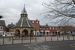
 Market Square | |
| Location | |
| Grid reference: | SK705398 |
| Location: | 52°57’0"N, 0°57’14"W |
| Data | |
| Population: | 9,000 (approx.) |
| Post town: | Nottingham |
| Postcode: | NG13 |
| Dialling code: | 01949 |
| Local Government | |
| Council: | Rushcliffe |
| Parliamentary constituency: |
Rushcliffe |
Bingham is a market town in Nottinghamshire. It stands about nine miles east of Nottingham, a similar distance south-west of Newark-on-Trent and west of Grantham. It has a population of around 9,000. It is in the Bingham Wapentake, which takes its name from the town.
The town stands where the A46 (the old Fosse Way) intersects the A52. Every Thursday, Bingham holds a market in the centre of the town, there is also a farmers' market on the third Saturday of each month held in the Market Place.
Bingham is largely a dormitory town to Nottingham, however it does retain its own distinct character and there is some employment in the town consisting of approximately 20 industrial units each employing at least 10 people, plus numerous other offices and shops in the area. Bingham also provides shopping, medical and other services to those living in the surrounding villages.
Contents
History
Romans
The Romans built a town at Margidunum (Bingham) and a settlement at the river crossing at Ad Pontem (East Stoke) on the Fosse Way that joined Isca Dumnoniorum (Exeter) to Lindum Colonia (Lincoln).
Dormitory town
Bingham has expanded vastly since the 1950s and the majority of the housing is relatively new. Most of the more historic buildings (including the Church of St Mary and All Saints, Bingham, the oldest) are in the centre.
Approximately 500 houses have lately been built bordering the A52 Grantham Road and the existing Mill Hill estate. There have been concerns that the 1000+ people who will move into these new houses will require more and improved services which so far the local councils are proving reluctant to provide.
Another 1000 houses are planned to be built as part of 'Future Bingham', north of the railway line. [1]
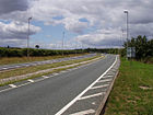
The A46, to the west of the town, is currently being upgraded to grade-separated dual-carriageway, which will increase traffic flow on the road, travelling in a much safer environment. The Widmerpool-Newark Improvement has been diverted to the west of the former Roman town to preserve the archaeology.
Things to do
Bingham Leisure Centre has sports facilities and a swimming pool. The facilities are attached to Toot Hill School.
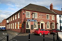
There are also six public houses in the town :
- The Moot House
- The White Lion
- The Horse and Plough
- The Bingham
- The Crown
- The Chesterfield at Bingham.
Big Society
Bingham has a very active Scout Group, comprising around 140 young people.
Bingham on film and television
- Twenty Four Seven, a film by Shane Meadows, used Bingham as a location; scenes were shot at Toot Hill top field, The Linear Walk and Bingham Boxing Club.
- This is England, a 2006 film also by Shane Meadows has scene filmed on the former RAF Newton site.
Scenes filmed in Bingham appear also in, amongst others:
- Auf Wiedersehen, Pet
- Boon
- Robot Wars (series 3
- Jungle Run
Sport
- Bingham Leisure Centre Archery Club
- British Canoe Union
- Bingham Town Youth Football Club
- Bingham Cricket Club
- Bingham Rugby Club
- Bingham Lawn Tennis Club
Outside links
- Bingham Town Council
- 1st Bingham Scout Group
- Churches:
- Sport and leisure:
- History:
References
- ↑ "Future Bingham". Crown Estates. http://www.futurebingham.co.uk/. Retrieved 2011-10-09.

