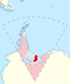
Berkner Island
| Berkner Island | |
| Location | |
| Location: | 79°30’0"S, 47°30’0"W |
| Area: | 17,000 square miles |
| Data | |
Berkner Island or Berkner Ice Rise or Hubley Island is part of the British Antarctic Territory and the largest island in the Weddell Sea. It is classified as ice rise rather than strictly an island: Berkner Island rises above the sea ice because the bedrock makes the ice dome upwards above sea level, but the bedrock beneath the ice remains below sea level: were everything to melt, it would be under water.[1]
Berkner Island is high and completely ice-covered and about 200 miles long and 95 miles wide, with an area of 17,000 square miles. Berkner is surrounded by the Filchner-Ronne Ice Shelf. The northernmost point of Berkner Island is about twelve miles from the open sea.
The island rises to 2,850 feet (3,200 feet according to other sources) and separates Ronne Ice Shelf from the Filchner Ice Shelf. It is characterized by two domes, Reinwarthhöhe in the north (2,290 feet), at 78° 19' S 46°20' W, and Thyssenhöhe in the south (2,850 feet), at 79° 34' S 45° 42' W. It is indented by three bays on the eastern side, which are from north to south: McCarthy Inlet, Roberts Inlet, and Spilhouse Inlet. Gould Bay is on the north coast. Berkner Island is about 93 miles west of the Luitpold Coast of Coats Land, the closest mainland of Greater Antarctica. eleven miles off the north-west corner of Berkner Island is Hemmen Ice Rise.
Berkner Island was discovered by members of the United States-International Geophysical Year (US-IGY) party at Ellsworth Station under the leadership of Capt. Finn Ronne, United States Navy Reserve (USNR), during the 1957-1958 season. Berkner Island was named by the United States Advisory Committee on Antarctic Names (US-ACAN) for American physicist Lloyd Berkner, engineer with the Byrd Antarctic Expedition (1928–1930).
Since 1990, Berkner Island has been a jumping off point for a number of long distance polar expeditions. Ben Saunders has planned an unsupported journey from the island to the South Pole and back.
In the 1994/1995 field season the British Antarctic Survey, Alfred Wegener Institute and the Forschungsstelle für Physikalische Glaziologie of the University of Münster cooperated in a project drilling ice cores on the North and South Domes of Berkner Island.[2]
Important Bird Area
A 1,235-acre site on fast ice 5 km north of the area where the Ronne Ice Shelf joins the north-western coast of Berkner Island, about 55 miles to the north-west of Gould Bay, has been identified as an 'Important Bird Area' by BirdLife International because it supports an emperor penguin colony. The size of the colony was estimated as about 8,000 individual birds, based on 2009 satellite imagery.[3]
| ("Wikimedia Commons" has material about Berkner Island) |
References
- ↑ United States Government Survey 'Earthshots
- ↑ Ice Core Project
- ↑ Berkner Island northwest (Gould Bay) IBA: BirdLife International
- Gazetteer and Map of The British Antarctic Territory: Berkner Island
