Benwick
| Benwick | |
| Cambridgeshire | |
|---|---|
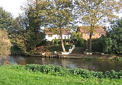
 The Nene at Benwick | |
| Location | |
| Grid reference: | TL341909 |
| Location: | 52°30’0"N, 0°1’26"W |
| Data | |
| Population: | 860 (2001) |
| Post town: | March |
| Postcode: | PE15 |
| Dialling code: | 01354 |
| Local Government | |
| Council: | Fenland |
Benwick is a village in the fenlands of Cambridgeshire, close against the Huntingdonshire border. It is approximately 15 miles from Peterborough and 30 miles from Cambridge. Benwick comprises around 330 houses, and in the 2001 Census showed the population to be 860.
The village stands on the old course of the River Nene, on a rodham; a local word for the raised, dried bed of an old watercourse.
Contents
History
The village's name is derived from the Old English bean wic or beam wic, meaning bean farm" or "tree-trunk farm".[1] Benwick was an ancient fenland village, but is unique among them by not being built on an actual "island." In 1221, Benwick had 15 tenants and by 1251, 32.[2] It used to be in the parish of Doddington,[2] one of the largest parishes in the land. Under the Doddington Rectory Division Act of 1856 it was divided into seven rectories.
From 1898 to 1966 Benwick was the terminus of the Benwick goods railway which ran from Three Horseshoes junction at Turves, on the Ely to Peterborough line. The station was on the road to Whittlesey. There was never a passenger service on the line, except a special enthusiasts train on 9 September 1956.[3]
Benwick Bygones, a book on the History of Benwick was published in 2008 by Adam Keppel-Garner and Janet Fountain.
Churches
In 1637–68 an unconsecrated chapel was erected at Benwick, and in 1850–51 St Mary's church, designed by Samuel Sanders Teulon,[4] was built on its site.[2] A Baptist chapel was built in 1818 on the site of the current Baptist graveyard but closed in 1965. St Mary's was demolished in 1985 and the Wesleyan Methodist Chapel fell into disuse in 2006, leaving Benwick without a church.[5] The font and doorway from the parish church are now at St Jude's, Westwood, Peterborough[6] and the church clock is in the museum in March.
A new church has been built alongside the Village Hall with access to the Hall. It opened in August 2012.[7]
Outside links
| ("Wikimedia Commons" has material about Benwick) |
References
- ↑ Mills, A.D. (1998). A Dictionary of English Place-names. Second Edition. Oxford University Press, Oxford. p34. ISBN 0-19-280074-4
- ↑ 2.0 2.1 2.2 'North Witchford Hundred: Doddington' - A History of the County of Cambridge and the Isle of Ely: Volume 4: City of Ely; Ely, N. and S. Witchford and Wisbech Hundreds (2002), pp. 110–116
- ↑ Six Bells Junction
- ↑ Cambridgeshire, p302, (Second edition) by Nikolaus Pevsner
- ↑ Lilyholt Road: Church. Retrieved 18 December 2009
- ↑ http://www.stjudepeterborough.org.uk/vision-and-history/
- ↑ Fenland Citizen 10 August 2012
- Astbury, A K (1987). The Black Fens (3 ed.). Wardy Hill, Ely: Providence Press. ISBN 0-903803-18-6.
- Fountain, J and Keppel-Garner, A (2008). Benwick Bygones (1 ed.). Cambridge, Cambridgeshire: Victoire Press.
