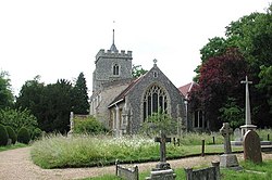
Benington, Hertfordshire
| Benington | |
| Hertfordshire | |
|---|---|
 St Peter's, Benington | |
| Location | |
| Location: | 51°53’46"N, 0°6’45"W |
| Data | |
| Population: | 1,000 (est.) |
| Post town: | Stevenage |
| Postcode: | SG2 |
| Dialling code: | 01438 |
| Local Government | |
| Council: | East Hertfordshire |
| Parliamentary constituency: |
North East Hertfordshire |
Benington is a village in eastern Hertfordshire, standing about four miles east of Stevenage. It is a small, picturesque village set in the Hertfordshire countryside and has been described as one of the most attractive villages in the county.
It has two churches, a primary school and two public houses. The village has a strong farming history, and much of the surrounding countryside is still agricultural.
Name
The name of the village is Old English and appears in the Domesday Book as Belintone.
There are two theories regarding the naming of the village. One derives the name from that of the river to the west of the village, the River Beane, so that it would be Beane meadow village or Beane folk village. The second idea, looking at the Domesday Belinton suggests that it mean Bela's clan's village (Belinga tun), after an ancient chieftain.[1]
Bennington Lordship
Benington Lordship is a Georgian manor house which is situated to the west of the village. The gardens surrounding the house stretch over seven acres and also feature the remains of a Norman castle and moat. The gardens are well known for their snowdrops and views over the surrounding Hertfordshire countryside.
The gardens also feature a Victorian folly, kitchen garden, contemporary sculptures, carp pond, wildlife areas and rose gardens.[2]
Outside links
| ("Wikimedia Commons" has material about Benington, Hertfordshire) |
References
- ↑ Benington Village Hertfordshire (2005) " Website - History", http://www.benington-herts.co.uk/history.htm
- ↑ Bennington Lordship Gardens (2006) "Website Home Page", http://www.beningtonlordship.co.uk/