Beinn a' Bhùird
| Beinn a' Bhùird | |||
| Aberdeenshire, Banffshire | |||
|---|---|---|---|
 Beinn a' Bhùird | |||
| Range: | Cairngorms | ||
| Summit: | 3,927 feet NJ092006 57°5’15"N, 3°29’60"W | ||
Beinn a' Bhùird is a mountain in the Cairngorms, one of the 18 Munros of that range. It rises up on the border of Aberdeenshire and Banffshire.
Watson in 1975 suggested that the mountain should be named Beinn Bòrd ("table hill") saying that local Gaelic speakers pronounced the mountain Paing Bòrd, while some of the older local folk still using Painna Bòrd.
The closest village to Beinn a' Bhùird is Braemar in Aberdeenshire and the most common approach by car is through this village. To reach Beinn a' Bhùird by car, the most common approach is by the Linn of Dee road along the south side of the River Dee to the Linn of Dee, looping back along the north-bank to the car park at Allanaquoich where camping is permitted. The distance between Braemar and Allanaquoich by this route is about 10 miles.
In 2006 a glider pilot from Deeside Gliding Club crashed on the hillside, spending 24 hours trapped in his plane before he was located by the RAF.[1]
Ascents
The usual ascent of Beinn a' Bhùird is from the car park at Allanaquoich walking up Glen Quoich and following the new path along the line of the old land rover road up An Diollaid.
An alternate ascent follows the Quoich Water through the Am Beitheachan to the bealach named The Sneck, between Beinn a' Bhùird and Ben Avon.
Pictures
| ("Wikimedia Commons" has material about Beinn a' Bhùird) |
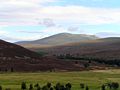
Beinn a' Bhùird from Linn of Dee road
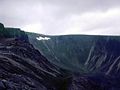
Garbh Choire on Beinn a' Bhùird
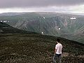
Beinn a' Bhùird from Ben Avon
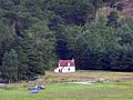
Parking at Allanaquoich


Sources