Difference between revisions of "Basingstoke Canal"
(Created page with "The Basingstoke Canal passing through Woking The '''Basingstoke Canal''' is a canal cutting through Hampshire and ...") |
(No difference)
|
Latest revision as of 19:57, 3 June 2014

The Basingstoke Canal is a canal cutting through Hampshire and Surrey. It was completed in 1794, and served to connect Basingstoke with the River Thames at Weybridge by way of the Wey Navigation.
From Basingstoke, the canal passes through or near Greywell, North Warnborough, Odiham, Dogmersfield, Fleet, Farnborough Airfield, Aldershot, Mytchett, Brookwood, Knaphill and Woking. Its eastern end is at Byfleet, where it connects to the Wey Navigation. This, in turn, leads to the River Thames at Weybridge. Its intended purpose was to allow boats to travel from the docks in the East End of London to Basingstoke.
The canal was never a commercial success. From 1950, lack of maintenance allowed the canal to become increasingly derelict. After many years of neglect, restoration began in 1977 and on 10 May 1991 the canal was reopened as a fully navigable waterway from the River Wey to almost as far as the Greywell Tunnel. However its usage is currently still limited by low water supply and conservation issues.
Contents
History
The canal was conceived as a way to stimulate agricultural development in Hampshire. A private Act of Parliament authorised the canal in 1778,[1] but problems raising the necessary capital funding meant that construction did not begin until 10 years later, in October 1788[1] and was completed on 4 September 1794. Engineer John Smeaton and his assistant William Jessop worked on the canal, along with Benjamin Henry Latrobe.[2] One of the main cargoes carried from Basingstoke was timber.[3]
The canal was never a commercial success and fell into disuse even before the construction of the London and South Western Railway, which runs parallel to the canal along much of its length. Commercial use ended in 1910 but low-level use of the canal continued.
In 1913 Mr A.J.Harmsworth tried to navigate the canal in a boat called Basingstoke. The journey was motivated by a desire to keep the canal open since the Canal Act of 1778 specified that if the canal was not used for 5 years then the land the canal was built on would be returned to the original owners. It is thought that it proved impossible to navigate the entire canal but despite this the canal was not abandoned.[3]
During the First World War, the Royal Engineers took over the running of the canal and used it to transport supplies from the Royal Arsenal in Woolwich. The canal was also used to train soldiers in boat handling [4]
In 1922, Mr A J Harmsworth, whose feat of navigation nine years before was intended to keep it open, purchased the canal and he ran a number of boats on it for a mixture of limited commercial carrying and pleasure cruising. The canal was sold upon his death in 1947 and by 1950 was in the hands of the New Basingstoke Canal Co Ltd. This company did not maintain the canal and by the mid-'60s it was essentially derelict.[1]
Restoration

In 1966, the Surrey and Hampshire Canal Society was formed by a group of local canal enthusiasts, with a view to reopening the derelict canal. They were instrumental in running a campaign that culminated in 1976 with the purchase of the canal by the two Councils.
In February 1977 a job creation project started with the aim of carrying out restoration work on the Deepcut flight of locks. The work was coordinated with the work of the canal society who organised work parties at weekends while the job creation team worked on weekdays.[5]
After about 18 years of restoration, 32 miles of the canal were formally re-opened on 10 May 1991. The western section from North Warnborough to Basingstoke remains un-navigable from the point at which it enters the Greywell Tunnel. The tunnel partially collapsed in 1932 where it passes from chalk into clay geology, and is now inhabited by a protected bat colony making it unlikely that the tunnel will be restored in the foreseeable future. Some of the former canal basin at the western end has also been lost to modern development in and around Basingstoke.
The canal is now managed by the Basingstoke Canal Authority and is open to navigation throughout the year. Lock opening times are restricted due to the very limited water supply in an attempt to postpone summer closures which have plagued the canal since construction.[6] Boat numbers are also limited to 1300 per year due to the fact that most of the canal has been designated a Site of Special Scientific Interest for its unique water chemistry, range of aquatic plants and odonata (dragonflies and damsel flies).[7][8][9]
Heathland habitats
From the midpoint heading east large areas of heathland surrounds the canal which are habitats for reptilian species, such as vipers and lizards, and birds such as Nightjars, Woodlarks and Dartford Warblers. Much of this heath survives today due to its use since the late 19th century as military training areas.
There is an information and visitor centre for the canal at Mytchett.
Lost sections of the canal
The canal used to start from the centre of Basingstoke, but the last five miles of the canal route have now been lost. This section of the canal fell into disuse due to a lack of boat traffic, general neglect and a lack of water.
There were no locks on this part of the canal after Ash and so the route generally followed the contours of the land with occasional cuttings, tunnels and embankments. The route can be partly determined by noting that the canal falls between the 75m and 80m contours on Ordnance Survey maps. The main source of water for the Basingstoke end of the top pound of the canal appears to have been the natural springs within the Greywell Tunnel. There is little natural water supplying the canal, but small streams flow into the top pound of the canal at Fleet and Aldershot. An attempt to alleviate the lack of water is apparent by a small lock just to the east of the Greywell tunnel, which appears to have raised the water level by about a foot. However this was a long section of canal with many embankments and it is likely that this was a cheap short term measure to keep the canal open, in preference to plugging the leaks from the many embankment sections on the route.
The canal started at a canal basin, roughly where the cinema in Festival Place is located. From there the canal ran alongside the River Loddon following the line of Eastrop Way. The old canal route passes under the perimeter ring road and then follows a long loop partly on an embankment to pass over small streams and water meadows towards Old Basing, where the route goes around the now ruined palace of Basing House and then through and around the eastern edge of Old Basing. Cuttings, which contain water in the winter are present through Old Basing, just off Milkingpen Lane and from the section running around farm land at the eastern edge of the village behind the Belle View Road/Cavalier Road estate. It followed another loop to go over small streams near the Hatch public house (a lot of this section was built over when constructing the M3) and headed across fields on an embankment towards Mapledurwell. The canal then headed towards a small tunnel under the Andwell Drove and then across another field partly on an embankment towards Up Nately. The section of the canal from Up Nately to the western entrance of the Greywell Tunnel still exists and is a nature reserve; there is water in the canal and the canal towpath can be walked. A permissive footpath at the western entrance to the tunnel allows walkers to access public footpaths to get to the eastern entrance of the tunnel.
The limit of navigation is about 500 yards east of the Greywell Tunnel towards North Warnborough, although the section to the tunnel entrance is probably usable by canoes. The renovated sections of the canal can then be navigated east.
The Basingstoke Canal Heritage Footpath roughly follows the canal route for 2 miles from Festival Place to Basing House.
Plans to reconnect Basingstoke with the surviving section of the Canal have been mooted several times in the past and this remains a long term aim of the Surrey and Hampshire Canal Society.[10] Another possible idea also considered was to connect the remaining canal to the Kennet and Avon navigation near Reading.
The Basingstoke Canal Authority
The canal is owned by both Hampshire County Council and Surrey County Council, with each authority owning the land within their jurisdiction. Until 1990, both councils managed their own sections separately. It was decided that a central body should manage the entire waterway and the Basingstoke Canal Authority was formed. The councils share responsibilities, and each allocates revenue to the Canal Authority, as do the six local authorities through which the canal passes.
In 1993, the canal visitor centre was opened which now acts as the central offices of the Canal Authority.
The canal is maintained by a team of 5 canal rangers and 1 senior ranger, supported by a part-time seasonal lock keeper.
Sights on the canal

Beside the canal all along its length may be found a large number of pillboxes - concrete bunkers from the Second World War. They were built part of the GHQ Line to defend against an expected German invasion.
Odiham Castle is found at the Greywell (Basingstoke) end of the canal. The canal runs through part of the castle's bailey.[11]
The Greywell Tunnel (now disused), at 1,230 yards long, was the 12th longest canal tunnel in Great Britain.[12]
Gallery
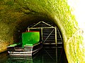
Inside the Greywell Tunnel (east end)
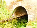
The eastern portal of Greywell Tunnel
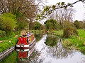
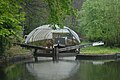
View from the 'Lift Bridge' in North Warnborough
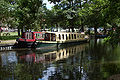
Basingstoke Canal Centre, Mytchett, Surrey
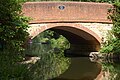
Guildford Road Bridge, Basingstoke Canal, Frimley Green, Surrey
Dry dock
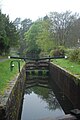
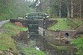
Example of a lock
Example of repairs being carried out in 2012


Outside links
| ("Wikimedia Commons" has material about Basingstoke Canal) |
- The Basingstoke Canal Authority
- Surrey and Hampshire Canal Society
- The River Wey and Wey Navigations Community Site – a non-commercial site of over 200,000 words all about the adjacent Wey Navigation with a section about the Basingstoke Canal
- Basingstoke Canal Walk (Long Distance Walkers' Association)
- ITV Documentary (video clip)
- Canal Navigations — detailed photographic essay covering the now 'lost' part of the canal between Greywell and Basingstoke
References
- ↑ 1.0 1.1 1.2 Basingstoke Canal - Canal Story
- ↑ Fazio, Michael W. (2006). The domestic architecture of Benjamin Henry Latrobe. Johns Hopkins University Press. pp. 601.
- ↑ 3.0 3.1 Michael E Ware. Britain's lost waterways. pp. 40–43. ISBN 0-86190-327-7.
- ↑ Anthony Burton. The Great Days of the Canals. p. 169. ISBN 0-7153-9264-6.
- ↑ P A L Vine, "London's Lost Route to Basingstoke", 2nd Edition 1994, ISBN 978-0750903592
- ↑ Basingstoke Canal Conservation Management Plan {http://www.hants.gov.uk/rh/canal/conservation-plan.pdf}
- ↑ "Basingstoke Canal SSSI citation". Natural England. http://www.sssi.naturalengland.org.uk/citation/citation_photo/1006588.pdf. Retrieved 10 April 2014.
- ↑ "Map of Basingstoke Canal SSSI". Natural England. http://magic.defra.gov.uk/MagicMap.aspx?startTopic=Designations&activelayer=sssiIndex&query=HYPERLINK%3D%271006588%27. Retrieved 10 April 2014.
- ↑ "Basingstoke Canal – The last 5 miles". Surrey and Hampshire Canal Society. 2004. Archived from the original on 2007-06-17. http://web.archive.org/web/20070617130424/http://www.basingstoke-canal.org.uk/last5m.htm. Retrieved 2007-06-14.
- ↑ Willoughby, Rupert (1998). A key to Odiham castle. p. 19.
- ↑ "Greywell Tunnel". Hampshire Chronicle: p. 6. 11 April 1984.
Books
- Tim Denton Wartime Defences on the Basingstoke Canal Pillbox Study Group, 2009.
- Dieter Jebens Guide to the Basingstoke Canal Basingstoke Canal Authority and the Surrey and Hampshire Canal Society, 2nd Edition, 2004.
- Dieter Jebens and Roger Cansdale Basingstoke Canal Tempus, 2007 ISBN 978-0-7524-3103-1.